Happy Friday, everyone! The U.S. is very busy right now weather-wise, so we’ll have a lot to talk about today. Hot and dry conditions continue out West, so more wildfires are possible this weekend. Also, we’re entering a pattern late this weekend into early next week where we’ll have thunderstorms across the Northern Plains and Upper Midwest while the Central U.S. deals with the heat. Finally, heavy rain and flash flooding is possible across the Appalachians next week.
Wildfire Threat Continues…
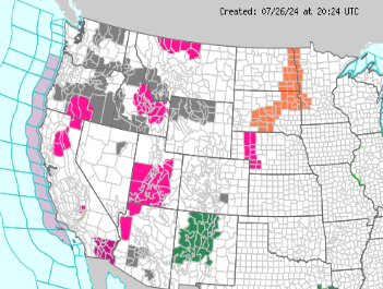
A wide variety of hazards are currently in effect across the nation, with the West being the most active region. There is a red flag warning for western Nebraska and a heat advisory for the Northern Plains, but conditions should start to improve this weekend with rain chances possible.
The main focus is the array of watches/warnings related to wildfires and heat across the country’s western half.
In the southwest, some excessive heat warnings are in effect in southern California, along with flood watches across much of New Mexico because of the monsoon. Red flag warnings exist in northwest Arizona and most of Utah due to the combination of strong winds, low relative humidity values, and warmer temperatures.
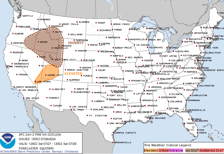
In the northwest, the threat of wildfires exists in the same region as the past couple of days. Oregon, Idaho, and Montana are under red flag warnings for tomorrow as the storm prediction center (SPC) has this area highlighted in their day 2 fire outlook shown above.
This fire-weather pattern looks to continue heading into next week with the main areas being southeast Nevada and Utah on Monday and Tuesday. Upper-level ridging is forecasted to dominate the western and central U.S., so more dry time is likely out west.
Severe Weather Possible This Weekend
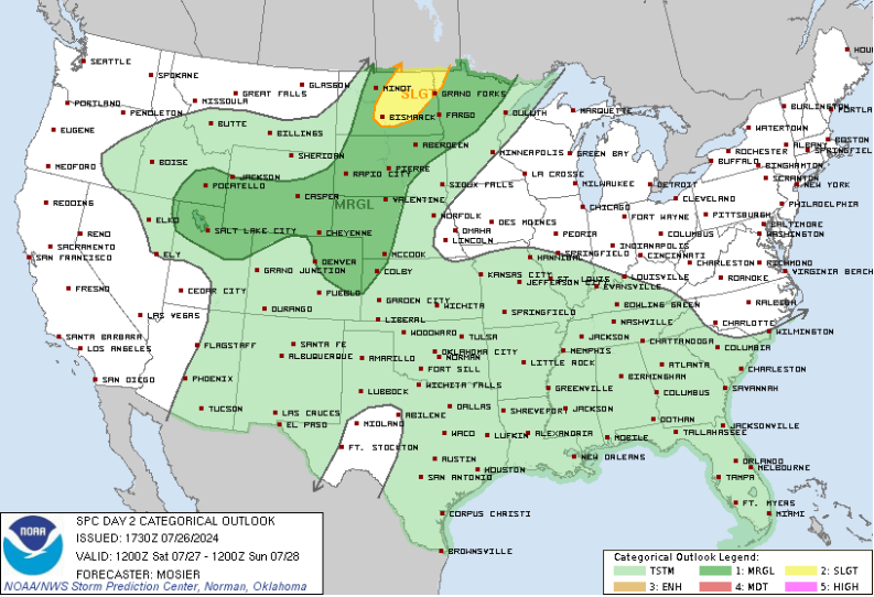
Strong to severe thunderstorms are possible late Saturday afternoon and evening across the Northern Plains. Damaging winds and hail will be the greatest hazards in North Dakota, South Dakota, and northwest Minnesota. A tornado or two is possible, especially in the afternoon before everything transitions to a wind threat.
On Sunday, guidance is hinting at another day of severe weather for the Central/Northern Plains as well as the Upper Midwest. Thunderstorms are forecasted to fire during the afternoon from northern Kansas to northwest South Dakota. A mid-level shortwave trough will likely meet with the surface low sometime Sunday evening, strengthening the low-level sheer, especially across southeast South Dakota and eastern Nebraska. Confidence is still uncertain at the moment, however, I would expect the Storm Prediction Center to upgrade this area more as we get closer to Sunday.
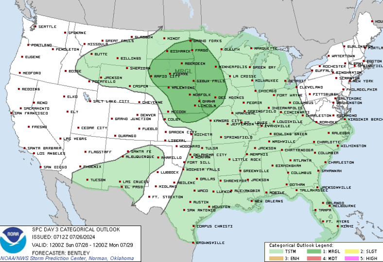
Next week, severe weather is possible across the Upper Midwest as a strong ridge is forecasted across the western and central CONUS. Storms will likely ride around the ridge and dive south into portions of Iowa, Wisconsin, Illinois, and Indiana. This pattern typically favors mesoscale convective systems (MCS) that bring damaging winds and heavy rain in a short period of time. We’ll have more on this on Sunday.
Central U.S. Heat Next Week
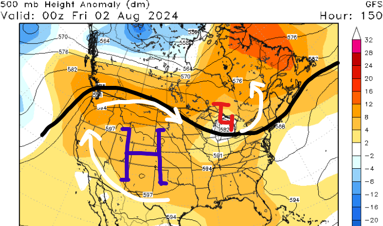
A strong ridging pattern is forecasted to develop early next week as high pressure will dominate much of the country. This results in a lot of sinking air and clear sky conditions underneath it. With more sunshine forecasted and a ridging pattern in place, above-average temperatures are likely for many of us next week.
High temperatures in the 90s and 100s appear likely for much of the western and central CONUS with little precipitation forecasted. Greater rain chances will be across the Upper Midwest and the Appalachians. Temperatures look to return closer to average by the following week (Aug 5) with greater troughing possible across the Midwest.
Heavy Rain for the Appalachians
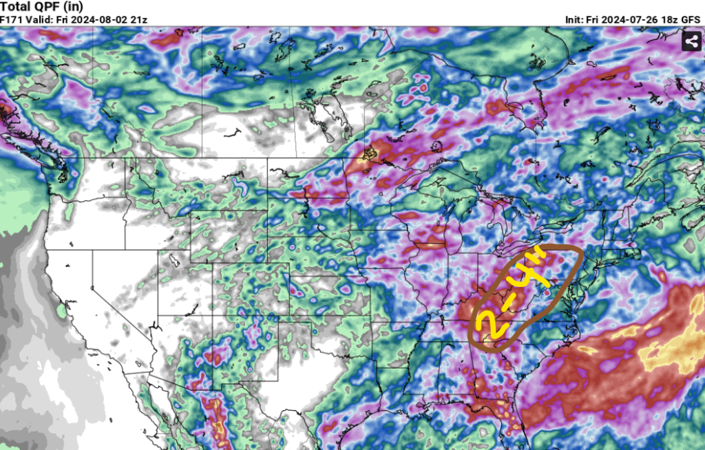
Next week could provide some heavier rain to much of the Ohio Valley and Appalachian region due to these upcoming mesoscale convective systems. This part of the country can flood quickly, so it won’t take much rain to cause issues. As of now, models are suggesting around 2-4″ of rain for next week. How fast that falls will determine how severe the flooding could be.
The higher mountains take all of the rain and dump it into nearby streams, so if you live near a creek or river in this part of the country, remember to avoid driving on flooded roads. We’ll have more confidence on this situation by the end of this weekend.


