Brace yourselves for another hot and humid day! The main story today heat, but there’s also a slight chance of some isolated storms this evening. I wouldn’t bet the farm, but you may get lucky enough to catch a cooling shower and a few rumbles of thunder. A few of these storms could bring some strong winds, so keep an eye out.


Early this morning, satellite images showed us right on the edge of a high-pressure system, while a low-pressure system over northern Illinois is bringing a cold front through the mid-Mississippi Valley and central Oklahoma. This might give us some clouds during the next 24 hours, but temperatures are still expected to soar into the upper 90s to near 100F. Even though there’s a bit less moisture in the air, dew points in the low to mid-70s will make it feel like over 110F in some sports.
Looking ahead from Saturday through next Thursday, a weather system will move out, and a cold front will drop south through our area on Saturday. While this will shift our winds to the north, it won’t bring much relief from the heat. The front will offer the chance for some more rain, though. Scattered storms will be possible Saturday with a few strong storms in there, too. Tornadoes aren’t a concern, but brief heavy rain, lightning and gusty wind will be possible.
From Sunday through Thursday, high pressure will take over, keeping things hot.
QUICK TROPICAL NOTE
All the while, we will be watching Invest 97L in the tropics. This will try to develop as it drifts toward the Gulf (the next name on the list if Debbie) is expected to move north toward the Florida panhandle – at least, as far as guidance is showing this morning.
Looking at the mid-level imagery from last night and the model guidance based on said imagery, there are three scenarios that look to play out.
Because I used the word “scenario” in a sentence, I have to post A Tribe Called Quest GIF before moving on.

Okay! “So, what… so what, so what’s the scenario?” you ask….
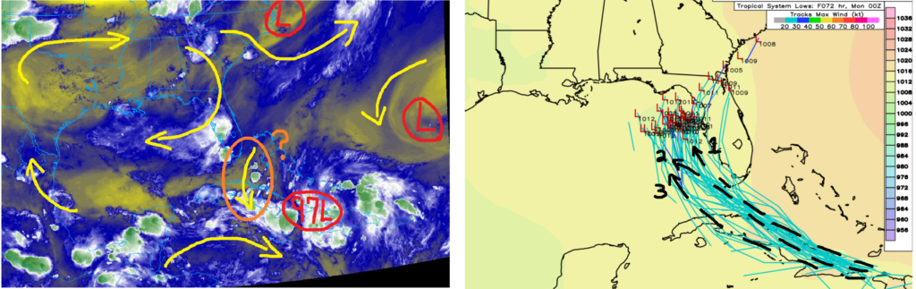
SCENARIOS
- It cross north of Cuba and and turns north up the west coast of Florida making landfall as *something* between Tampa and Panama City.
- The system crosses through Cuba and doesn’t really get orgnaized until after the island, and moves a bit slower, this allows it to meander farther west.
- Invest 97L passes south of the island with convection firing more int he Caribbean than in the Atlantic, this means a wider track into the Gulf and also farther west.
The quesiton is all about the subtle nudge that will happen as it passes by Cuba. If the nudge is enough to form south, then it becomes more of an issue for a wider population. If it stays north, then it is most likely a Florida-centric concern.
I think the most likely scenario, given model guidance, is “1” followed by “2” and then “3”.
“DO WE NEED TO WORRY IN LOUISIANA MISSISSIPPI OR ALABAMA?“
Worry? No. At this point I don’t think there is much reason to worry.
Should you monitor the weather a bit closer this weekend? Yes. Absolutely yes.
Is it a good idea to check your hurricane kit and make sure you have all the necessary plans and materials in place should something change? Also yes.
REGIONAL DAY TO DAY FORECAST
Today: Sunny. A slight chance of showers and thunderstorms this afternoon. Highs in the upper 90s. West winds around 5 mph. Chance of rain 20 percent. Heat index values up to 109.
Tonight: Mostly clear with a slight chance of showers and thunderstorms. Humid with lows in the upper 70s. Southwest winds around 5 mph. Chance of rain 20 percent. Heat index values up to 106 early in the evening.
Saturday: Sunny. A slight chance of showers and thunderstorms in the morning, then showers and thunderstorms likely in the afternoon. Humid with highs in the upper 90s. West winds around 5 mph. Chance of rain 40 percent. Heat index values up to 110.
Saturday Night: Partly cloudy. A chance of showers and thunderstorms, mainly in the evening. Humid with lows in the lower 70s. Southwest winds around 5 mph in the evening, becoming light and variable. Chance of rain 40 percent.
Sunday: Sunny. A slight chance of showers and thunderstorms in the morning, then a chance of showers and thunderstorms in the afternoon. Humid with highs in the mid 90s. East winds around 5 mph. Chance of rain 40 percent. Heat index values up to 110.
Sunday Night: Mostly clear. Lows in the mid 70s.
Monday: Sunny. A slight chance of showers and thunderstorms in the morning, then a chance of showers and thunderstorms in the afternoon. Highs in the mid 90s. Chance of rain 40 percent. Heat index values up to 105.
Monday Night: Mostly clear. Lows in the mid 70s.
Tuesday: Sunny. A slight chance of showers and thunderstorms in the afternoon. Highs in the upper 90s. Chance of rain 20 percent. Heat index values up to 110.
Tuesday Night: Mostly clear. Lows in the mid 70s. Heat index values up to 105 early in the evening.
Wednesday: Sunny. Highs in the upper 90s. Heat index values up to 110.
Wednesday Night: Mostly clear. Lows in the mid 70s.
Thursday: Sunny. A slight chance of showers and thunderstorms in the afternoon. Highs in the upper 90s. Chance of rain 20 percent. Heat index values up to 110.


One thought on “Still hot, still humid, while monitoring Invest97L: Southern MS/AL/LA Weather Forecast – 8/2/24”
Comments are closed.