Welcome to August, folks. It’s nothing short of sweltering and it’s going to stay that way for a good long while. This weekend is no exception with temperatures reaching the mid and upper 90s with heat indices reaching the mid-100s in the afternoon.
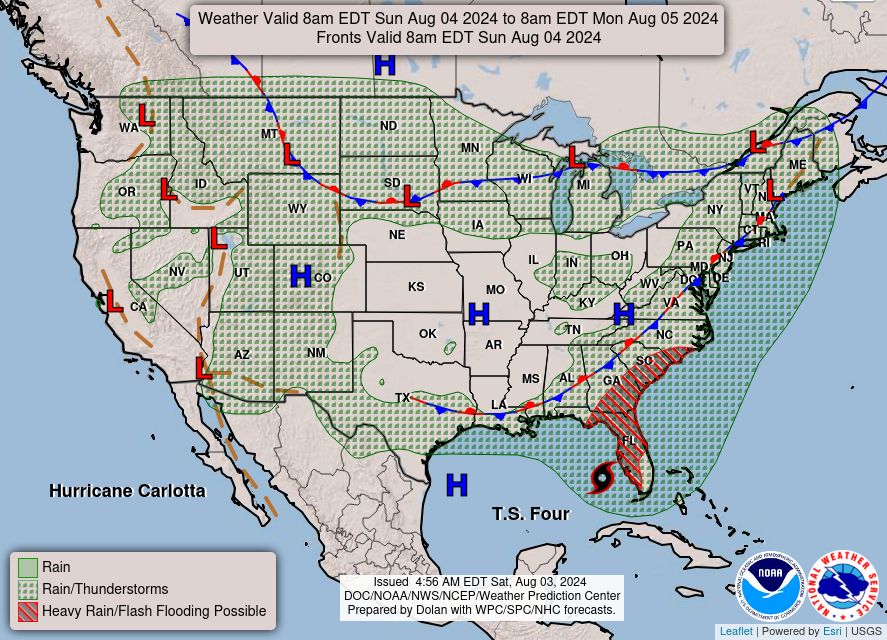
We’ll discuss the elephant in the room in a little while. Starting at the surface, a weak and stalling surface front is moving further south towards the coastline of the Deep South. This won’t mean a lot for us in terms of changing temperatures or weather conditions, but it will mean something for a particular Tropical Depression. For us, however, we may see an isolated thunderstorm today and tomorrow as the front moves South. Unfortunately, it won’t do anything to help our heat problem. Both Saturday and Sunday we’ll have highs in the mid to upper 90s and the heat index rise into the mid-100s. Overnight, the temperature will only fall into the mid 70s, so not much relief in the evening due to the high humidity.
Monday will be a similar story, however even less of a chance of a pop-up thunderstorm as TD4 moves towards landfall in Florida. We’ll be stuck with mid-100s heat index and the possibility of breaking 100 for our high in some areas of southern LA/MS/AL. Keep some electrolytes and plenty of water on you if you’re going to be outdoors.
Tropical Depression 4 (Debbie)
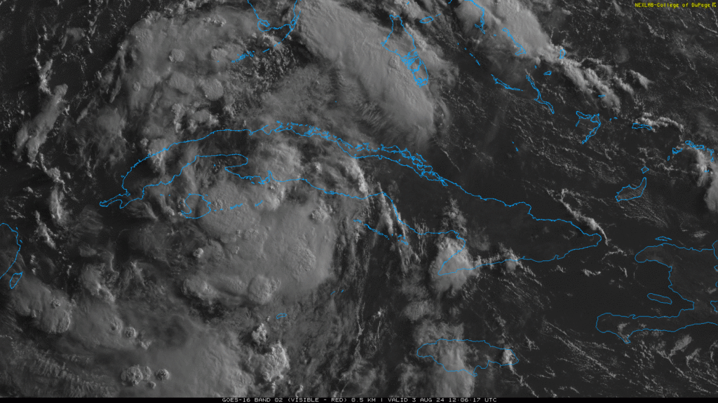
Link to Nick’s latest forecast here. So far, TD4 is forming over western Cuba and beginning to gain some traction. Looking at the Satellite imagery above, you can see the area of rotation just over the northern end of the island with a wall of convection forming just south of Cuba. The forecast so far is showing TD4 possibly pulling further west before making landfall, and looking at the water vapor imagery, it could go either way in the next day or so. We’re still keeping an eye on it and will keep you updated as it forms and the models get a grasp on what it will do.
Select Data Set:

Regional Day-to-Day Forecast
Today – A slight chance of showers and thunderstorms in the afternoon. Sunny and hot, with a high in the upper 90s. Heat index values as high as 107. North northwest wind around 5 mph. Chance of precipitation is 20%.
Tonight – Mostly clear, with a low in the mid 70s. Calm wind.
Sunday – Isolated showers and thunderstorms in the afternoon. Patchy fog before 7am. Otherwise, sunny, with a high in the upper 90s. Heat index values as high as 103. Calm wind becoming northeast around 5 mph in the afternoon. Chance of precipitation is 20%.
Sunday Night – Mostly clear, with a low around 76. Calm wind.
Monday – Sunny and hot, with a high in the upper 90s to 100. Calm wind becoming north northeast around 5 mph in the afternoon.
Monday Night – Mostly clear, with a low in the mid 70s. Calm wind.
Tuesday – Sunny and hot, with a high near 100. Calm wind becoming north northwest around 5 mph in the morning.
Tuesday Night – Clear, with a low in the mid 70s. Northwest wind around 5 mph becoming calm.
Wednesday – Sunny and hot, with a high around 100. North northwest wind around 5 mph.
Wednesday Night – Clear, with a low in the mid 70s.
Thursday – Sunny and hot, with a high near 100.
Thursday Night – Mostly clear, with a low in the mid 70s.
Friday – A 30 percent chance of showers. Sunny and hot, with a high near 100.


