THERE’S A NEWER POST! GET THE LATEST UPDATE ON TROPICAL STORM DEBBIE HERE
Summarizing the NHC: Tropical Depression Four is getting more organized, with a better-defined center over western Cuba and storm bands forming in the southern part. It has strengthened slightly with winds now at 35 mph based on observations from the Florida Keys and satellite data.

Once it crosses Cuba and moves into the eastern Gulf of Mexico, conditions are favorable for it to intensify. Initially, the strengthening may be slow, but it could become stronger quickly and possibly reach hurricane strength before hitting the northern Gulf coast. It will weaken after landfall over the southeastern U.S.
After landfall, it is expected to slow down and move over northern Florida and Georgia. There’s uncertainty about its path after three days, with some forecasts suggesting it could move into the Atlantic and then back toward the southeastern U.S. coast, while others show it staying over land.
Generally, the biggest impacts will be felt up the spine of the Florida peninsula while nearly everywhere in Florida will feel some sort of impact from the system. The peninsula can expect rain and wind and the chance for tornadoes, while the panhandle can prepare for a northerly wind, some rain and breezy conditions.
Key Points:
— Storm surge, strong winds, and heavy rains could impact other areas in Florida and the southeastern U.S. from Georgia to North Carolina through mid-next week. Stay updated as more watches and warnings may be issued.
— Expect heavy rainfall and potential flash and urban flooding in parts of Florida and the Southeast from this weekend through Thursday. River flooding is also likely.
— Hurricane conditions are possible late Sunday along the Florida Gulf Coast and Big Bend region, with Tropical Storm conditions expected further south, including Tampa Bay and the Dry Tortugas.
— There’s a danger of life-threatening storm surge along parts of Florida’s west coast from Aripeka to the Aucilla River, and possibly beyond. This includes Tampa Bay and Charlotte Harbor.
FORECAST TRACK QUESTIONS
I think we are at a bit of a breaking point today with TD4. If it continues to drift northwest and doesn’t start to organize and turn, it may make it even farther west than currently forecast.
The axis for low-level movement in the atmosphere (the part that will steer the system when it is disorganized) is indicated below by the black line. And the direction of the movement is indicated by the black arrows.
The center of TD 4 – if we eyeball it relative to that line – is west of the axis. So, the weaker this thing remains, the more of a tug it will feel to the west

This could have some pretty big implications down the line. Because the curve back to the northeast is based on the assumption that it would be on the east side of this line OR be large enough to feel a majority of the pull from the east side of this line.
If it isn’t, it may drift a bit more toward the center of the Gulf before strengthening and then finding the weakness between the two ridges (one near Texas, the other out in the Atlantic). nd that would change the landfall point as well as the area that would feel the most impacts.
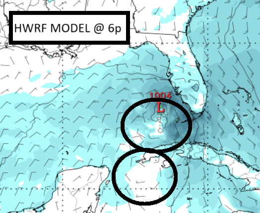
Looking at the model guidance, and ignoring our wind barbs, but stepping through time, you can see that this model thinks the axis is more meridional and shifted farther west.

It isn’t the only model, but it is something that many of the models also show.
And the initialization and first few hours of some of the hurricane model guidance shows the system still split this evening without a coherent stacked center and – in some cases – two areas of circulation at the surface.
So this raises a lot of questions about the specifics of the track.
I think the NHC is fantastic. They claim they are accurate with their track forecasts “more than 66% of the time.” But it is probably higher. But even still, that means that 33 percent of the time, they are not correct.
So don’t be surprised if you see changes to the forecast track and those changes include this thing tracking a bit farther west.


2 thoughts on “8/3/24 1145a Tropical Brief on Tropical Depression Four (eventual Debby) – further moves west possible”
Comments are closed.