Good evening, everyone! We are continuing to track Tropical Storm Debby in the eastern Gulf of Mexico which is forecasted to make landfall near the Florida Big Bend region late tonight into tomorrow morning. Flooding has already been a huge concern with this storm and will continue to be the main issue this upcoming week. Furthermore, the National Hurricane Center has highlighted a new area to watch in the Caribbean Sea. Finally, we’ll briefly touch on the active eastern Pacific.
Latest On Debby
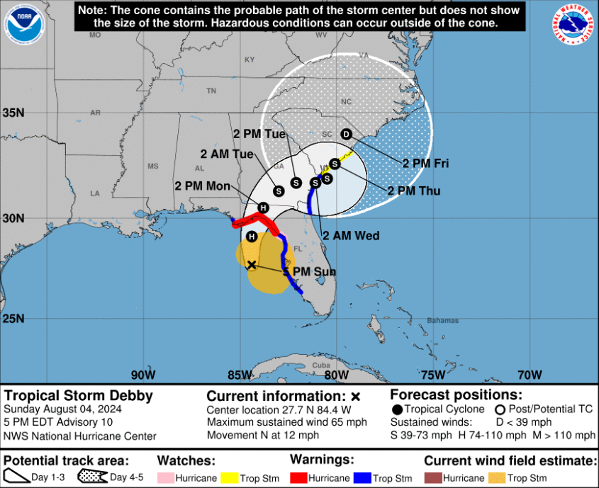
As of the 5 pm EDT update, Tropical Storm Debby still has winds of 65mph as the system continues to move northward towards Florida.
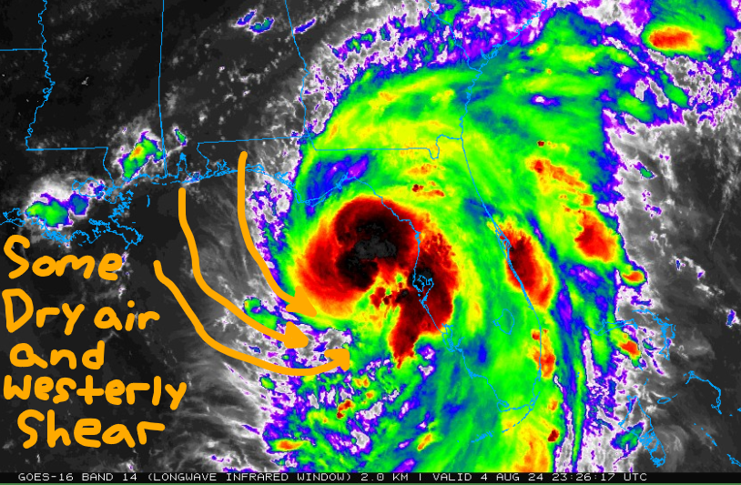
Here’s a look at the infrared imagery this evening. Debby continues to look a bit messy as nearly all of the convection and precipitation is on the east side of the storm. Some dry air is affecting the system on the west side which has likely saved it from rapidly strengthening this afternoon. Regardless, heavy rain and storm surge have caused issues this afternoon across the west coast of Florida.
For tonight, Debby will continue to slowly strengthen and organize due to nocturnal heat release where storms erupt around the center overnight. There will be a few things to watch before Debby makes landfall early tomorrow morning:
- Will dry air on the west side continue to slow development? If the storm can become more symmetrical, then it has a better chance of being a hurricane before midnight.
- Is the storm slowly wobbling northeast? The last few hours on satellite, it appears Debby is a little east of where the current track is. This could mean that landfall might take place an hour earlier depending on if it continues to track to the northeast.
- How much time does Debby get to strengthen in the Gulf? Jumping off of point #2, sea surface temperatures in the northeast Gulf of Mexico are near 90 degrees and wind shear is fairly light. If the system slows down or tracks further north, then Debby could be near category 2 strength.
Hurricane conditions will begin to take place late tonight into tomorrow morning in the Florida Big Bend region, with tropical storm conditions beginning late this evening.
Life-threatening storm surge is possible along the Gulf coast of Florida from Horseshoe Beach to Indian Pass. Storm surge is also likely southward from Tampa Bay to Fort Myers Beach.
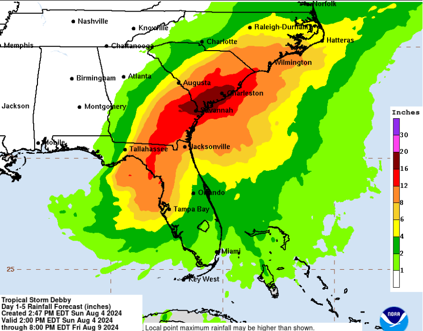
The main concern with Debby is the heavy rainfall and the likelihood of flash and urban flooding across Florida, Georgia, and the Carolinas over the next few days.
Significant river flooding is also likely with strong winds, storm surge, and heavy rain. Storm Surge warnings are in effect on the Atlantic side from Fernandina Beach, Fl to McClellanville, SC.
Model Data
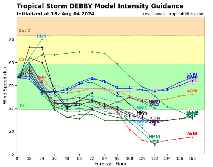
Models are in good agreement that Debby will not rapidly strengthen tonight as time is running out. Most agree that Debby will be a low-end category 1 hurricane, but this storm is still going to cause major problems.
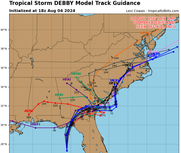
As far as agreement, I wish I could say the same for the track guidance…
There are still questions about where the heck this thing is going. The general idea is after it makes landfall in Florida tomorrow morning, Debby will slowly move off to the east-northeast and make a second landfall in South Carolina on Wednesday or Thursday. Yes, this storm is going to be around for quite some time.
What happens after Debby makes landfall in Florida tomorrow will play big into what the future is for this storm. How much time will Debby spend over the Atlantic? How slow will the storm move over the next few days? Does the system stay inland the whole week? Still, a lot of things to think about, but what we are confident in is that this will be a big-time rainmaker!
Catastrophic Rainfall & Flooding
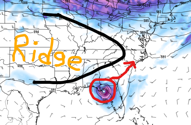
This week, ridging in the mid-levels of the atmosphere will act as a blocker and not allow any fronts or troughs to kick this thing out to sea. Instead, Debby is forecasted to hang around in the Southeast this upcoming week.
This will be a widespread and life-threatening flooding event! Over 6″ of rainfall is likely from Tampa Bay, Fl to Cape Hatteras, NC and this isn’t even including storm surge. The bullseye for catastrophic flooding includes cities such as Savannah, GA and Charleston, SC where rainfall may exceed 15″.
The Carolinas have already picked up a lot of rainfall this past month, so these areas will flood easily. The city of Charleston can flood very quickly, so please take this storm seriously. If you are asked to evacuate, do so, and be sure to take the most important belongings out of your house. It may take days or weeks for the water to recede along the Southeast coast.
After that, Debby will move northward towards the Mid-Atlantic and the Northeast, bringing more torrential rainfall and impacts later in the week.
New Area In the Caribbean
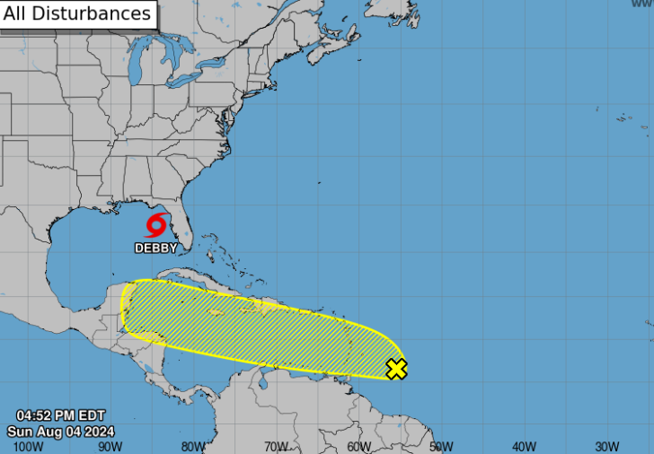
One of our waves off the main development region (MDR) has caught the attention of the NHC. As of now, this area only has a low (20%) chance of development over the next week. It will continue to track off to the west with Central America and Mexico first in its path.
Eastern Pacific Update
We’ll make this quick in case you have a headache by now.
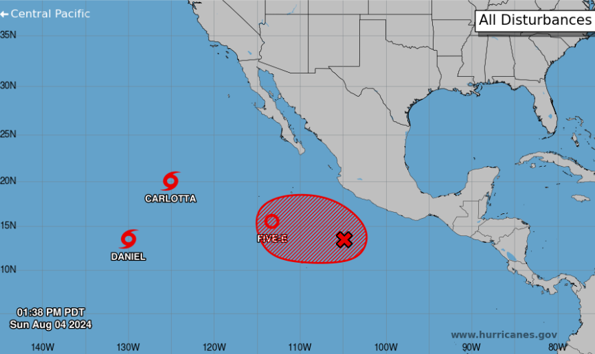
In the eastern Pacific, we have two tropical storms, one tropical depression, and one area to watch. Thankfully, there will be no land impacts over the next week with any of these systems.
Carlotta and Daniel will continue to weaken while TD 5 will likely become Tropical Storm Emilia. Finally, invest 96E (the red x) will become Tropical Storm Fabio this week as it has the best chance of reaching hurricane status.


