oday, a subtropical high will remain centered over the southeast, leading to hot and dry conditions. As a result, heat stress levels are expected to rise into the 105-110F range. Afternoon highs will reach the upper 90s to low 100s, with mostly clear skies and only a few isolated showers possible south of Highway 84. Tonight, the weather will stay quiet with temperatures dropping to the low to mid-70s, though patchy fog may develop in some areas.
From Wednesday through next Tuesday, dangerous heat will continue to be the main concern, with heat indices remaining in the 105-110F range, and possibly higher in some areas. And there is really only a scarce chance for rain on any one given day.
I’m monitoring a slightly better shot for rain by this weekend, but even then it looks like slim pickens at the moment.
Looking at the drought data, the Drought Monitor from last week showed the area with no drought. Though, when I pulled the data for today and put together a forecast based on the Euro ensembles it looks like we may dip below my local threshold of “0.3” on the soil moisture index that would indicate parts of the area are in a short-term drought.
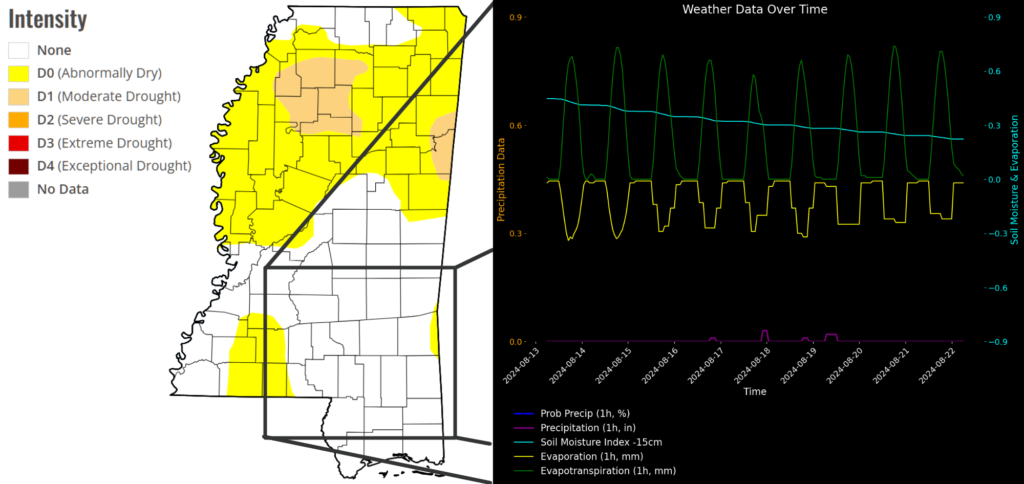
Add to that the daily evaporation stats and the lack of rainfall, I think there is a good chance that the next update features the area “Abnormally dry.”
Given that, and the lower (than normal) humidity and higher temperatures, it is probably best to avoid any outdoor burning if possible. And if you must, keep the flames down as much as you can.
REGIONAL DAY-TO-DAY FORECAST
Today: Sunny. A chance of showers and thunderstorms this afternoon. Highs in the upper 90s. Northwest winds around 5 mph. Chance of rain 30 percent. Heat index values up to 111.
Tonight: Mostly clear. A slight chance of showers and thunderstorms in the evening. Humid with lows in the mid 70s. Southwest winds around 5 mph in the evening, becoming light and variable. Chance of rain 20 percent. Heat index values up to 105 early in the evening.
Wednesday: Sunny. A slight chance of showers and thunderstorms in the afternoon. Hot with highs around 101. Northwest winds around 5 mph. Chance of rain 20 percent. Heat index values up to 112.
Wednesday Night: Mostly clear. Lows in the mid 70s. Southwest winds around 5 mph in the evening, becoming light and variable. Heat index values up to 105 early in the evening.
Thursday: Sunny. A chance of showers and thunderstorms in the afternoon. Highs in the upper 90s. Northwest winds around 5 mph, becoming east around 5 mph in the afternoon. Chance of rain 40 percent. Heat index values up to 106.
Thursday Night: Partly cloudy with a slight chance of showers and thunderstorms in the evening, then mostly clear after midnight. Lows in the mid 70s. Chance of rain 20 percent.
Friday: Mostly sunny. A slight chance of showers and thunderstorms in the morning, then a chance of showers and thunderstorms in the afternoon. Highs in the mid 90s. Chance of rain 50 percent. Heat index values up to 105.
Friday Night: Partly cloudy with a slight chance of showers and thunderstorms in the evening, then mostly clear after midnight. Lows in the mid 70s. Chance of rain 20 percent.
Saturday: Mostly sunny. A slight chance of showers and thunderstorms in the morning, then a chance of showers and thunderstorms in the afternoon. Highs in the mid 90s. Chance of rain 30 percent. Heat index values up to 110.
Saturday Night: Partly cloudy with a slight chance of showers and thunderstorms. Lows in the mid 70s. Chance of rain 10 percent.
Sunday: Mostly sunny. A slight chance of showers and thunderstorms in the morning, then a chance of showers and thunderstorms in the afternoon. Highs in the mid 90s. Chance of rain 40 percent. Heat index values up to 110.
Sunday Night: Partly cloudy. A chance of showers and thunderstorms in the evening. Lows in the lower 70s. Chance of rain 10 percent.
Monday: Mostly sunny. A slight chance of showers and thunderstorms in the morning, then a chance of showers and thunderstorms in the afternoon. Highs in the upper 90s. Chance of rain 20 percent. Heat index values up to 105.
15-DAY FORECAST


When we were going through the drought last year, it seemed like the Drought Monitor people were always a week or 2 behind on their drought maps.