We have a reasonably active weather pattern in place during the next week. Despite no “Big weathermakers” swinging through, there is plenty to talk about.
As we move into tonight and Tuesday, a dry cold front is making its way southward along Interstate 20. While this front is losing some of its upper-level support, it will still try to shove some more comfortable temperatures, clouds, and a non-zero chance for rain into the area.
That same front will begin to drift back north through Tuesday and Wednesday. That should give us a bump int he shot for some rain and storms.

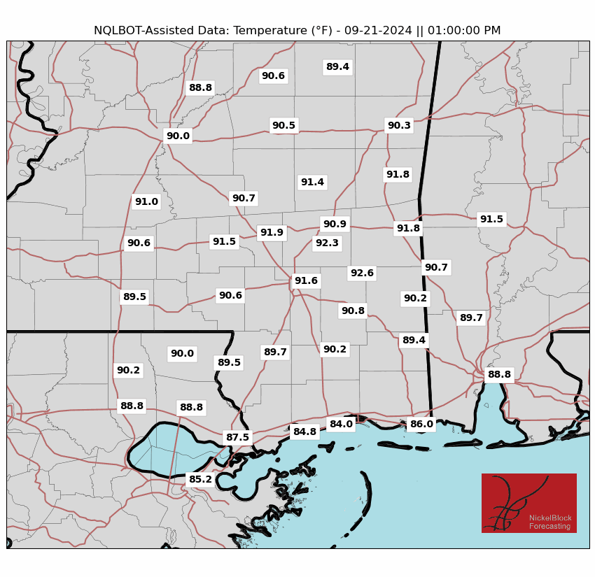
That should help to limit temperatures on Wednesday. And it looks like we may have a shot for some pretty heavy rain in places on Wednesday, too. These storms could produce from 1 to 3 inches and the potential for localized flash flooding due to storm training.
Stay tuned for updates, especially if you’re in areas prone to flooding.
TROPICAL OUTLOOK
That isn’t all, though, as we continue to keep tabs on what is happening in the Tropics.
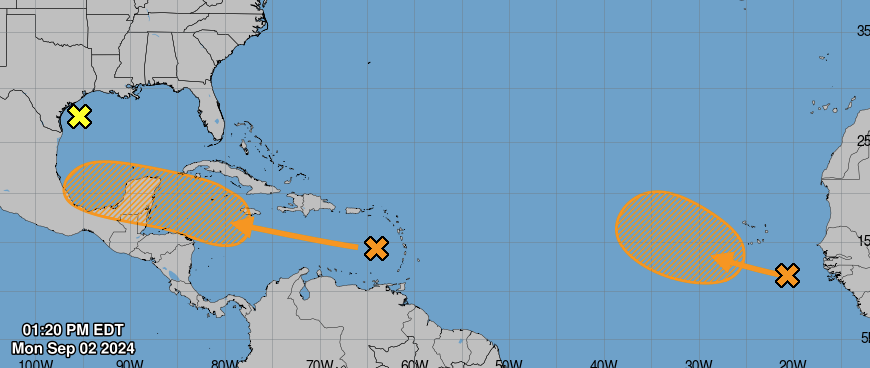
The National Hurricane Center is giving the area in the Caribbean and the area off the coast of Africa a 40-percent shot (each!) for development during the next seven days. Not a slam dunk, by any means, but still worth monitoring.
And the area near Texas continues to whirl around with very little organization anticipated. The NHC shows a “near 0” chance of development there.
For all the hub-bub on social media last week over that thing in the Caribbean, you’d think we would be looking at a Cat 5 Hurricane by now. But we are not. Partly because the overall atmosphere just isn’t ripe for the development of such an occurrence. And mostly because that was never really a viable potential to begin with and folks who took that and ran with it were simply playing with your emotions.
Looking at the model guidance from the GEFS this afternoon, we have a few areas in the open Atlantic to keep tabs on during the next 10 days as well as our area in the Caribbean. None of which end up – according to current model guidance – pointed at the northern Gulf Coast.
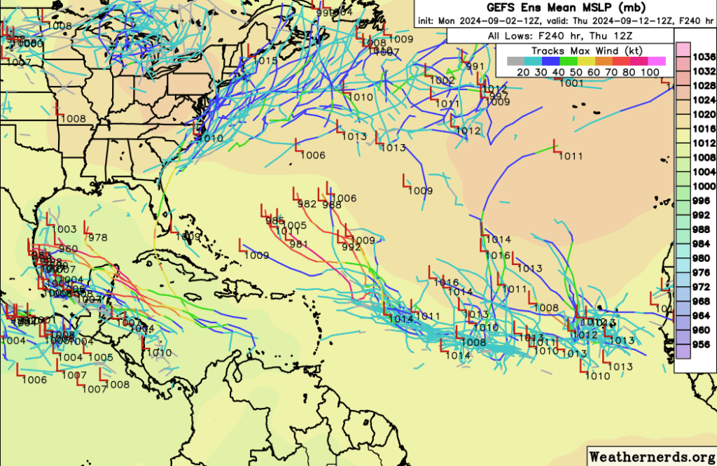
Is there other model guidance that does show such an event? With a big hurricane pointed toward the central Gulf? Sure. But this time of year, there is always a model that will show something, somewhere, doing something that looks very dangerous.
That doesn’t mean it’s a viable potential.
We have plenty to monitor in the coming days, but nothing should bother the Gulf of MExico for at least another 6 days. And likely longer.
REGIONAL DAY TO DAY FORECAST
Tonight: Partly cloudy. Lows in the lower 70s. North winds around 5 mph.
Tuesday: Sunny with a slight chance of showers and thunderstorms in the morning, then partly sunny with a chance of showers and thunderstorms in the afternoon. Highs in the mid 90s. East winds 5 to 10 mph. Chance of rain 40 percent.
Tuesday Night: Mostly cloudy. A chance of showers and thunderstorms, mainly in the evening. Lows in the lower 70s. East winds 5 to 10 mph. Chance of rain 50 percent.
Wednesday: Partly sunny with a chance of showers and thunderstorms in the morning, then mostly cloudy with showers and thunderstorms likely in the afternoon. Highs in the mid 80s. East winds 5 to 10 mph with gusts up to 20 mph. Chance of rain 70 percent.
Wednesday Night: Showers and thunderstorms likely in the evening, then showers likely with a chance of thunderstorms after midnight. Lows in the lower 70s. East winds 5 to 10 mph. Chance of rain 70 percent.
Thursday: Showers likely with a chance of thunderstorms in the morning, then showers with thunderstorms likely in the afternoon. Highs around 80. Chance of rain 80 percent.
Thursday Night: Showers likely. Thunderstorms likely, mainly in the evening. Lows around 70. Chance of rain 70 percent.
Friday: A chance of thunderstorms. A chance of showers in the morning, then showers likely in the afternoon. Highs in the lower 80s. Chance of rain 70 percent.
Friday Night: Mostly cloudy with a chance of showers and thunderstorms in the evening, then partly cloudy with a slight chance of showers and thunderstorms after midnight. Lows in the upper 60s. Chance of rain 40 percent.
Saturday: Sunny. A slight chance of showers and thunderstorms in the afternoon. Highs in the upper 80s. Chance of rain 20 percent.
Saturday Night: Mostly clear. Lows in the lower 60s.
Sunday: Sunny. Highs in the upper 80s.
Sunday Night: Mostly clear. Lows in the upper 50s.
Monday: Sunny. Highs in the upper 80s.
15-DAY FORECAST
Looking at the 15-day forecasts, we have some discrepancy between locations with the chance for hit and miss storms really playing tricks on our “NQLBOT” AI Weather Helper.

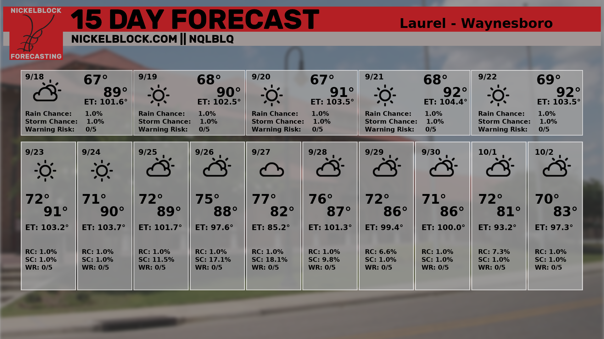
Either way, look for temperatures around 85 to 90 to hold through the next two weeks with a few days slightly cooler given the shot for some extra rain.
I will point out that the Climate Prediction Center is showing some cooler temps for a few days next week… but it won’t last long. We are back to near normal by mid-September.


