Link to Nick’s tropical outlook here
We’re still at an uncertain point with the models concerning Invest 91L. It’s still a developing tropical low pressure system in the Gulf of Mexico that has some time to turn into a depression, a storm, or maybe even a hurricane, albeit possibly a weaker one. Compound this with where it would be headed and it’s still tough to say what the outcome will be. I will go with the more averaged scenario if it is to head towards Texas/Louisiana. I’m going off of what the models have shown so far, so things will likely change in the coming days.
As 91L makes landfall, storm surge, high winds and heavy rain will all be the biggest concern for whoever is in the path. The first shot of rain looks to be Tuesday night into Wednesday as it inches closer. The rain chances will stay closer to the coast for the first 12 hours and eventually the low will move in during the day on Wednesday. For those in the path of 91L, there will be plenty of rain with flooding possible as it moves in.
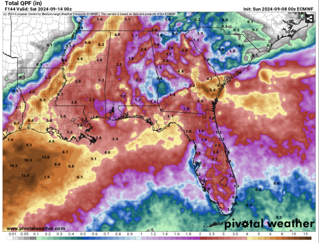
For those outside of the main system, we’ll be dealing with the outer bands of the storm for the next few days. Areas of eastern Louisiana, southern Mississippi, Alabama, and Florida will experience some of the wind gusts and heavy rain. Wind gusts up to 40 mph and rainfall totals up to 4 inches are possible in some areas. Another thing of note for areas around central and northern Louisiana and possibly the Delta is 91L’s possible inland track. Depending on the influence of the upper levels, the low will likely move north which will bring a lot of rain as it moves up, so be wary of some possible flooding.
For many in the southern and central parts of LA/MS/AL, we’ll see the rain and winds last from around Wednesday to Friday, so be prepared during the week for any watches or warnings and keep your rain jackets with you. Don’t drive on flooded roadways and in heavy winds. For those in the northern parts of Louisiana and Mississippi, this low will be moving in later on in the week and into the weekend, so please be prepared as well.
Afterwards, we will go into a more late summer temperature pattern with highs reaching the upper 80s to low 90s during the weekend into the next week. The lows will be in the low 70s hinting that the dew point is still going to be fairly high. A few afternoon showers are possible as the weekend ends.
Regional Day-to-Day Forecast
This Afternoon – Sunny, with a high in the mid 80s. North northeast wind around 10 mph.
Tonight – Mostly clear, with a low in the low 60s. North wind around 5 mph.
Monday – Mostly sunny, with a high in the upper 80s. East northeast wind 5 to 10 mph.
Monday Night – Partly cloudy, with a low in the upper 60s. East wind around 5 mph becoming calm.
Tuesday – A chance of showers and thunderstorms in the afternoon to evening. Partly sunny, with a high in the mid 80s. East wind 5 to 10 mph. Chance of precipitation is 30%.
Tuesday Night – A chance of showers and thunderstorms. Mostly cloudy, with a low around 70. East wind around 5 mph. Chance of precipitation is 40%.
Wednesday – A chance of showers, then showers and possibly a thunderstorm in the afternoon. High in the upper 70s. East wind 5 to 10 mph, with gusts as high as 20 mph. Chance of precipitation is 80%.
Wednesday Night – Showers and possibly a thunderstorm. Low around 70. East wind around 10 mph, with gusts as high as 20 mph. Chance of precipitation is 80%.
Thursday – Showers and possibly a thunderstorm during the day. High in the upper 70s. East wind around 10 mph, with gusts as high as 20 mph. Chance of precipitation is 90%.
Thursday Night – A chance of rain and thunderstorms overnight. Mostly cloudy, with a low around 69. Chance of precipitation is 40%.
Friday – A 40 percent chance of showers and thunderstorms. Partly sunny, with a high in the low 80s.
Friday Night – Partly cloudy, with a low in the mid 60s.
Saturday – A 20 percent chance of showers and thunderstorms. Mostly sunny, with a high in the mid 80s.


