Since everyone and their brother seem to be yelling about, posting, and sharing the model guidance for the next potential tropical system, I figure I should wrap some context around it. So, I wanted to take some time this morning to break down some of the stuff you’re seeing and help explore why you shouldn’t worry yet — but also why you should definitely be monitoring the weather forecast.
Here we go!
The area all of us meteorologists – and many weather enthusiasts – are monitoring is the Central American Gyre near the Yucatan.

It is swirling around with some bubbles of storms and convection, but is still rather unorganized. Recall that the Central American Gyre is a large area of lower pressure that can develop at any time during the Atlantic Hurricane Season when the atmospheric conditions are right. It doesn’t always produce tropical systems. Nor does is “turn into” a tropical system. But it can aid in the development of Tropical Storms and Hurricanes.
These types of hurricanes and tropical systems are often one-sided and messy. They can become stronger and more organized, but historically, they are not as often the Katrina’s of the world.
MODEL GUIDANCE
I want to start with the GFS operational model. This isn’t the “best” model to use for tropical specifics, but I think it does “good enough” with the background environment to help us get an idea about what the general atmosphere will look like during the next few days.
Here is a look at how the atmosphere will be setup on Sunday afternoon.

We will have a ridge of high pressure over the Gulf with a few areas of low pressure moving by to the north. Nothing to see here, just a semi-typical late summer pattern.
By midweek, we ahve a map that look slike this:

Our Highs and Lows have moved a bit. We have a decent western ridge and the high pressure in the Gulf and moved to the east. The CAG is the “?” near the Yucatan and the green little lines are the potential track based on the puzzle pieces in place in the atmosphere.
A lot of spread in the potential outcome.
Speaking of the eventual CAG, I wanted to point to Philippe Pappin’s research work. He is a National Hurricane Center Meteorologist and super-smart dude when it comes to these CAGs.
His maps show the development of “something” in the CAG by late Monday night (below, left) and then a more-organized ‘something’ by Wednesday in the northeastern quadrant (below, right).


The northeastern quadrant is the favored quadrant for CAG systems to develop.
And, to be fair, that is something that is echoed across most model guidance. The European, the American, the Canadian, the operational models, the ensemble models. Nearly all guidance suggests that the ‘something’ is going to happen near the east side of the Yucatan.
From there, we get very different results.
Here is a look at the last handful of model runs looking at where that ‘soemthing’ will be on Friday afternoon – and what it may look like:
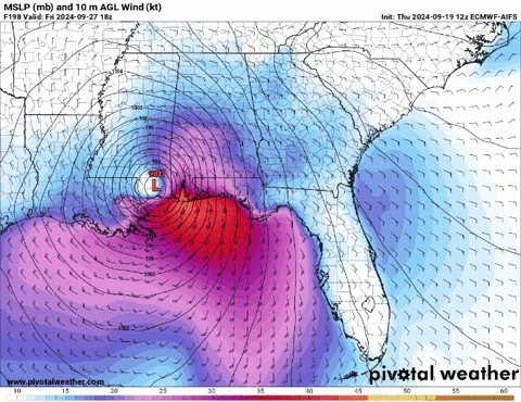
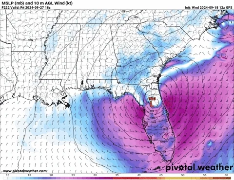
Just a mess. Some say here, some say there. Some say strong. Some day weak.
It is like a Dr. Seuss book.
But that is how it goes this early in the game. Because these models all use slightly different initial conditions. And even if they used the same initial conditions, they all use slightly different physics, so the outcome wouldn’t be the same.
You can think of it like a decision tree where some decisions are interconnected with others and sometimes it is a binary yes/no. Eventually, you will probably make it down a path of no return – sometimes snowballing, too – where you can’t make it to the same place two different ways.

A bit of a crude example, but that is how these models can work, at times, which is why you can get some wildly different results. And why sometimes one model has a Category 5 Hurricane and another has a piddly Tropical Depression.
And, at this point, neither would be “right” anyway.
But, if we were to ballpark things of the general outcome for placement, folks from Morgan City, Louisiana over to Tampa, Florida would need to pay the most attention to the forecast for the upcoming system.
Looking at the intensity forecast, the specifics are meaningless at this point. But I think we can try to pull out some threads from this fabric to make, at least a general, forecast.
These two animations are at the time of potential formation (left) and 48 hours later (right) across six different models.
It is going to be tough to follow, but I wanted to showcase both because I think we see a trend across all models that the farther southeast the formation of the system, the stronger and more northward it moves. But too far to the south and the system drifts across the Yucatan and into the Bay of Campeche as a messy weaker system.
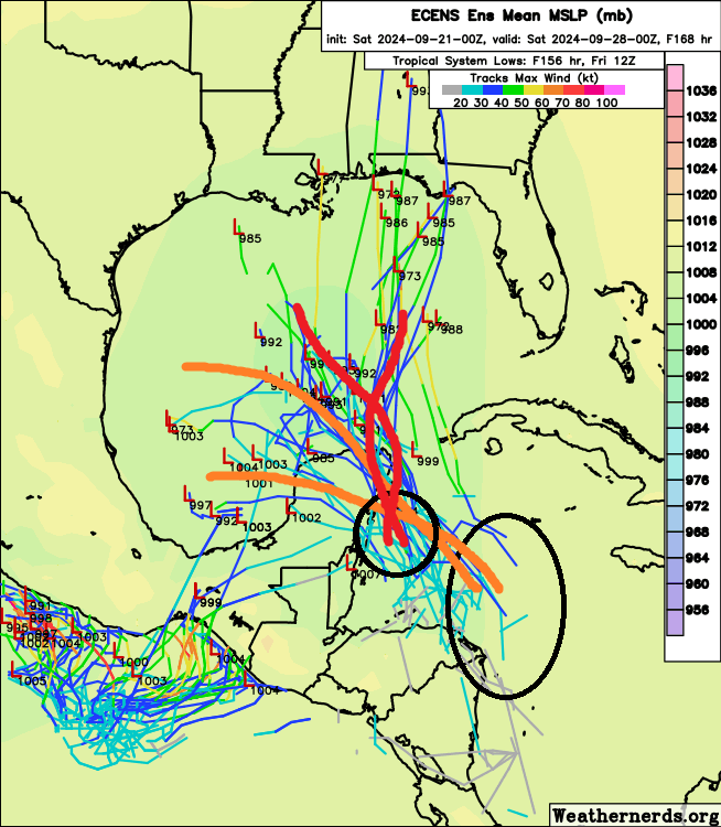
This is, somewhat, echoed in the European Ensemble data, too. Systems that form more SE drag across the Yucatan with minimum pressures in the 1990-1010 range while systems that form closer to the Yucatan lift more northward and are in the 970-980 range.
Again, I want to stress here, that the specifics of those numbers are meaningless. But the trend of one-vs-the other I think has some merit.
Given that, it looks like we are in the same boat here, too. Folks from Morgan City, Louisiana over to Tampa, Florida would need to pay the most attention to the forecast for the upcoming system.
Because if it is to travel northward, it appears to have a better chance to become a more impactful storm.
HISTORY
This is where looking back at history can help. Let’s look back at every hurricane that has moved through that area on the map.
Short of a handful of systems that formed in the eastern Caribbean and a few more that formed before reaching this section of the western Caribbean, we can get a pretty decent repository of historical analogous situations. There are a total of 31 storms on the map.
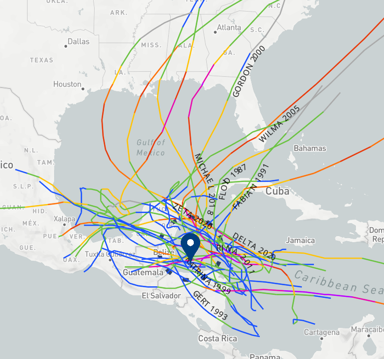
Seven of those made landfall on US soil.
Of those seven, five were probably “consequential” storms: Opal, Gordon, Nate, Michael, Zeta.
That’s not to say they all formed from the Central American Gyre. But they all got – at least – some sort of CAG-assist.
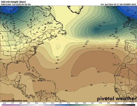
So, lets look at the atmospheric setup for those five events. Below is the 500mb map for each system about 48 hours before landfall.


Notice that each shows something slightly different. A good reminder that not all tropical systems are the same and each is going to move slightly differently than the next.
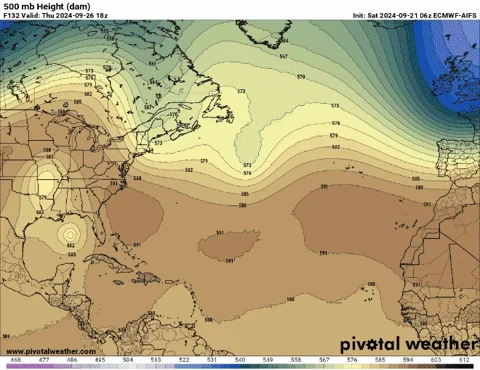
Now, let’s look at the forecast map for two days before potential landfall for this upcoming system. And lets pick the AIFS model.

Look slike a bit of a blend between Gordon, Nate and Zeta.
And if we were to blend the maps for those three, technically, it looks like this:

So, its not perfect, but keep in mind, there is no such thing as a “perfect analog” so we do the best we can with what we’ve got.
And this type of map would give us an “exit route” for any tropical development either north of north-northeast.
That means, folks from Morgan City, Louisiana over to Tampa, Florida would need to pay the most attention to the forecast for the upcoming system.
And, hey, how about that, it looks like that lines up with what the model guidance was also saying. A healthy coincidence.
And, I fall in line with Garak from Star Trek on these types of things….
… So, please pay closer-than-normal attention to this system. While it could be nothing, historically, the data would support some of the model guidance output. And the model guidance output suggests our area may have more to be concerned about that other parts of the Gulf Coast.
TIMELINE
Right now, it looks like development is most likely to occur some time between Monday night and Wednesday night. And then the system is set to move where ever it is going to move between Wednesday and Friday – with landfall most likely on Friday.
But where and when, specifically, are still up in the air.
And this timeline is very likely going to change. I don’t think we see landfall much earlier, but if it lingers in development or gets caught up spinning in circles, it may delay landfall.
THE BOTTOM LINE
You are going to see a bunch of doomsday model maps showing a Cat 17 Mega Blizz-O-Cane blitzkrieging the coast on social media. You are likely to see a good number of “trusted sources” probably do the same.
I only say that second part because I’ve already seen it.
But, until we get to about Monday or Tuesday, we aren’t going to have a “good” feel for where this is going. And it won’t likely be Wednesday until we know how potentially strong this could be.
On top of that, these CAG storms are often messy and one-sided. Which means that the track and the strength will be even more important than normal.
This is a good reminder to have a Hurricane Kit ready and re-stocked after the last one just moved through. And make sure you go back over your plan and what you would do if a system moved through.
And, as a reminder, no two systems are the same. So if the last one was X strength and did Y damage, doesn’t mean that a system of the same strength will do the same damage.
I’ll continue to monitor things and update everyone as we get closer!


Great job, we appreciate it.
Thank you Nick for taking your time to keep us informed.