There is no reason to worry about anything specific at this time. I wanted to write that sentence without punctuation. There are no pauses, no clauses, no asterisks, to parenthesis.
There is nothing to worry about right now,
While there is another area for potential tropical development in the NW Caribbean, and it is related to the Central American Gyre, and it is on the heels of a different tropical system… doesn’t mean the next one will be like the last one.
Is there something to monitor? Reasons to pay attention to the general forecast? A potential for another tropical system in the Gulf?
Yes. Yes. And yes.
But it is too far out to be worry.
FROM THE NHC
The National Hurricane Center is currently tracking two tropical systems, the remnants of Helene, and two potential areas of development.
The potential areas of development are in the Caribbean and then out into the open Atlantic. For the moment, the only one we need to monitor is the area in the Caribbean

Here is what the NHC posted in their update:
GULF OF MEXICO...

High pressure extends across the region. Moderate to locally fresh winds are likely occurring in the northeast Gulf. Light to gentle winds prevail over the rest of the basin. Scattered thunderstorms are noted across the southeast Gulf, S of 26N between 84W and 70W. Scattered thunderstorms are also occurring in the Bay of Campeche.

For the forecast, moderate winds across the northeastern Gulf will persist through tonight. Moderate to fresh near Veracruz will pulse nightly through early next week. Otherwise, light to gentle winds and slight seas will prevail across the basin through early next week.

CARIBBEAN SEA...

Please see the Tropical Waves discussion for information on the tropical wave in the central Caribbean.

The eastern Pacific monsoon trough extends across the SW Caribbean along 11N between southern Nicaragua and Colombia. Numerous moderate to strong convection is noted along and south of the monsoon trough. Isolated thunderstorms are also occurring in the NW Caribbean near Jamaica and in the eastern Caribbean. Gentle to moderate S winds prevail over the NW basin with gentle to moderate trade winds over the rest of the Caribbean. Slight to moderate seas are noted across the basin.

For the forecast, a tropical wave in the central Caribbean is producing moderate to locally fresh winds along Hispaniola. These winds will continue through early this afternoon. Otherwise, gentle to moderate winds and slight to moderate seas will persist across the basin through early next week.

AREA TO MONITOR...

Western Caribbean Sea and Gulf of Mexico:
An area of low pressure could form over the western Caribbean Sea in a few days.  Environmental conditions are expected to be conducive for additional development thereafter while the system moves generally northwestward, and a tropical depression could form during the middle to latter part of next week as the system enters the Gulf of Mexico.
* Formation chance through 48 hours...low...near 0 percent.
* Formation chance through 7 days...medium...40 percent.
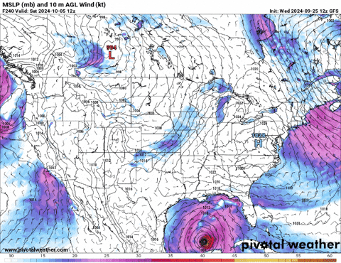
MODEL DATA
There has been plenty of model guidance support for the potential development of a tropical system from during the next seven days. So it isn’t like the NHC is just out here trying to scare people.
But we don’t know if anything will form, and if it forms what it looks like and where it may go if it look slike whatever it looks like.
That is the tough part with these tropical systems.
But here is a general idea given the latest model guidance:


Looking at ensemble guidance there is a trend toward a system forming in roughly the same place and then drifting northwest across the Yucatan and intot he Bay of Campeche, and then…. something else happens. But we don’t know what, it is too far out to know.
There are a few members within the ensemble guidance that do lift this system northward quickly and into the central Gulf, but those are the outlier. While we can’t just ignore them, we have to question their validity a bit given there are so few of them and so many of the others.
Why trust the majority over the minority? In this case, let’s look at the big picture.

The upper-level pattern is aligned similarly to before with a few slight differences. So far, it looks like the ridging near the Bahamas is a bit fatter. This should help guide whatever may be out there a bit more to the west at first. And with that means more land interaction and likely things being a bit slower to develop.
And the slower it develops the more it will tend to drift west with the general flow around the Central American Gyre (CAG). If it stays a bit more offshore and can develop, perhaps we see it clip the Yucatan and plop out north of the peninsula.

But, from that point, there is a bit of a “we don’t know what” may happen next. It will depend on the ridging to the east, the troughing that will be passing across the southern US and the general motion around the CAG.
And then there is the operational guidance. The GFS operational model (which is often the model that produces the scary looking maps that are shared on social media) can decide whether the system is a nothing-burger near MExico, a stout storm in the central Gul, or flips out to sea in the open Atlantic.
The last handful of runs have has so many different outcomes that it simply can’t be trusted with a forecast yet.
So what are we left with? My favorite GIF to use in situations like this:

In short, it looks like “something” may happen, but what we don’t know yet.
THE WATERS
They’re still plenty warm.
I’ve seen a few folks talking about how if a tropical system just formed there, then the waters should be cooler and the next system won’t be as bad.
Sadly, no.
The reality is that with our Climate changing we are trapping more heat at the surface. A majority of that heat is trapped in the ocean because water has a higher Specific Heat than almost anything else.
YOU MAY REMEMBER SPECIFIC HEAT FROM YOUR CHEMISTRY CLASS IN HIGH SCHOOL, IT IS THE AMOUNT OF ENERGY IT TAKES TO CHANGE THE TEMPERATURE OF ONE GRAM OF A THING ONE DEGREE CELSIUS.
And we have spent the last few decades really warming up the waters of the Gulf and Caribbean. And it is more than just the sea surface water temperatures, but the entire depth of the waters. We can measure that by looking at the depth of the “26-degree isotherm” which is where we measure the temperature of the water and see where it drops below 26-degrees Celsius (about 79-degrees Fahrenheit).
As an example, here is what the depth of the 26C isotherm looked like for Hurricane Katrina nearly 20 years ago. Recall that 2005 was anomalously warm in the Gulf and the Loop Current was especially large and warm that year.

Aside from the loop current, the depth of the 26C isotherm was generally between 25- and 50-meters.
Compare that to what the 26C isotherm looks like today:

The average depth is between 40- and 70-meters with two distinct areas of 80-meters or greater depth.
And, if you want to apply this to tropical development, when the water at the surface is cooled down from a passing developing tropical system or from scattered tropical thunderstorms, the now-cooler water sinks down (because, like air, cold water sinks and hot water rises) and is replaced by the warmer water below it. And historically we may be replacing 28C (82 Fahrenheit) water for 26C water. And if we do that fong enough, then we will replace that new 26C water for 24C water.
And 24C water doesn’t really have enough energy to power the development of tropical systems by itself.
But today, it is much different.
Looking at things a little more specifically for the area of potential development, the graphs below show the temperature of the water for a handful of different points. To read these charts you follow each line from the top to the bottom and along the line you can follow the temperatures (the x-axis at the top) with how deep you are (the y-axis on the left).


Looking at the second chart, if we cool down the water at the surface and it sinks, it is replaced by 31C (88 Fahrenheit) water! And if that then sinks, it is replaced by 30C (86 Fahrenheit) water! For a majority of those spots on the map, it takes us down to more than 80 meters before we can start to replace the “cooler” water above with water below 30C.
Back in 2005, most of the Gulf and Caribbean was below 26C at 80 meters depth. Now we are still around 30C.
That is a gargantuan difference. Particularly with developing tropical systems.
It would be hypothesized that it makes it much easier to spin up a Hurricane where we used to instead be looking at a Tropical Depression or Tropical Storm. And that isn’t a very big stretch at all.
FULL CIRCLE & THE BOTTOM LINE
So, we have a very warm Gulf and Caribbean. We have an area of potential development with particularly warm waters—even though a tropical system just passed through. We have model support for the development of a system near the Yucatan during the next seven days. And we have the NHC monitoring the same area.
It’s probably a good time to double-check your hurricane kit. If you live in an area recently impacted by Helene, be sure to restock your kit, assess your situation, and make a plan for what you may need to do if this next system heads your way.
But—and I really want to stress this—we don’t know where this thing may go. No one does. Anyone offering a definitive forecast right now is being rather dishonest. Tropical systems are notoriously difficult to predict at this stage. Small changes in environmental factors can steer these storms in entirely different directions, making certainty impossible at this point.
That’s why it’s not worth worrying yet. We don’t have enough information to make a proper assessment of who may be impacted. However, preparation doesn’t mean panic. It’s simply about staying ahead of any potential risks, so if things do escalate, you’re ready without the stress of last-minute decisions.
In the meantime, stay informed by checking reliable sources like the National Hurricane Center for updates. Preparation is key, even if nothing happens.


The information on isotherm, and the general warmth of the gulf and caribbean sea, was illuminating and interesting. thank you!