For the past couple of weeks, there’s been little to no rain across much of the coastal south. The reason being a strong series of ridges over the southeast, however we may have a slight chance of rain, and unfortunately, it looks like it’ll be on Halloween.
To finish off the weekend, we’ll be fairly dry overall with highs in the upper 80s and the low reaching the upper 50s. It’ll be fairly comfortable tonight if you’re out and about or chilling outside. Starting tomorrow, the cold front will move in keeping conditions dry at least until the end of the day. Behind it, the surface front that’s all the way in Canada will pull Gulf moisture into the Deep South bringing in a wave of humidity for the next several days. It won’t feel like summertime heat per se, but we’ll definitely feel a difference in the feel outside. The somewhat good news is that the temperatures will take a slight dip into the mid 80s for the rest of the week. Winds will shift towards the South as well.

//Courtesy: Pivotal Weather
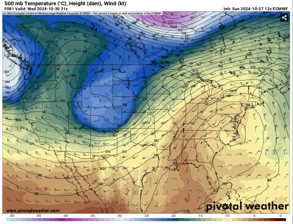
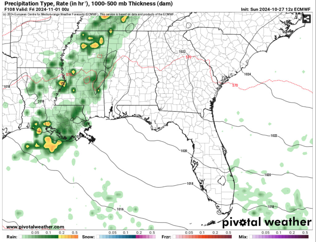
Come Thursday, another cold front will make its way towards the southeast, however it will begin to weaken as it makes it across the eastern Plains. What this means for us is that the front will rain itself out across portions of Tennessee, Arkansas, Louisiana, and Mississippi before it is overtaken by another ridge across the Great Lakes. Most of this rain looks to stay across the Mississippi River Valley, however portions of it will move into parts of central, eastern, and Southeastern Mississippi in the afternoon and remain until Friday. We’ll have to keep an eye on it especially with Halloween plans.

The weekend looks to be similar to the first part of the week as a zone of high pressure takes precedence over the Great Lakes and is filtering in more Gulf moisture into the South bringing humid weather and mid 80s again with lows in the low 60s.

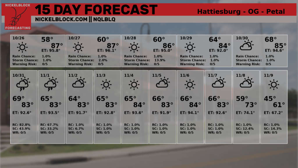
Looking at the 15 day forecast, the humidity will remain for the next almost 2 weeks before another cold front moves into finally cool us down into more fall-like temperatures, just in time for November.
Regional Day-to-Day Forecast
This Afternoon – Sunny, with a high in the upper 80s. Calm wind.
Tonight – Mostly clear, with a low in the mid to upper 50s. Calm wind.
Monday – Patchy fog before 8am. Otherwise, sunny, with a high in the upper 80s. Calm wind becoming south southeast around 5 mph in the afternoon.
Monday Night – Mostly clear, with a low in the low 60s. South wind around 5 mph becoming calm in the evening.
Tuesday – Sunny, with a high in the mid to upper 80s. East southeast wind 5 to 10 mph, with gusts as high as 20 mph.
Tuesday Night – Mostly clear, with a low in the mid 60s. Southeast wind around 5 mph.
Wednesday – Mostly sunny, with a high in the mid 80s. Southeast wind 5 to 15 mph, with gusts as high as 20 mph.
Wednesday Night – Partly cloudy, with a low in the mid 60s. Southeast wind 5 to 10 mph, with gusts as high as 20 mph.
Thursday – A 40 percent chance of showers and thunderstorms in the afternoon. Partly sunny, with a high in the mid 80s. South southeast wind 5 to 10 mph.
Thursday Night – A slight chance of sprinkles. Mostly cloudy, with a low in the low 60s.
Friday – A 20 percent chance of showers or sprinkles. Mostly sunny, with a high in the low to mid 80s.
Friday Night – Partly cloudy, with a low in the low 60s.
Saturday – Sunny, with a high in the mid 80s.

