Okay, so I know Trick-or-Treating may be in jeopardy, so I wanted to take some time to talk through things. Yes, there is a shot for rain on Thursday. Yes, for some folks it will be during Trick-or-Treat hours.
But, I don’t think it will be a total washout for everyone.
Let’s tart things of with the weather tonight: Generally dry, mild and humid. Expect sustained winds around 10 mph with gusts up to 20mph possible, so it’s a good idea to secure any outdoor decorations.
Thursday will bring southwesterly winds aloft, which will pull additional moisture into the area. Although our region will be somewhat removed from the system’s strongest dynamics, models indicate some instability ahead of the front (MLCAPE 500-1000 J/kg), along with modest wind shear (~20 knots). Teh chance for rain will increase from west to east as the front moves in, so keep an eye on conditions if you have outdoor Halloween plans.
Speaking of Halloween plans, here is a timeline for the rain and wind.

So, I’d plan on having an umbrella handy if you’re going to be out walking around and make sure the kiddos know that if it starts to rumble and rain, it is time for a brief break while the weather passes. If you live west of I-59 you have a better shot for rain soaking your Trick-or-Treat plans. And if you live along the I-55 corridor, you are likely looking at a bit of a soggy march from house to house.
The specifics of the timeline is a bit of a quandary. The latest from the HRRR model shows the broken line of messy storms approaching the area around 4p.


But the front is expected to stall on Thursday night into Friday. This means storms may slow down and fall apart as they try to traverse the Pine Belt.
It will also keep rain and thunderstorms in the forecast a bit longer than originally anticipated.
Notice by 8p and 10p (below) the storms have all but stopped moving east and have really fallen apart.


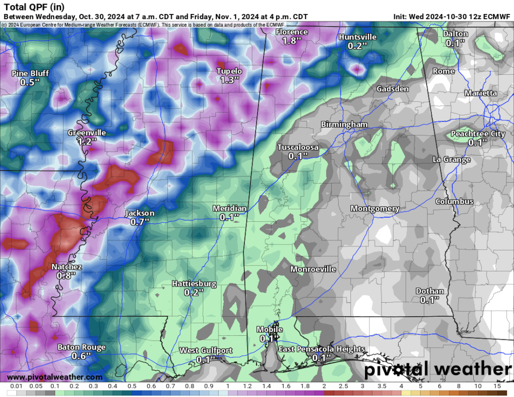
Rainfall totals will be between about 0.25″ and 1.5″ depending on location. Suffice to say this is definitely not a drought buster.

The stalled front will dissipate over the weekend, allowing drier conditions and clearing skies. Highs will remain warm in the low to mid-80s, with nighttime temperatures in the low 60s. Looking ahead, another trough will develop over the Western U.S., bringing a new surface low through the Plains.
This next system is expected to bring another round of rain by Monday night or Tuesday.
REGIONAL DAY TO DAY FORECAST
Tonight: Partly cloudy. Lows in the upper 60s. Southeast winds 5 to 10 mph.
Thursday: Partly sunny. A chance of showers with a slight chance of thunderstorms in the afternoon. Highs in the lower 80s. Southeast winds 10 to 15 mph. Chance of rain 40 percent.
Thursday Night: Mostly cloudy. Lows in the mid 60s. Southeast winds 5 to 10 mph.
Friday: Partly sunny. Highs in the mid 80s. Southeast winds around 5 mph.
Friday Night: Mostly cloudy in the evening, then becoming partly cloudy. Lows in the lower 60s.
Saturday: Mostly sunny. Highs in the mid 80s.
Saturday Night: Partly cloudy in the evening, then clearing. Lows in the lower 60s.
Sunday: Sunny. Highs in the mid 80s.
Sunday Night: Mostly clear. Lows in the mid 60s.
Monday: Passing clouds with an outside shot for rain. Highs in the mid 80s. Chance for rain around 20 percent.
Monday Night: Mostly clear. Lows in the mid 60s.
Tuesday: Mostly sunny. Highs in the mid 80s.

