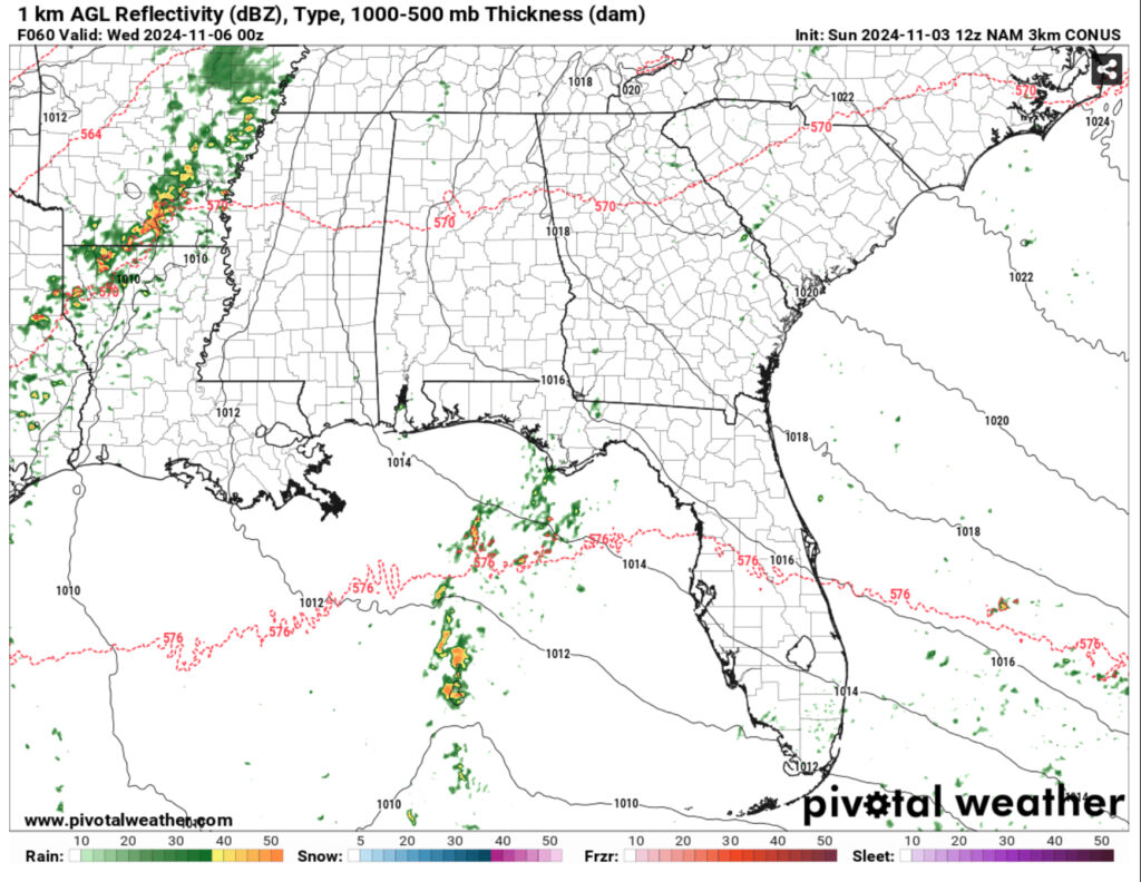
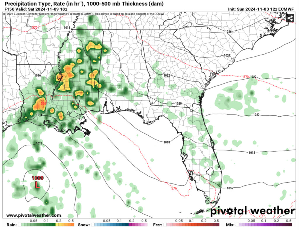
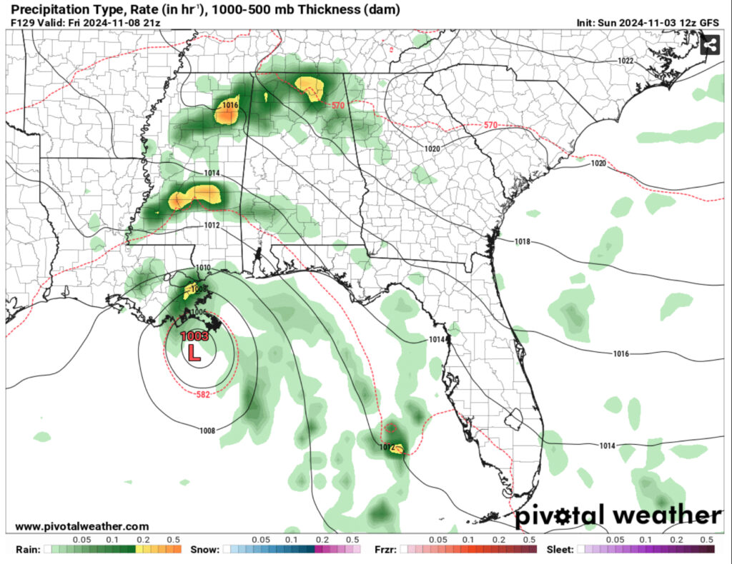
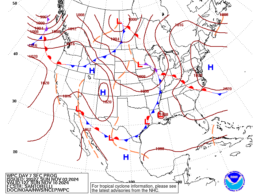
A strong ridge in the Northeast will strengthen over the Atlantic creating a blocking pattern for much of the southeast and Midwest. For those in the eastern Plains and western Midwest, be prepared to see a lot of rain in the next several days as many of the cold fronts that develop will be moved upwards by the gradient wind and mature over that area. For us in the Deep South, that means we won’t get nearly as much as we’d like. On the other side of that coin, we also have something in the tropics to keep our eye on.
Starting at the beginning of the week, we’ll get some low level clouds moving in from the Gulf moisture that will reduce temperatures a bit during the day. However, for the next few days as the gradient develops over the central US, we’ll see some stronger winds pulling from the South bringing gusty conditions into Tuesday. Winds as high as 30mph are possible.

Also on Tuesday, areas of Arkansas and western Louisiana will see some rain and thunderstorms possible over the early afternoon into the evening. Some storms may make it to western Mississippi, however much of eastern Mississippi will see a limited chance going into Tuesday and Wednesday. Around this time is when the cold front begins to stall and tilt a bit more laterally as a strong high pressure system moves in from Canada.
We’ll still see temperatures in the mid to upper 80s for the next several days despite the winds shifting from the south to the east. Around Friday when the cold front begins to stall over the coastal portion of the Deep South is when we’ll see our low temperatures take a slight dive into the low 60s instead of the mid 60s. At this point, we’ll see maybe a slight chance of rain due to the incoming tropical storm.


This weekend is a bit up in the air, no pun intended. Looking at the tropics, the models are in more agreement than yesterday, but the problem is where it will land. The general area so far is between East Texas and the mouth of the Mississippi River in southeast Louisiana. Both the models agree that the Invest will likely fall from hurricane status as it moves into the Gulf since the stream of warm water ends near the middle. The Greater Antilles may have something to be worried about, especially Cuba and Jamaica, as it moves up the Caribbean.
For us in the South, we’ll see the tropical system likely make landfall as a tropical storm. As it moves into the Gulf, areas of Florida and Alabama will likely see rain associated with the storm late in the week, and areas of Louisiana and Mississippi will see some rain from the outer bands before it makes landfall.

One last thing of note is the reason why it will hang out for a bit in the Gulf. Part of this is the stalled cold front I mentioned earlier. This will help with the stalling of the tropical system, however another surface front will mature over the Plains and give enough room for the storm to make landfall.
Regional Day-to-Day Forecast
Tonight – Increasing clouds, with a low in the upper 60s. Southeast wind 5 to 10 mph, with gusts as high as 20 mph.
Monday – Partly sunny, with a high in the low to mid 80s. Southeast wind 10 to 15 mph, with gusts as high as 25 mph.
Monday Night – Partly cloudy, with a low in the mid 60s. Southeast wind 5 to 10 mph, with gusts as high as 20 mph.
Tuesday – Isolated showers. Mostly sunny, with a high in the mid 80s. South southeast wind 5 to 15 mph, with gusts as high as 20 mph. Chance of precipitation is 20%.
Tuesday Night – Partly cloudy, with a low in the mid 60s. South southeast wind around 5 mph becoming calm in the evening.
Wednesday – Partly sunny, with a high in the upper 80s. Calm wind becoming east around 5 mph in the afternoon.
Wednesday Night – Partly cloudy, with a low in the mid 60s. East northeast wind around 5 mph becoming calm.
Thursday – A 10 percent chance of showers. Mostly sunny, with a high in the mid 80s. Northeast wind 5 to 10 mph.
Thursday Night – A 10 percent chance of showers. Partly cloudy, with a low in the mid 60s. Northeast wind around 5 mph.
Friday – A 20 percent chance of showers after noon. Mostly sunny, with a high in the low 80s.
Friday Night – A 20 percent chance of showers. Partly cloudy, with a low in the low 60s.
Saturday – A 20 percent chance of showers. Mostly sunny, with a high in the low 80s.
Saturday Night – Mostly cloudy, with a low around 60.
Sunday – A 20 percent chance of showers. Mostly sunny, with a high in the low 80s.

