We’ve had a much cooler day with overcast skies to start off the week. Tomorrow will be a rainy one with a few rounds of showers making it our way. The SPC has upgraded the severe weather risk for Wednesday to a slight risk (2/5) and the cooldown will follow for Thursday into Friday. Let’s take a look.
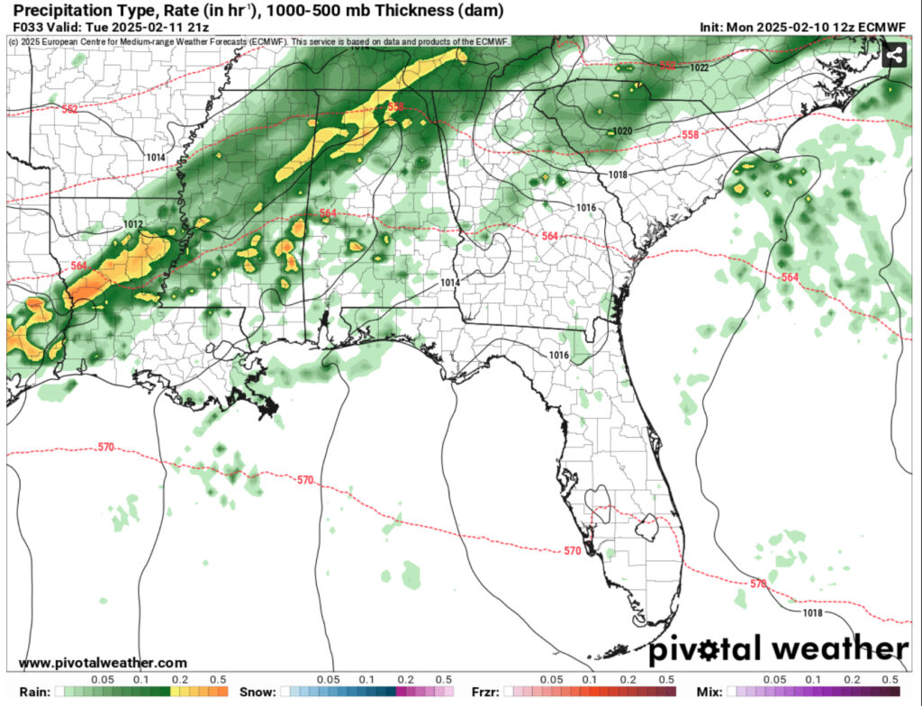
Rolling into tomorrow, we’ll see scattered rain showers in the morning leading to scattered rain and thunderstorms in the afternoon. A steady stream of southwest wind from the surface to the mid-levels along with moisture squeezing from the stationary front will lead to scattered cells in the south and heavier rain in the north. Most of this doesn’t look to be severe, but we should expect some thunder and lighting especially towards the afternoon and evening hours. This will persist into the overnight hours into Wednesday as the surface winds shift towards the south around the Mississippi coastline.
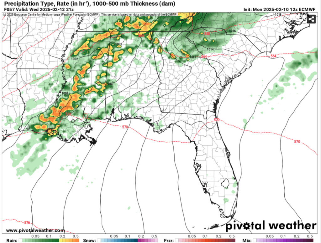
Looking into Wednesday, there is a decent setup for severe weather. The SPC has officially put the Slight risk onto much of south and central Mississippi as well as western Alabama and eastern Louisiana. With the mid-level flow towards the southwest and more southerly flow near the surface, it’s a setup for high winds to come blowing in. Tornadoes can also be likely with this type of setup if we get some cells ahead of the main line. The Euro calls for a much higher chance of severe weather so far, but I wouldn’t doubt we’ll see a couple by the time it reaches us. Hail is also a concern with a decent dry slot in the upper atmosphere.
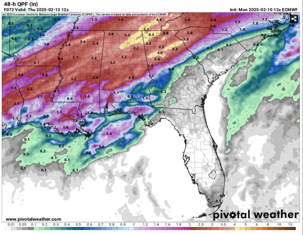
The main line looks to reach us after lunchtime into the mid-afternoon on Wednesday. Since the front is still a bit slow-moving, it’ll hang around until after midnight which will bring us a decent amount of rain. Rainfall totals so far look to be over an inch, but any severe storms may bring more. I’ll have an update on the severe weather on Wednesday, but for now, it looks like a decent chance.
Moving on into Thursday, the front will be mostly out of the way shifting winds northward. We’ll have a brief period of drier air and cooler temperatures in the mid 60s. Bring a windbreaker just in case because winds will be a bit gusty during the day. Overnight, the temperatures will dip into the mid 40s and winds will begin to shift towards the east. Friday will be slightly warmer as the winds shift towards the southeast and temperatures reach the upper 60s. Overnight, the clouds will increase and will hold the heat in keeping the low temps in the 50s.
Regional Day-to-Day Forecast
Tonight – Mostly cloudy, with a low around 55. Calm wind.
Tuesday – Showers likely, mainly in the afternoon. Mostly cloudy, with a high near 80. Light and variable wind becoming south southwest 5 to 10 mph in the morning. Winds could gust as high as 20 mph. Chance of precipitation is 60%. New precipitation amounts of less than a tenth of an inch possible.
Tuesday Night – Showers likely. Mostly cloudy, with a low in the low 60s. South wind 5 to 10 mph. Chance of precipitation is 70%. New precipitation amounts between a tenth and quarter of an inch possible.
Wednesday – A chance of showers, then showers likely and possibly a thunderstorm after noon. Mostly cloudy, with a high near 80. South wind 5 to 10 mph increasing to 10 to 15 mph in the afternoon. Winds could gust as high as 30 mph. Chance of precipitation is 70%. New rainfall amounts between a quarter and half of an inch possible.
Wednesday Night – Showers and possibly a thunderstorm before 3am. Low in the low 50s. South southwest wind 5 to 10 mph becoming north northwest after midnight. Winds could gust as high as 20 mph. Chance of precipitation is 100%. New rainfall amounts between a quarter and half of an inch possible.
Thursday – Isolated showers. Mostly sunny, with a high in the mid 60s. North wind 5 to 10 mph. Chance of precipitation is 20%.
Thursday Night – Isolated showers. Partly cloudy, with a low in the low 40s. North northeast wind around 5 mph. Chance of precipitation is 10%.
Friday – Isolated showers after noon. Mostly sunny, with a high in the upper 60s. Northeast wind around 5 mph becoming east southeast in the afternoon. Chance of precipitation is 10%.
Friday Night – Isolated showers, then scattered showers and thunderstorms after midnight. Mostly cloudy, with a low in the mid 50s. Southeast wind around 5 mph. Chance of precipitation is 30%.
Saturday – Scattered showers and thunderstorms. Mostly cloudy, with a high in the upper 70s. Chance of precipitation is 40%.
Saturday Night – Showers and possibly a thunderstorm. Low in the upper 40s. Chance of precipitation is 80%.
Sunday – Scattered showers. Mostly sunny, with a high in the low 60s. Chance of precipitation is 50%.
Sunday Night – Mostly clear, with a low in the low 30s.
Monday – Sunny, with a high in the mid 50s.


