You read that right, we are getting a bonus BOGO of severe weather this week. Our first round will be today, then again tomorrow, and the third shot will be on Saturday.
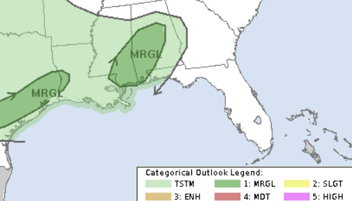
Today’s risk is pretty low. And the main concern is for gusty wind. We hold a MArginal Risk for severe weather through later tonight. This is a “1” on the 1-to-5 scale where a “5” is the highest risk for the most significant severe weather.
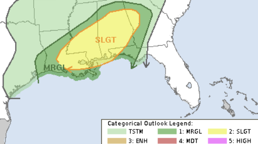
Tomorrow, we bump it up one level to a Slight Risk. That is a ‘2″ on the same 1-to-5 scale.
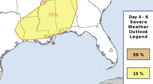
Then on Saturday we are also at a “2” on the same scale.
TIMELINE
Since we are talking about three distinct events, I’ll try to parse things out to help you guys get an idea about each.
TODAY
TIMING CONFIDENCE: Much higher than normal
Today’s risk is pretty straightforward. From the moment you read this through about 9p tonight is when the boundary will be sagging southward and firing off storms. Which means the risk for severe weather should end as we move past 9p. While we can’t rule out a wayward storm here or there, the all intents and purposes, the risk should end by 9p and be over by around 12a.
TOMORROW
TIMING CONFIDENCE: slightly higher than normal
Tomorrow’s risk is a bit more split. I think we may see a brief window in the morning when severe weather will be possible. I think we see a brief window between about 10a and 3p and then a bit of a lull followed by another round of storms between about 6p and 2a.
SATURDAY
TIMING CONFIDENCE: Normal
Saturday’s risk for storms will be between about 6p Saturday night and 6a Sunday morning. Guidance is a bit split on if we will see discrete storms fire up ahead of the line or not. So far, I am leaning toward a bit of a wider window given that I do think we will have those discrete storms out there. If not, storms woudl start up a bit later.
I hesitate to plant a flag in the sand regarding the timeline for Saturday because we still hav ea few days to go and a number of things can change to shake up the timeline.
THREATS
AGain, given that we are talking about three different events, I want to try to break this down into three separate points so I don’t confuse anyone.
TODAY
THREATS CONFIDENCE: Much higher than normal
It looks like brief heavy rain, lightning, wind gusts up to 60mph and some small hail are the biggest concerns tonight.
I don’t think we can rule out a brief ‘minispinny” tornado, but those are often weak (EF-0) and develop and fall apart ithin about 5 minutes and are terribly difficult to predict and track. They can still cause some damage, but aren’t going to flatten homes or uproot and loft trees. These are often the kind that blow down fences, damage windows and roofs, and blow down trees.
TOMORROW
THREATS CONFIDENCE: slightly higher than normal
The main concern for tomorrow is going to be brief heavy rain, lightning, wind gusts up to 70mph, small hail, and the chance for a few tornadoes. And tomorrow, these tornadoes could be up to EF-3 in strength.
As storms develop tomorrow, if we can get discrete, lone storms to form in the warm afternoon and evening air, I would be surprised if we see a few tornado warnings across our area. And, honestly, I wouldn’t be surprised to see a strong tornado tomorrow.
The risk for tornado will continue into the overnight hours. And we may – again – have a risk for a strong tornado given the veer-back-veer look of the hodographs and the DCAPE values over historical thresholds. But I think it will depend on how the broken line of storms orients itself and where storms actually develop relative to each other. And we simply can’t know that quite yet.
Some of you may be wondering, “Do I need to stay up with the storms tomorrow?”
I never quite know how to answer this, because everyone is different. But would say if you don’t feel comfortable with your two reliable methods to get weather alerts (weather radio and an app, for example) then it may be best to hang out with the storms through late evening at the very least to get an idea about how things are looking before you call it a night.
SATURDAY
THREATS CONFIDENCE:Slightly lower than normal
Saturday looks a bit more volatile from a general atmospheric sense, but comes to bat with the same risks (as of today’s data, at least) as tomorrow’s risk: Brief heavy rain, lightning, wind gusts, small hail and tornadoes.
Saturday is going to be another day where we look for the risk for strong tornadoes, too. I tink, given what I’ve seen thus far, EF-3 is the top-end strength we would see based on the data. But that is going to change in the coming days.
Saturday gets tricky because I think there is enough slop in the model data from a “big atmospheric sense” to cast some doubt on how beefy the storms will be. Bit for now, I would prepare for another day of impacts similar to tomorrow, on Saturday.
THE BOTTOM LINE
We will have three shots for storms during the next few days. If you are making plans to be out and about, please keep that in mind. And since there is a chance for some overnight storms, please make sure you have a way to be ‘woken up’ by an alert from the NWS. My app, the NickelBlock Forecasting app, works well as does your NOAA Weather Radio.


Thanks Nick. I appreciate what you do for us.