It looks like the model updates have reduced the chance of rain to just about nothing on Thursday. It’ll be nice to not have some rain in the middle of the week and keep the temperatures fairly steady for the next several days. As we go into meteorological Spring, it’ll feel a lot like Spring as well! As we reach the middle of next week, however, we’ll see the ugly side of Spring which is another chance of severe weather.
Today will be a fine day to be outside as temperatures reach the mid 70s with little wind outside. I would take a walk or just enjoy being outside for a bit because it’s pretty much a perfect day for it. Since it’s a bit cooler at the surface tonight with little wind, expect some radiation fog to build into the early morning hours. Some areas will see denser fog than others, so be careful if you’re driving in it. While the rain chance has diminished, we’ll see some mid and upper level clouds keeping the sun away, but the winds will shift towards the north northwest as the front moves in during the afternoon. Highs will be in the 70s and lows in the 50s.
//Courtesy: Pivotal Weather
Friday will be a pleasant day with a small breeze from the west and a high in the low 70s. There will be few clouds in the sky, so it’ll be a very pleasant day to end off February. The weekend will follow with sunny skies and temperatures in the low to mid 70s during the day and lows in the mid to upper 40s.
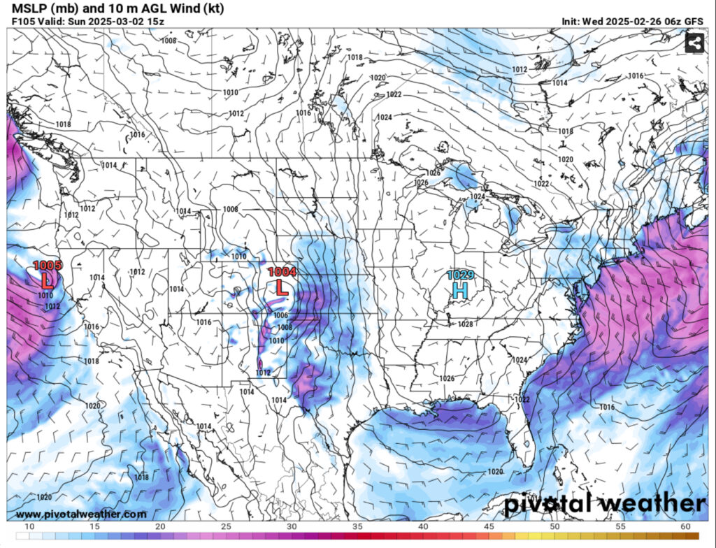
As the beginning of the week approaches, a massive high pressure zone from Canada will preside over the eastern US and move further east as another low pressure zone develops over the Rockies. Temperatures will remain the same, however the upper level clouds will roll in on Monday signifying another front developing. This, however, won’t be our main concern rolling into Wednesday. Another low from Mexico is also developing which will bring us our possible severe weather threat.
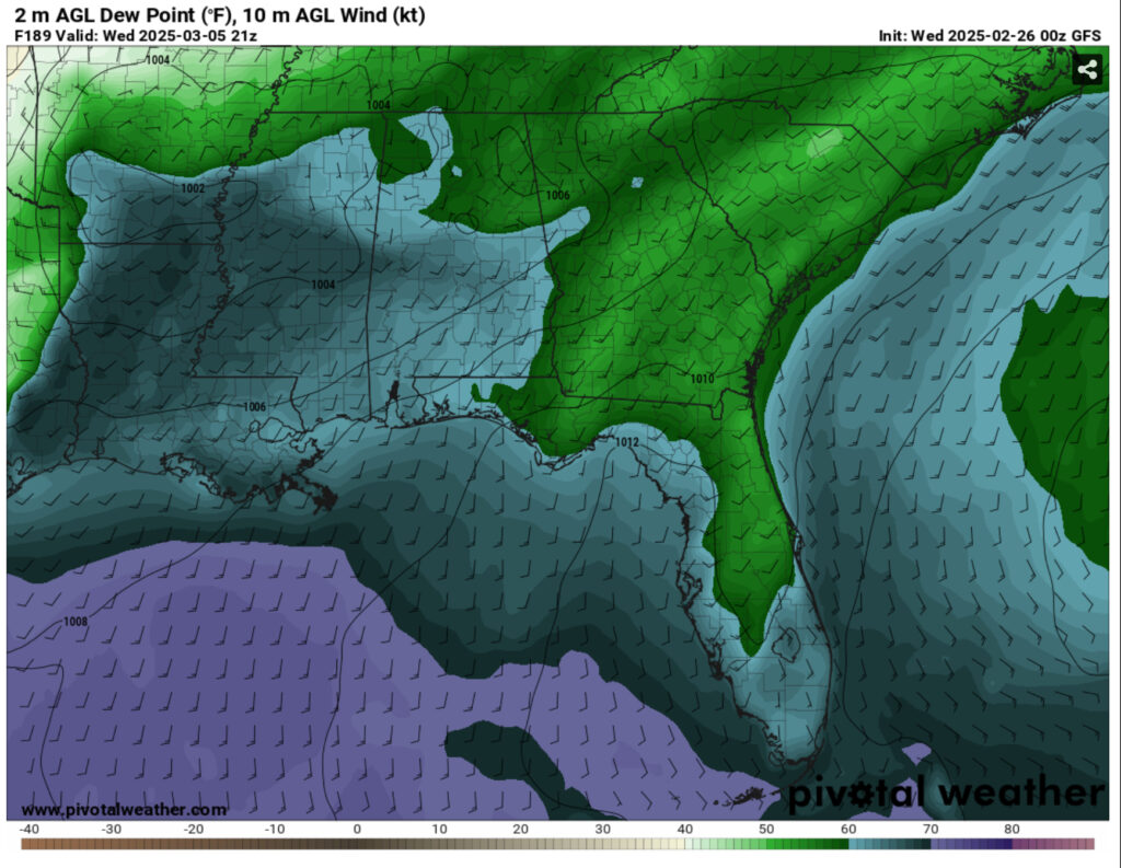
Looking at the moisture inflow, dewpoints reach the upper 60s in parts of eastern Texas and northwestern Louisiana. This, along with convection values over 1000 Joules could spell some severe weather in these areas along with much of eastern Louisiana and western Mississippi. The European model shows the line holding its form as moves further east into parts of central and northeastern Mississippi while the GFS broadens it a bit towards southern Mississippi. The timing of both models is off as well; the European model speedily moves it along by mid-day on Wednesday while the GFS brings it in from the late afternoon to the overnight hours. It looks like the main threats so far would be straightline winds, heavy rain and flash flooding, hail, and a few tornadoes. I’ll update as I see model guidance become more congruent.
Regional Day-to-Day Forecast
Today – Patchy fog before 9am. Otherwise, sunny, with a high in the mid 70s. Calm wind becoming south around 5 mph in the afternoon.
Tonight – Patchy dense fog after 3am. Otherwise, increasing clouds, with a low in the low 50s. South wind around 5 mph becoming calm in the evening.
Thursday – Patchy dense fog before 7am. Otherwise, mostly cloudy, with a high in the low 70s. Light and variable wind becoming north northwest 5 to 10 mph in the morning.
Thursday Night – Mostly cloudy, then gradually becoming clear, with a low in the low 40s. North northwest wind around 5 mph becoming calm in the evening.
Friday – Sunny, with a high in the low 70s. Calm wind becoming west around 5 mph.
Friday Night – Clear, with a low in the mid 40s. Calm wind.
Saturday – Sunny, with a high in the mid 70s. Calm wind becoming west northwest around 5 mph.
Saturday Night – Mostly clear, with a low in the mid 40s. Calm wind becoming northeast around 5 mph.
Sunday – Sunny, with a high in the low 70s. Northeast wind around 5 mph.
Sunday Night – Partly cloudy, with a low in the upper 40s.
Monday – A 20 percent chance of showers. Partly sunny, with a high in the low 70s.
Monday Night – Mostly cloudy, with a low in the upper 40s.
Tuesday – A 30 percent chance of showers. Partly sunny, with a high in the upper 70s.


