We will see a few showers and storms try to develop this afternoon, but for the most part things should remain dry for most folks. If you are unlucky enough to get caught underneath a shower or storm, hang tight for 15-30 minutes, it should pass pretty quickly.
Things ramp up as we move into and through the weekend.
It looks like we will have a shot for storms Friday, Saturday and Sunday across the area. The Storm Prediction Center is even highlighting our area with a Marginal Risk for severe weather on Saturday. That is a “1” on the 1-to-5 scale where a “5” is the highest risk for the most significant severe weather.
But I don’t think it will be a complete washout all weekend.
The first round of rain arrives tomorrow. And it’ll be with us in the afternoon and evening.
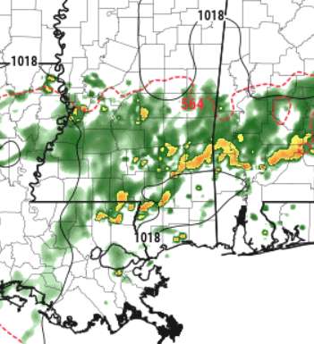
This is why the SPC has issued the Marginal Risk. There may be just enough organization to squeeze out some heavy rain, lightning, gusty wind and hail. n fact, I wouldn’t be surprised if a lot of folks tomorrow see pea to dime sized hail from these storms.
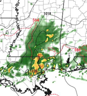
The next round of rain looks to arrive Saturday night – after 7pm.
This batch of storms will likely also need to be pegged with at least a Marginal Risk for severe weather. Again, I think we will see a chance for heavy rain, lightning, gusty wind and hail. But I think this one may also allow for a few tornadoes to form.
That said, any tornado threat would be low and – given the available data – any tornado would be pretty brief and probably weak.
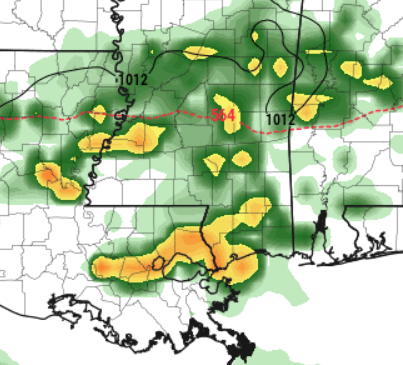
Then Sunday we have another little system breeze by with a quick shot for rain, but probably no storms.
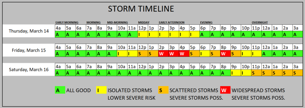
Here is a breakdown on the Storm Timeline
After all of that, we dry out as we move through next week.
REGIONAL DAY TO DAY FORECAST
Today: Partly sunny with a slight chance of showers and thunderstorms in the morning, then mostly cloudy with a chance of showers and thunderstorms in the afternoon. Highs in the upper 70s. Southeast winds 5 to 10 mph. Chance of rain 40 percent.
Tonight: Mostly cloudy. A slight chance of showers and thunderstorms in the evening. Patchy fog after midnight. Lows in the mid 60s. Southeast winds 5 to 10 mph. Chance of rain 20 percent.
Friday: Mostly cloudy with a slight chance of thunderstorms. A slight chance of showers in the morning, then showers likely in the afternoon. Highs in the upper 70s. South winds 5 to 10 mph. Chance of rain 70 percent.
Friday Night: Mostly cloudy with a chance of showers with a slight chance of thunderstorms. Lows in the lower 60s. South winds around 5 mph, becoming west around 5 mph after midnight. Chance of rain 50 percent.
Saturday: Mostly cloudy. A chance of showers with a slight chance of thunderstorms in the afternoon. Highs in the upper 70s. Chance of rain 30 percent.
Saturday Night: Mostly cloudy. A slight chance of showers and thunderstorms in the evening, then a chance of showers and thunderstorms after midnight. Lows in the lower 60s. Chance of rain 40 percent.
Sunday: Showers likely with a chance of thunderstorms. Highs in the lower 70s. Chance of rain 70 percent.
Sunday Night: Mostly cloudy in the evening, then becoming partly cloudy. A slight chance of showers and thunderstorms. Cooler with lows in the lower 50s. Chance of rain 20 percent.
Monday: Mostly sunny. Highs in the upper 60s.
Monday Night: Mostly clear in the evening, then becoming partly cloudy. Cooler with lows in the lower 40s.
Tuesday: Mostly sunny. Highs in the mid 60s.
Tuesday Night: Mostly cloudy in the evening, then becoming partly cloudy. Lows in the mid 40s.
Wednesday: Mostly sunny. Highs around 70.


