We’re in for some unseasonably warm, humid, and breezy weather through Tuesday as southerly winds continue to pull in moisture ahead of a big upper-level system over the central U.S. Expect lots of clouds, a few patchy light showers, and some gusty wind.
By tomorrow, as a cold front gets closer, clusters of showers and thunderstorms will be possible through the morning, mainly in our western areas. There is a small chance for damaging winds or even a brief tornado, but luckily, limited instability should keep the severe weather threat low, and conditions should become less favorable as we head into the afternoon.
But I know everyone is more interested in Tropical Storm Rafael.
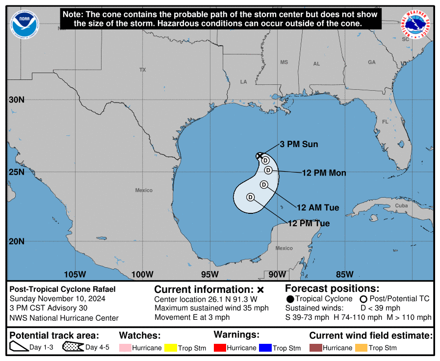
This may look ominous, but the data suggest it may look worse than it may end up actually being.
Rafael is expected to strengthen into a hurricane and head into the southern Gulf of Mexico by midweek. The exact path is still uncertain but it will face wind shear and dry air, so it should weaken before coming closer to the coast. In fact, there is a reasonable chance that it falls apart and limps ashore as a few rainbands and some gusty wind as a Tropical Depression.
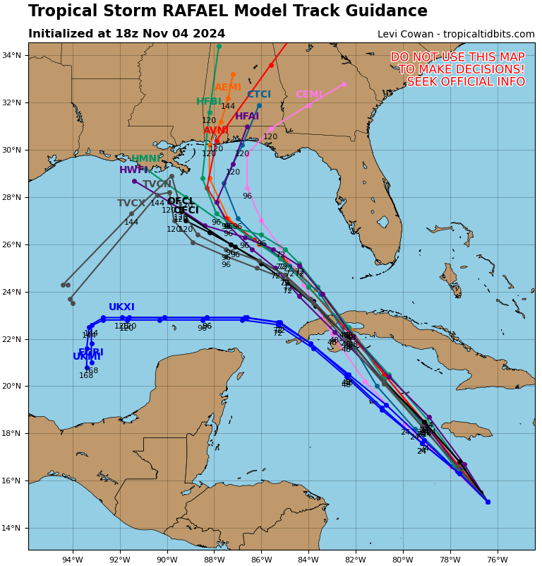
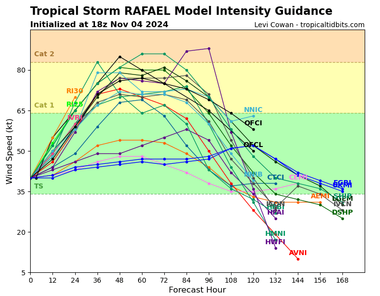
Currently, the model guidance is not handling things very well. Sure, there is a fair amount of agreement across the board through 48 hours from now, but after that things split with some models taking it toward Mexico, other toward the northern Gulf Coast. Then things split again, some taking it more west, others to the east.
Since we don’t know exactly where landfall will be, though, it is tough to pinpoint who will have the highest risk for any impactful weather.
And yeah, even as a Tropical Depression, we may still see some reasonably potent weather. Because the storm may actually be more dangerous if that does happen as it would open the door for a handful of brief “tropical” tornadoes around the region. Those are the tornadoes that form pretty quickly and tend to also move pretty fast and are tough to find on radar. They don’t do nearly as much damage as their Big Brothers in the Winter or Spring, but they can still knock down trees rip off shingles, and blow down fences and destroy barns and sheds.
The timeline right now suggests that late Friday night and through Saturday may be the time period to watch for landfall somewhere nearby – if at all.
RAFAEL NOTES
I’ve heard from a handful of folks about this, so I want to do a little Q& A….
A NOVEMBER HURRICANE?! HAS THIS EVER HAPPENED BEFORE?
It has. You have to go back a way, but back in November of 2009, Hurricane Ida developed in roughly the same region (a bit more south) and traveled almost due north. This peaked in intensity in the waters between the Yucatan and Cuba and then fell apart as it moved toward the northern Gulf coast.
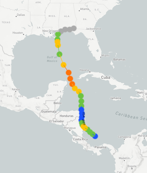
What about before that? In November? Not many times. In fact, there have only been 4 – count ’em! – storms that have impacted our general region in November.
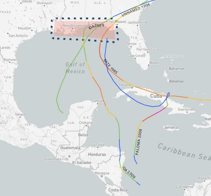
And one fell apart in the Gulf before it even made landfall.
I HAVE OUTDOOR PLANS SATURDAY! HOW SHOULD I PREPARE, NICK?
I would prepare like you were preparing for a line of storms to move through. We are back into our “Fall Severe Weather Season” so you should always have a backup plan for storms. In this case, the timeline would be stretched a few extra hours, but the idea is the same. Rain, wind and the chance fro a few brief tornadoes.
The main difference here is: This one might miss us.
So, I would have a backup plan, but don’t cancel any plans yet, if possible. Continue to monitor the forecast and wait until we have a better feel for how things may shake out. .
COULD IT BE LIKE KATRINA?
Highly unlikely. That was in August, with a very warm Gulf, under a big ridge, with all of the right ingredients in place.
This is November, the Gulf isn’t as warm as it is in August. It is currently about 2F to 4F cooler than it was during Katrina – and that is a big difference. There is no big upper level ridge, instead we will have passing cold fronts during the next few days. And – quite literally – none of the right ingredients are in place.
REGIONAL DAY TO DAY FORECAST
Tonight: Mostly clear. Lows in the mid 60s. Southeast winds 5 to 10 mph with gusts up to 20 mph.
Tuesday: Mostly sunny. A slight chance of showers in the afternoon. Highs in the mid 80s. Southeast winds 10 to 15 mph. Chance of rain 20 percent.
Tuesday Night: Partly cloudy in the evening, then becoming mostly cloudy. Lows in the upper 60s. Southeast winds around 5 mph.
Wednesday: Partly sunny with a slight chance of showers. A slight chance of thunderstorms in the afternoon. Highs in the lower 80s. East winds around 5 mph. Chance of rain 20 percent.
Wednesday Night: Mostly cloudy with a slight chance of showers and thunderstorms. Lows in the upper 60s. Northeast winds around 5 mph. Chance of rain 20 percent.
Thursday: Mostly cloudy with a 20 percent chance of showers. Highs in the lower 80s.
Thursday Night: Mostly cloudy with a 20 percent chance of showers. Lows in the upper 60s.
Friday: Mostly cloudy. A slight chance of showers in the morning, then a chance of showers with a slight chance of thunderstorms in the afternoon. Highs around 80. Chance of rain 40 percent.
Friday Night: A slight chance of thunderstorms in the evening. Mostly cloudy with a chance of showers. Lows in the upper 60s. Chance of rain 30 percent.
Saturday: Mostly cloudy with a chance of showers with a slight chance of thunderstorms in the morning, then partly sunny with a chance of showers in the afternoon. Highs in the lower 80s. Chance of rain 40 percent.
Saturday Night: Partly cloudy in the evening, then becoming mostly cloudy. A 20 percent chance of showers. Lows in the mid 60s.
Sunday: Mostly sunny with a 20 percent chance of showers. Highs in the lower 80s.
Sunday Night: Partly cloudy. Lows in the lower 60s.
Veterans Day: Mostly sunny. Highs around 80.

