Overall, a quiet stretch of weather is expected across the region through next Monday, with the only notable disturbance arriving Thursday evening. In fact, tonight will probably be the coldest night we will see for a long time. Soak it up!
High pressure will remain in control through tomorrow night, keeping conditions dry and pleasant. Winds will turn southerly by tomorrow, though, allowing moisture to slowly return and temperatures to gradually moderate.
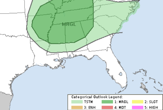
Highs will climb into the 70s Wednesday, with some lower 80s possible south of I-20 by Thursday. A cold front will approach Thursday night, bringing a chance for showers and storms — mainly north of I-20 — with a marginal risk for isolated severe storms, including damaging wind gusts and quarter-sized hail.
While we can’t rule out a chance for a storm here or there on Thursda ynigth across our area, the risk for severe weather looks pretty low. This activity will clear out early Friday, followed by a drier airmass and cooler temps into the weekend.
Moisture returns again by Monday, with another warming trend expected to kick off the new week.
REGIONAL DAY TO DAY FORECAST
Tonight: Clear. Lows in the lower 40s. North winds around 5 mph.
Wednesday: Sunny. Highs in the mid 70s. Northeast winds around 5 mph, becoming northwest in the afternoon.
Wednesday Night: Clear. Lows around 50. South winds around 5 mph in the evening, becoming light and variable.
Thursday: Patchy fog in the morning. Mostly Sunny. Highs in the lower 80s. Southwest winds 5 to 10 mph.
Thursday Night: Passing clouds north. Can’t rule out a storm. Lows in the mid 50s. Chance for rain under 20 percent.
Friday: Sunny. Highs in the upper 70s.
Friday Night: Clear. Lows in the upper 40s.
Saturday: Sunny. Highs in the lower 70s.
Saturday Night: Clear. Lows in the mid 40s.
Sunday: Sunny. Highs around 80.
Sunday Night: Clear. Patchy fog after midnight. Lows in the mid 50s.
Monday: Patchy fog in the morning. Sunny. Highs in the mid 80s.


