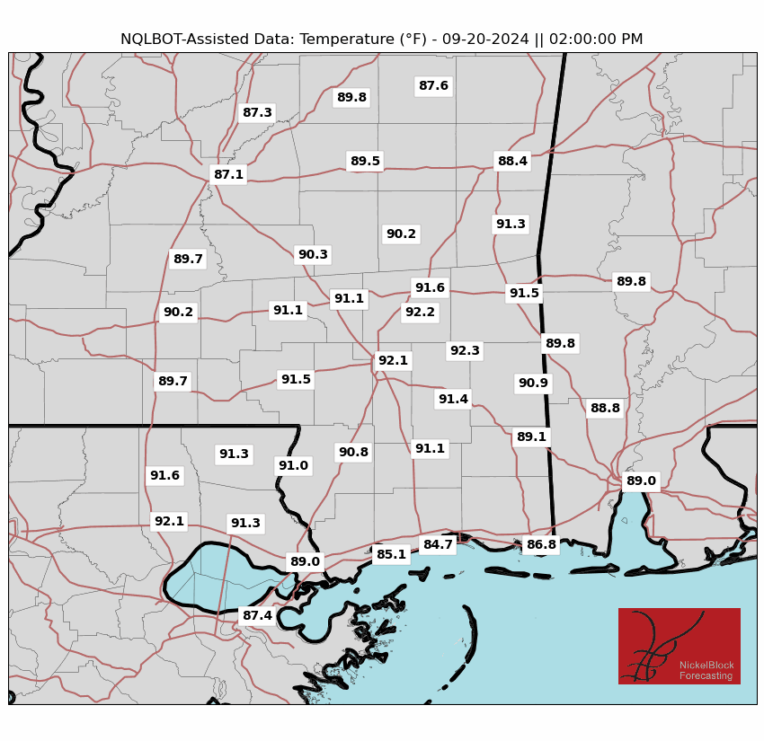
No major changes to the forecast since yesterday. High pressure is building into the area and we are set to stay mostly dry until Thursday. Temperatures will hang around in the upper 80s.
By Thursday, we will start to see a plume of tropical moisture ooze back into the area. I think this should do a good job to give us a boost in the shot for rain. That said, I think most of it will be south of I-20 and much of the meaningful rain will fall closer to the coast. That will linger into Friday, but I think most of the action will ease off by the evening hours on Friday, which means most of the football games should kickoff with no big issues.
Aside from that, we will be monitoring what is happening in the tropics. All the riff-raff out toward Africa won’t be bothering us, but the little area of concern near the Yucatan is still festering.
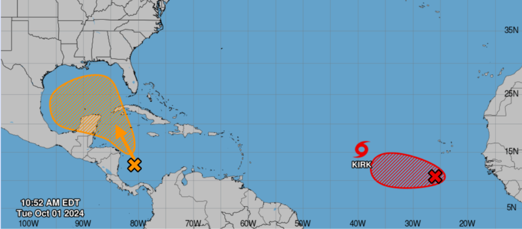
Model guidance is still a bit torn on what happens with this area – but that is normal when all we have is a disorganized area of clouds and showers. Originally model guidance was suggesting that, by now, we would see some sort of organization starting. But that has not happened yet.
Here is the latest from the NHC:
1. Northwestern Caribbean Sea and Gulf of Mexico:
Disorganized showers and thunderstorms located over the southwestern Caribbean Sea are associated with a trough of low pressure.  Environmental conditions could support some gradual development of this system, and a tropical depression could form towards the end of this week or this weekend while it moves generally northwestward over the northwestern Caribbean Sea and into the Gulf of Mexico. Interests along the U.S. Gulf Coast should continue to monitor the progress of this system.
* Formation chance through 48 hours...low...10 percent.
* Formation chance through 7 days...medium...40 percent.
So, it may be another few days.
REGIONAL DAY TO DAY FORECAST
Today: Sunny. Highs in the upper 80s. North winds 5 to 10 mph.
Tonight: Mostly clear. Lows in the mid 60s. North winds around 5 mph.
Wednesday: Sunny. Highs around 90. Northeast winds 5 to 10 mph.
Wednesday Night: Partly cloudy in the evening, then clearing. Lows in the upper 60s. North winds around 5 mph.
Thursday: Mostly sunny with a slight chance of showers. A slight chance of thunderstorms in the afternoon. Highs in the upper 80s. East winds around 5 mph. Chance of rain 40 percent.
Thursday Night: Mostly cloudy with a chance of showers with a slight chance of thunderstorms. Lows around 70. Chance of rain 30 percent.
Friday: Mostly cloudy. A chance of showers with a slight chance of thunderstorms in the morning, then showers likely with a chance of thunderstorms in the afternoon. Highs in the mid 80s. Chance of rain 60 percent.
Friday Night: Mostly cloudy. A slight chance of showers and thunderstorms in the evening. Lows in the upper 60s. Chance of rain 20 percent.
Saturday: Partly sunny. A chance of showers with a slight chance of thunderstorms in the afternoon. Highs in the mid 80s. Chance of rain 20 percent.
Saturday Night: Mostly cloudy. Lows in the upper 60s.
Sunday: Partly sunny. Highs in the mid 80s. Chance of rain 20 percent.
Sunday Night: Mostly cloudy. Lows in the mid 60s.
Monday: Mostly sunny. Highs in the mid 80s.


