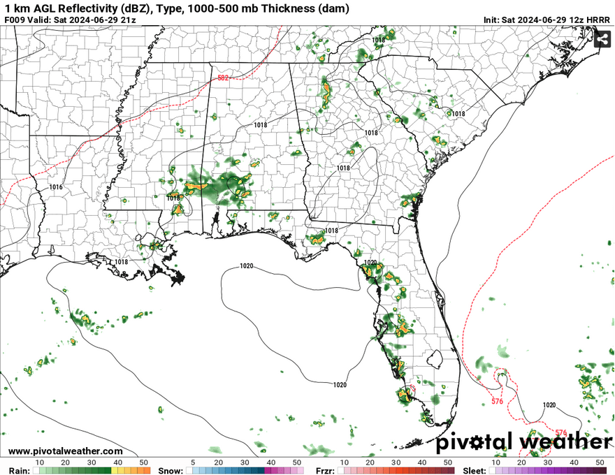
I hope everyone is having a good weekend so far! Right now, there are plenty of scattered thunderstorms across central and southern MS/AL/LA moving northeast. We have plenty of southwesterly flow and southerly flow to bring in moisture and spark up some thunderstorms this early in the day. This will continue on into the evening with a few more storms especially closer to the coastline.
This afternoon, any areas that don’t see some sort of thunderstorm activity will at least see some more cloudy skies which keeps the temperature down slightly. This won’t help a lot considering the increase in humidity, but it will at least keep the UV index down a bit. Scattered thunderstorms will be prevalent throughout the afternoon into the evening with storms beginning to wane and move further towards the coast. Temperatures will reach up to 90 in most areas with the heat index reaching the low to mid 100s in areas that don’t see much cloud cover.

Tomorrow, thunderstorms will be slightly more organized as a stalling front moves further into the mid-South. Low and mid-level northerly flow will help to drive some cool air to spark some thunderstorms during the afternoon and move south into our neck of the woods. Most of the heavier stuff looks to reach central Alabama and Mississippi, however we may still see some scattered thunderstorms south of I-20 by the time the sun goes down. Areas of southeastern Louisiana and coastal Mississippi may see some thunderstorms during the afternoon as well. Temperatures will climb back into the low/mid 90s with heat indices reaching the mid 100s yet again.
To start off the week, we’ll go back to our more normal daily heat regimen with temperatures reaching the mid-90s. Winds will shift to the north as the stationary front moves towards the coast which will impede most rain chances north of the Pinebelt. So prepare for hot weather with a slight breeze.
Stay cool and keep an umbrella with you during the weekend!
Select Data Set:

Regional Day-to-Day Forecast
This Afternoon – Scattered showers and thunderstorms during the day. Partly sunny, with a high in the upper 80s/low 90s. Heat index values as high as 102. Southwest wind 5 to 10 mph. New rainfall amounts between a tenth and quarter of an inch, except higher amounts possible in thunderstorms.
Tonight – A chance of showers and thunderstorms before midnight. Mostly cloudy, then gradually becoming mostly clear, with a low in the mid 70s. South wind around 5 mph becoming calm.
Sunday – Showers and thunderstorms likely in the afternoon. Patchy fog before 8am. High in the mid 90s. Heat index values as high as 106. Calm wind becoming northwest around 5 mph. New rainfall amounts between a tenth and quarter of an inch, except higher amounts possible in thunderstorms.
Sunday Night – A slight chance of showers and thunderstorms before sunset. Patchy fog after 1am. Otherwise, partly cloudy, with a low in the mid 70s. Calm wind.
Monday – Scattered thunderstorms possible in the afternoon. Mostly sunny, with a high in the mid 90s. Calm wind becoming north northeast around 5 mph in the morning. New rainfall amounts of less than a tenth of an inch, except higher amounts possible in thunderstorms.
Monday Night – A chance of isolated thunderstorms in the evening. Partly cloudy, with a low in the mid 70s. Calm wind.
Tuesday – A chance of showers and thunderstorms in the afternoon. Mostly sunny, with a high in the mid 90s. Calm wind becoming southeast around 5 mph in the afternoon.
Tuesday Night – Isolated thunderstorms possible in the evening. Partly cloudy, with a low in the mid 70s. South southeast wind around 5 mph becoming calm in the evening.
Wednesday – A chance of scattered thunderstorms in the afternoon. Mostly sunny, with a high in the mid 90s. Calm wind becoming south southeast around 5 mph in the morning.
Wednesday Night – Mostly clear, with a low in the mid 70s.
Independence Day – A chance of showers and thunderstorms. Mostly sunny, with a high in the mid 90s.
Thursday Night – A slight chance of showers and thunderstorms. Mostly clear, with a low in the mid 70s.
Friday – A slight chance of showers and thunderstorms. Sunny and hot, with a high in the upper 90s.


