After the stormy morning we all had, it’s nice to see the sun again, albeit it might be a little sticky outside. The rest of the week will be quite warm with temperatures remaining in the 80s for most of the week. Not only that, we’ll have a chance of storms late Friday night as a predecessor for the possible severe weather on Sunday.
Starting off tonight, we’ll have some patchy dense fog across the area with the winds dying down and temperatures much cooler than the upper atmosphere. Be careful if you’re driving tonight and into the morning hours as it’ll be until the mid-morning that it dissipates. Lows will be in the mid 50s. Rolling into Tuesday, the clouds will move out and bring us some sunnier skies with highs in the low 80s and less humid conditions during the day. Overnight, we’ll dip back into the mid 50s with nary a cloud in the sky.
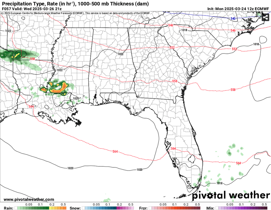
So far, both the GFS and European model are showing a rogue storm moving in from the northwest Wednesday afternoon into the evening. The National Weather Service in New Orleans has mentioned a short timed event for storms, so areas in southwestern Mississippi as well as the Pinebelt may see some of this. The storm looks to be elevated towards the mid and upper levels which means that it could just be a heavy rain event with a possible thunderstorm. Highs will be in the low 80s and lows in the mid 50s. Thursday will be about the same in terms of temperatures with more clouds rolling in towards the evening.
Friday will be a different picture with more clouds in the sky, likely some mid level and eventually low level cumulus clouds. The winds will shift to the south southeast and will be gusting up to 25mph due to a gradient thanks to the surface high moving towards the Atlantic. We’ll reach the low 80s again during the day, however we’ll see some rain and scattered thunderstorms by the time the system moves east during the overnight hours. Overnight, we’ll see the low reach the mid 50s.
Ladies and Gentlemen, the Weekend
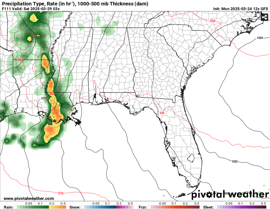
Unfortunately for us, this looks to be another stormy weekend as we’ll have rain chances both Saturday and Sunday. Saturday looks to be some scattered thunderstorms during the day with a possible strong one, however the threat looks to be much further northwest of us. Temperatures will top out around 80 during the day with south southeast winds.
If you’ve looked at Nick’s Facebook page, he’s already highlighted the SPC’s forecast for Sunday, and it is b r o a d. It encapsulates much of the South to the Great Lakes region. The reason being is an ejecting upper level shortwave trough that will move through the northern Great Lakes. The severe weather forecast is a bit dicey right now since we’re so far out and models both show a similar story in terms of the movement of this system, but not in the severity. Since we’re at the tail end (quite literally) of this system, it could go one of two ways. Either we see only a few storms or more of a severe weather risk. I know that sounds like a cop-out, but the models are still grasping at anything right now until the event comes closer. The main concern with this system is the mid 60s dewpoints meaning that there’s a good amount of moisture inflow towards our region. The simulated radar also shows some potent storms developing, however the threat looks mostly like hail and heavy rain right now. I’ll keep you posted on Wednesday.
Select Data Set:

Regional Day-to-Day Forecast
Tonight – Patchy dense fog after 4am. Otherwise, mostly cloudy, with a low in the mid 50s. South wind around 5 mph becoming calm in the evening.
Tuesday – Areas of dense fog before 9am. Otherwise, mostly cloudy, then gradually becoming sunny, with a high in the low 80s. Calm wind becoming west northwest around 5 mph in the afternoon.
Tuesday Night – Clear, with a low in the mid 50s. Calm wind.
Wednesday – Mostly sunny, with a high in the low 80s. Some isolated storms possible in the afternoon. Calm wind becoming north northeast around 5 mph in the morning.
Wednesday Night – Partly cloudy, with a low in the low 50s. North northeast wind around 5 mph becoming calm.
Thursday – Mostly sunny, with a high in the low 80s. Southeast wind around 5 mph.
Thursday Night – Mostly cloudy, with a low in the mid 50s. South southeast wind around 5 mph becoming calm in the evening.
Friday – Partly sunny, with a high in the low 80s. South southeast wind 5 to 15 mph, with gusts as high as 25 mph.
Friday Night – A 20 percent chance of showers and thunderstorms after 1am. Mostly cloudy, with a low in the low 60s. South southeast wind 5 to 10 mph, with gusts as high as 20 mph.
Saturday – A 50 percent chance of showers and thunderstorms. Mostly cloudy, with a high around 80.
Saturday Night – A 20 percent chance of showers. Mostly cloudy, with a low in the low 60s.
Sunday – A 40 percent chance of showers and thunderstorms. Partly sunny, with a high in the low to mid 80s.
Sunday Night – A 20 percent chance of showers and thunderstorms. Partly cloudy, with a low around 60.
Monday – A 30 percent chance of showers. Mostly sunny, with a high near 80.


