It’s been quite a relief to have some cooler conditions across the southeast for the middle of April. We won’t see too much of a drastic change in temperatures, but we’ll have some dips and rises due to the change in winds from a few fronts coming in.
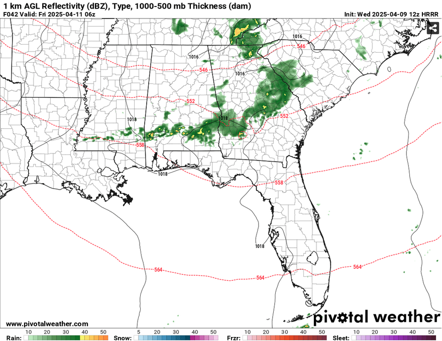
Today we’ll see winds fairly calm and plenty of sunshine. Highs will be in the mid 70s and conditions will be quite pleasant. Tonight we’ll reach the upper 40s with clear skies. Thursday will be a bit warmer due to the change in wind direction. Highs will be in the low 80s with winds out of the southwest. This won’t last long as a low pressure system moves further south into the lower Appalachians bringing some showers and thunderstorms with it. Areas north of Highway 82 may see some isolated severe storms, however as the front moves further south, the moisture flow begins to cut off, so we may see a few storms south of I-20 and almost none by the time it reaches the coast early Friday morning. Areas of southern Alabama may see a higher chance for some storms before it reaches the coastline in the early morning.
Due to the front, we’ll have a gusty day on Friday with northwest winds gusting up to 25mph. Highs will be in the mid 70s and lows in the upper 40s. We’ll have a great start to the weekend with sunny skies across the south and highs in the low 70s on Saturday. We’ll have some slight north winds, but Saturday will be your day to be out and about or taking care of the yard. Sunday morning will be in the mid 40s before the winds shift south again and we get a high in the low 80s. Thankfully, the relative humidity will be pretty low, so it’ll be more of a “dry” heat.
Monday will be slightly more humid as we have our high exiting to the east and another front moving in with a similar setup to Friday’s. There’s a decent amount of moisture in the air, however the flow begins to die out by the time it gets past I-20, so expect some isolated showers and storms during the day on Tuesday, but this will be a fairly slim chance. The cold front will be right behind it, so expect a change in conditions and some cooler, windier air. Wednesday will be another clear day with temperatures in the low 70s and clear skies.
Select Data Set:

Regional Day-to-Day Forecast
This Afternoon – Sunny, with a high in the mid 70s. North northwest wind around 5 mph becoming calm.
Tonight – Clear, with a low around 50. Calm wind.
Thursday – Sunny, with a high in the low 80s. Calm wind becoming west southwest around 5 mph in the morning.
Thursday Night – Mostly clear, with a low in the mid 50s. Slight chance of rain and thunderstorms in the early morning hours. Southwest wind around 5 mph becoming northwest after midnight.
Friday – Sunny, with a high in the mid 70s. Northwest wind 5 to 10 mph increasing to 10 to 15 mph in the afternoon. Winds could gust as high as 25 mph.
Friday Night – Clear, with a low in the upper 40s. North wind 5 to 10 mph, with gusts as high as 20 mph.
Saturday – Sunny, with a high in the low 70s. North wind 5 to 10 mph.
Saturday Night – Clear, with a low in the mid 40s. North northwest wind around 5 mph becoming calm.
Sunday – Sunny, with a high in the low 80s. Calm wind becoming south southwest around 5 mph.
Sunday Night – Clear, with a low in the mid 50s.
Monday – Sunny, with a high in the mid 80s.
Monday Night – Partly cloudy, with a low in the upper 50s.
Tuesday – Partly sunny, with a high in the low 80s. Slight chance of rain and thunderstorms.


