This multi-day mini heat wave is expected to continue through the end of the week, with high temperatures in the mid to upper 90s and heat indices exceeding 110F, especially west of Interstate 55 and into the Pine Belt.


Given the heat is accompanied by high humidity, we may see another round of afternoon storms. I will say that yesterday’s rain was a bit more robust than expected, we will see if we can’t do that again — especially for folks who desperately need some water.
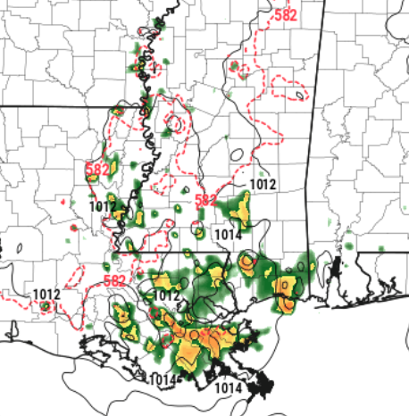
The HRW-ARW model – which tends to overshoot rain chances a bit – is showing pretty widely scattered storms. I don’t often use this model, but given that we “overshot” the rain yesterday a bit, I figure it was worth a look today. Notice, though, that most of the rain is tied up across parts of southeastern Louisiana.
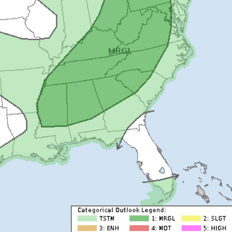
This isn’t our only shot for rain. A cold front will approach the area by Saturday giving us a shot for some strong storms with gusty wind. The STorm Prediction Center has highlighted part of the area with a Marginal Risk for severe weather.
By Sunday, the front is expected to push southward, bringing drier and slightly cooler air, leading to lower humidity and slightly more comfortable mornings for a few days before we start to warm back up.
REGIONAL DAY TO DAY FORECAST
Today: Mostly sunny. A chance of showers and thunderstorms this afternoon. Highs in the mid 90s. North winds around 5 mph. Chance of rain 30 percent. Heat index values up to 108.
Tonight: Partly cloudy with a chance of showers and thunderstorms in the evening, then mostly clear after midnight. Humid with lows in the mid 70s. South winds around 5 mph in the evening, becoming light and variable. Chance of rain 30 percent.
Friday: Mostly sunny. A slight chance of showers and thunderstorms in the morning, then a chance of showers and thunderstorms in the afternoon. Humid with highs in the lower 90s. Southeast winds around 5 mph. Chance of rain 20 percent. Heat index values up to 106.
Friday Night: Partly cloudy in the evening, then clearing. Humid with lows in the lower 70s. South winds around 5 mph in the evening, becoming light and variable.
Saturday: Sunny. A chance of showers and thunderstorms in the afternoon. Humid with highs in the mid 90s. South winds around 5 mph. Chance of rain 40 percent. Heat index values up to 105.
Saturday Night: Mostly clear. A slight chance of showers and thunderstorms in the evening. Lows in the lower 70s. Chance of rain 20 percent.
Sunday: Sunny. A chance of showers and thunderstorms in the afternoon. Highs in the mid 90s. Chance of rain 40 percent. Heat index values up to 110.
Sunday Night: Mostly clear. A chance of showers and thunderstorms, mainly in the evening. Lows in the lower 70s. Chance of rain 40 percent. Heat index values up to 105 early in the evening.
Monday: Sunny. A slight chance of showers and thunderstorms in the afternoon. Highs in the mid 90s. Chance of rain 20 percent.
Monday Night: Clear. Lows in the upper 60s.
Tuesday: Sunny. Highs in the mid 90s.
Tuesday Night: Clear. Lows in the upper 60s.
Wednesday: Sunny. Highs in the mid 90s.
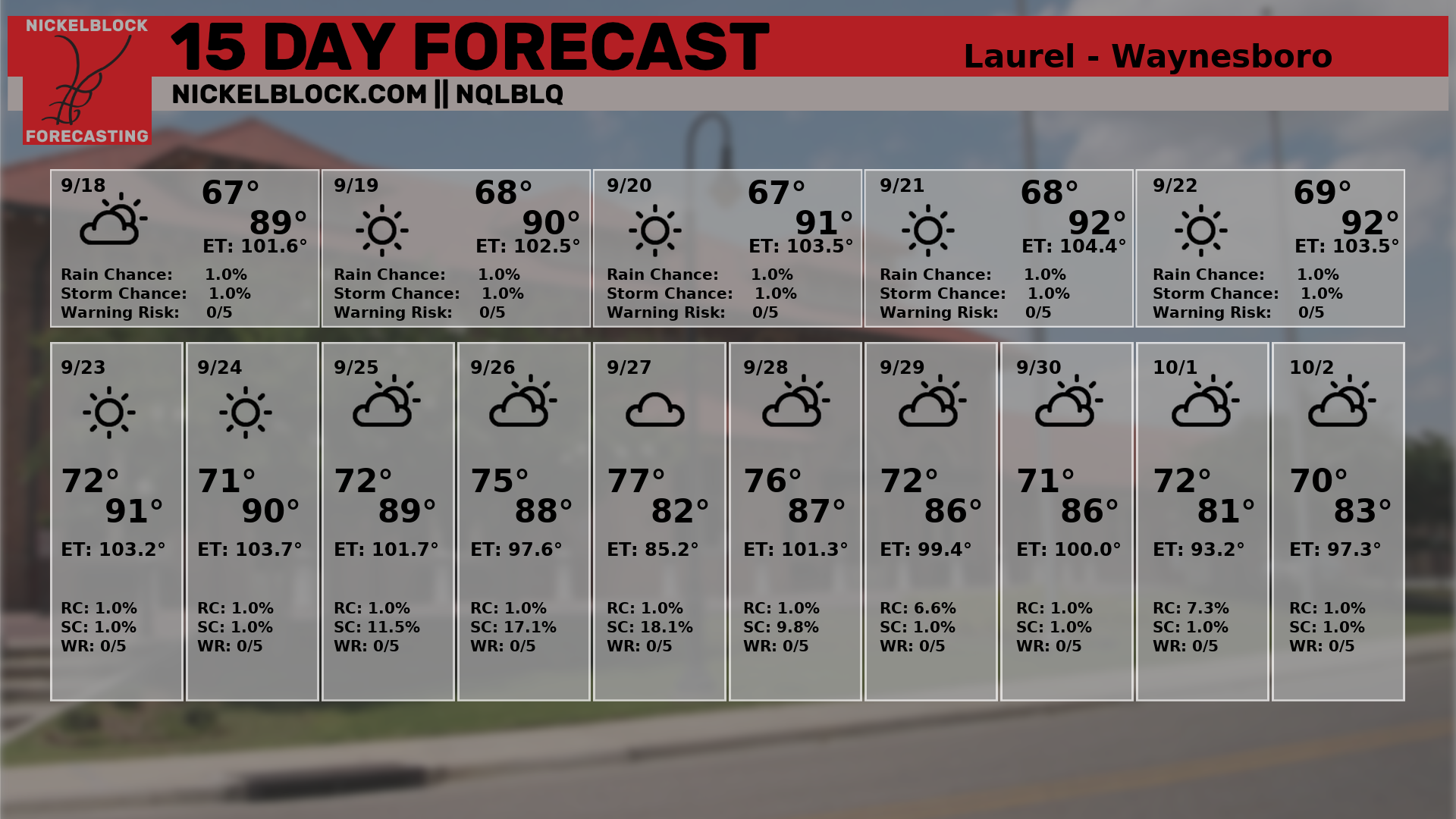
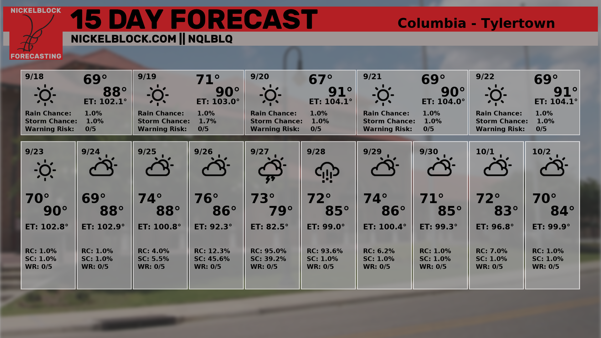
15-DAY FORECAST
Looking at the 15-day forecasts from NQLBOT, our AI weather helper, it looks like things will remain warm through the next week. Things may cool down slightly by next weekend, but thats about it. There is a bit of a “fake out” cool down around the 25th of the month. I don’t buy that. I think our AI weather friend ate some bad data for breakfast!


Thanķ you Nick. Wishing you the best.