It looks like it is shaping up to be a nice Monday. We may see a few showers this afternoon here and there, but overall, things should stay dry for almost everyone.
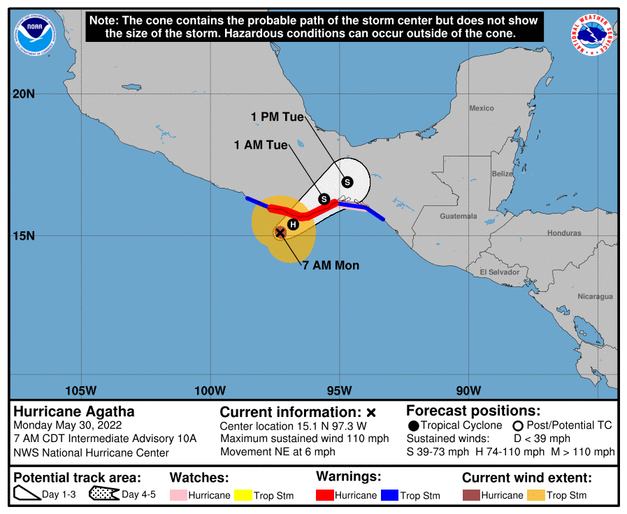
That leaves plenty of time to keep tabs on what may – or may not – happen with Hurricane Agatha in the Pacific.

The National Hurricane Center is still monitoring the system for two reasons. The impacts to Mexico as it makes landfall as a Category 2 Hurricane and the chance that pieces of it drift across Mexico, guatamala, and Belize and end up in the Gulf of Caribbean.

Near the Yucatan Peninsula:
A large and complex area of low pressure is expected to develop across Central America, the Yucatan Peninsula, and the southwest Gulf of Mexico in a few days, partially related to the remnants of Hurricane Agatha from the eastern Pacific. Some gradual development is possible within this system in the far southwest Gulf of Mexico around mid-week or in the northwest Caribbean by the latter part of this week as it drifts eastward or Northeastward. Regardless of development, locally heavy rains will be possible across southern Mexico, the Yucatan Peninsula, Guatemala, and Belize through the week.
— Formation chance through 48 hours…low…near 0 percent.
— Formation chance through 5 days…medium…40 percent.
So far, it doesn’t look like this will be much of a concern to the northern Gulf Coast, but instead for places to the east.
The Data
Model guidance seems to be in pretty good agreement that Agatha will get dragged across southern Mexico and toward Guatemala and Belize.

After that point, the consensus between 0 he models is that it will continue to move east(ish) and stay generally away from the northern Gulf Coast. And the likelihood that the model guidance changes, allowing whatever is out there to lift northward is very low.

As high pressure at the surface takes over, there will also be some reasonable northwest wind up around 500mb, as well as some west-to-east shear up around 300mb across the central and southern Gulf. That should do a good job to (A) block anything from moving north and (B) eat anything that tried.
We win. Twice!
So while the NHC is monitoring the area for development, you can rest easy knowing that , as of now, there isn’t much data to support it getting very organized, nor much data to support it moving north.
That leaves plenty of time to monitor the warm weather and afternoon storms that will be possible each day for the next seven days as high pressure settles in across the region.
Day to Day Forecast
Today
Mostly sunny with a 10-percent chance for an afternoon storm. Highs around 90.
Tonight
Mostly clear. Lows in the upper 60s.
Tuesday
Mostly sunny with a 30-percent chance for a storm. Highs in the upper 80s.
Tuesday Night
Mostly clear. Lows in the upper 60s.
Wednesday
Mostly sunny with a 20-percent chance for storm. Highs in the lower 90s.
Wednesday Night
Partly cloudy. Lows in the upper 60s.
Thursday
Sunny. Highs in the lower 90s.
Thursday Night
Partly cloudy. Lows in the upper 60s.
Friday
Partly sunny with a 30-percent chance for an afternoon storm. Highs in the lower 90s.
Friday Night
Partly cloudy. Lows in the upper 60s.
Saturday
Mostly sunny with a 30-percent chance for an afternoon storm. Highs in the lower 90s.
Saturday Night
Partly cloudy. Lows in the upper 60s.
Sunday
Mostly sunny. Highs in the mid 90s.

