The most significant weather impacts, including thunderstorms and dangerous heat, will occur along and south of the I-20 corridor. Numerous showers and storms are expected this afternoon, with very moist air potentially causing heavy rainfall in slow-moving storms. Storms should diminish quickly in the evening, leaving mostly quiet and humid conditions overnight.
A very moist tropical air mass will continue to flow into the area, pushing the stalled boundary northward. Expect surface dewpoints in the mid to upper 70s and high humidity levels. The extra moisture means extra clouds and storms. And the increased cloud cover and rain will limit daytime temperatures. That said, the increased humidity will give a bump to the Heat Index and Experienced Temperatures.
Next week, an upper-level trough will move eastward, bringing continuous moisture and scattered daily showers and storms. By Tuesday, as what is left of Beryl weakens and turns northeast, we will see a shot for more rain – but the specifics of where that rain will be – and be heaviest – is still TBD.
Speaking of Beryl, it is reorganizing and restrengthening in the Gulf.


While it may be able to strengthen, there may be a bit of a functional limit to just how big – in physical size – it can get.
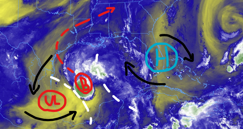
The upper-level low to the west and the ridge to the east are going to limit the volume the system can grow into, but they will not impact the strength.
In fact, given the direction Beryl is moving and the mid-level and upper-level flow ahead of it, we may see some beneficial venting and pre-conditioning of the atmosphere ahead of Beryl which would allow it to grow – quickly – in strength as it approaches the coast of Texas.
But the area that would be impacted by the strongest part of Beryl would still be small, since the volume of space is limited.
REGIONAL DAY TO DAY FORECAST
Today: Partly sunny. A chance of showers and thunderstorms this morning, then showers and thunderstorms likely this afternoon. Highs in the lower 90s. North winds around 5 mph, becoming west this afternoon. Chance of rain 70 percent. Heat index values up to 108.
Tonight: Mostly cloudy with a chance of showers and thunderstorms in the evening, then partly cloudy after midnight. Humid with lows in the mid 70s. Southwest winds around 5 mph. Chance of rain 40 percent.
Sunday: Mostly sunny. A slight chance of showers and thunderstorms in the morning, then showers and thunderstorms likely in the afternoon. Humid with highs in the lower 90s. Southwest winds around 5 mph. Chance of rain 50 percent. Heat index values up to 108.
Sunday Night: Mostly cloudy. A slight chance of showers and thunderstorms in the evening. Humid with lows in the mid 70s. South winds around 5 mph. Chance of rain 20 percent. Heat index values up to 105 early in the evening.
Monday: Mostly sunny. A slight chance of showers and thunderstorms in the morning, then showers and thunderstorms likely in the afternoon. Humid with highs in the mid 90s. Southeast winds around 5 mph. Chance of rain 40 percent. Heat index values up to 109.
Monday Night: Mostly cloudy. A chance of showers and thunderstorms, mainly in the evening. Lows in the mid 70s. Chance of rain 20 percent.
Tuesday: Showers and thunderstorms. Highs around 90. Chance of rain 60 percent. Heat index values up to 110.
Tuesday Night: Mostly cloudy. A chance of showers and thunderstorms, mainly in the evening. Lows in the mid 70s. Chance of rain 20 percent.
Wednesday: Mostly sunny. A chance of showers and thunderstorms in the morning, then showers and thunderstorms likely in the afternoon. Highs in the lower 90s. Chance of rain 40 percent. Heat index values up to 105.
Wednesday Night: Partly cloudy with a slight chance of showers and thunderstorms. Lows in the mid 70s. Chance of rain 20 percent.
Thursday: Mostly sunny with a chance of showers and thunderstorms. Highs in the mid 90s. Chance of rain 30 percent. Heat index values up to 110.
Thursday Night: Partly cloudy. A slight chance of showers and thunderstorms in the evening. Lows in the mid 70s. Chance of rain 20 percent. Heat index values up to 105 early in the evening.
Friday: Mostly sunny. A slight chance of showers and thunderstorms in the morning, then a chance of showers and thunderstorms in the afternoon. Highs in the mid 90s. Chance of rain 30 percent. Heat index values up to 105.


