Depending on who you are and what your threshold for weather-related interruption is I know it can feel exciting – or scary – to hear about the chance for snow and colder temperatures.
For what it is worth, despite the handful of messages like the one in the title, I have been discussing the shot for snow. I think this is my second post on the site and fifth mention of it publicly across videos, social media posts, and site/app updates.
The reason I’m not consuming your time with it in a barrage of posts? We simply can’t know how impactful any of the potential outcomes will eventually be, yet. So I’m not going to waste your time with monitoring every next model run when none of the models are going to be all that accurate with specifics at this distance in time.
Because at each next step of a weather forecast there are always more potential outcomes. So the further down the line you go, you eventually get to nearly infinite potential outcomes. Like this diagram (very poorly drawn, by a not-artistic meteorologist). If we start at the first circle, we have three potential outcomes at the first step. But by step three we have 27 outcomes! now lets go into the future 100 steps – that’s a big number!

These weather models work similarly, in a sense. They can produce some pretty wild outcomes farther out in time because they are following a path of potentials. One wrong step and they can end up in the Land of Make Believe really quickly.
LOOKING AT THE DATA
That said, we can look at the overall setup to see just what the models look like today and why there is such a buzz.
First I want to highlight that there is a good shot it will be colder than normal. I’ve shown this chart I made a few times on facebook and I want to take a second to highlight how to read it.

The ensemble models look at a ton of potential outcomes at once and then take an average of what happens across all of the outcomes. For example, of the 80 outcomes at for each day, what you see above is the percentage – on each day – of a particular outcome for the region: will is be warmer than normal, normal or colder than normal. And then the warmer and colder are broken down into three categories on magnitude.
Notice the chart shows, nearly unanimously, that we will be below normal from Jan 7th through the 11th.
And about 20-percent to 40-percent show “strong below.” And the “strong below” category is where we need to be for us to even start to talk about any type of wintry weather. But at only 20-percent to 40-percent, that isn’t even a majority. So we have some room for uncertainty on specifics, but the threat for colder than normal is pretty much a lock.
As for the snow, that gets even more complicated.
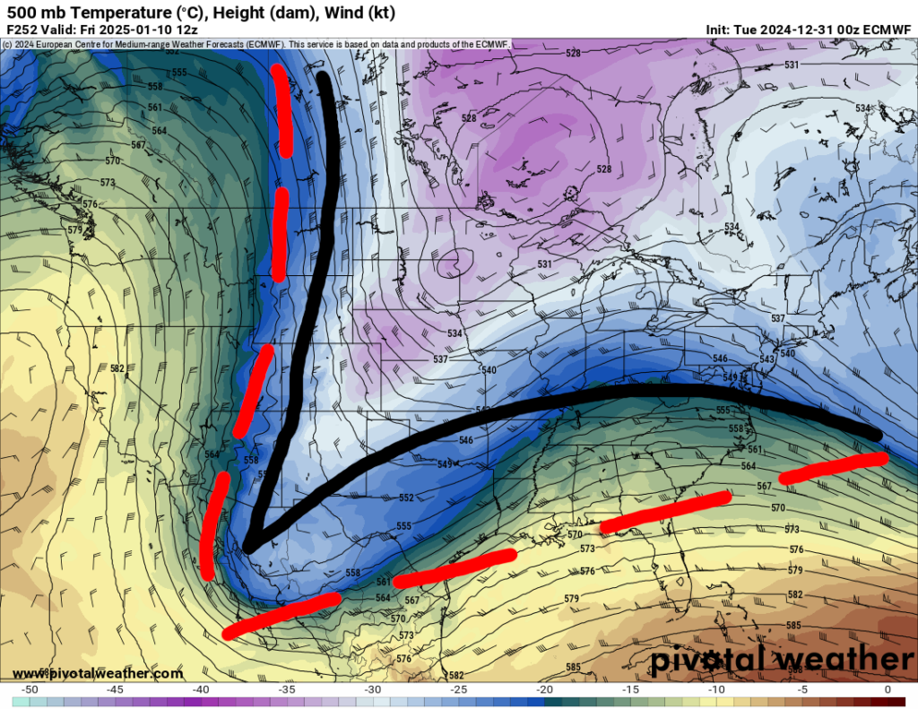
Up at 500mb, the anomaly maps show a cutoff low near the Baja and into southern Arizona. That is the blue blob you see down there on the maps below. This is a good start for impactful weather for our area. Not snow, but impactful weather. Some days we get severe weather from this type of setup, other times we can get snow.


Both maps, the ECMWF and the GFS computer weather models agree on something happening down there. They also agree that the 500mb heights ahead of that cutoff low (the lines on the map which show points of equal pressure) bowing northward ahead of it and then flattening out or even sagging southward.
Recall back to what we have learned over the years about producing snow for the Gulf Coast. And recall my hypothesis about “the elbow” at 500mb which helps deliver both cold area ahead of the chance for precipitation, and then the precipitation.
Int he map below, the ECMWF computer weather model, I have annotated the general “elbow” on the map in black and then the “desired” elbow for snow in dashed red. If you want more snow, the black line needs to be below and behind the red line. It is neither.

That doesn’t mean we are guaranteed no snow. It just means that the models, today, do not show an upper-level patter favorable for snow. And these models have been waffling back and forth for the last few days. Every 6 hours we get a new one. and every six hours it is different. A bit like I explained toward the start of this post.
That is why social media is filled with “SOUTHERN BLIZZARD!!!” and “OMG COLD!!” and “POSSIBLE LIFE_THREATENING BLIZZOCANEMAGGEDDON OF DOOOMMMM!!!” posts. Because every six hours we get a new model and every six hours that model is a new different outcome.
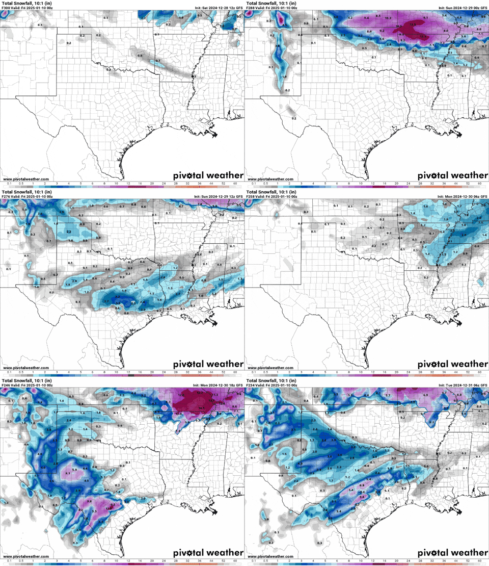
For instance, look at the last handful of runs during the last three days and the wildly different outcomes.

And none of these are correct.
None.
They may be on the right track or – as a collection – pointing toward a potential general outcome. But none is “right” for the correct reasons by any measurably metric. If we do end up with something as shown in a model from the last few days it is more about a “blind squirrel finding a nut” than anything else.
WHEN WILL WE KNOW?
No time soon, sadly. When it comes to forecasting wintry weather across the Gulf Coast, I have made a fn little diagram to ID if you will get snow, sleet, a wintry mix, freezing rain, or just regular rain. And today I went in and annotated on it as to when we start to get a good idea about each step.
And none is really sooner than 72 hours out.

So for all the hoopla on social media about snow and blizzards around January 9th, we can’t start to get a reasonable idea about the outcome until January 6th or 7th.
Stinks, I know. But forecasting wintry weather next the Gulf is very difficult.
And as for the cold, when you see maps like this:

Please know that this map shows lows around 25F to 30F and highs 35F to 40F for our area. Cold, but nothing too crazy. It lines up with a “normal” shot of cold for us for this time of year.
THE BOTTOM LINE
The forecast is showing a chance for cold weather. The cold weather may last up to five days. Some model guidance is showing a chance for some wintry precipitation, but I don’t think there is any reason to get excited (or scared) at this point.
Could it get even colder? Absolutely.
Could it be less cold? Absolutely.
Could it flip and we are actually warmer than normal? Probably not.
Could it snow? Sure.
Could it not snow? Sure.
Could there be severe weather ahead of the cold? Definitely.
Could there be an ice storm? Sure.
Could it all just be cold rain? Totally.
Could it be like December 2017 again? Probably not. That was a once-in-a-100-year event.
What is it going to do at your house at a specific date and time during all of this? No idea.
The NQLBOT forecast I think is actually pretty good today. Maybe slightly too warm on the 7th and 8th, but its a computer, so it is doing the best it can.

But notice it shows no snow. And highs above freezing every day.


I don’t do pay pal or any of that stuff BUT I would send you some pizza money if I knew how. Send me your mailing address
A neat term for the phenomenon you illustrate in that red tree is “combinatorial explosion”. A lot of math and computer science research is dedicated to finding ways around it.