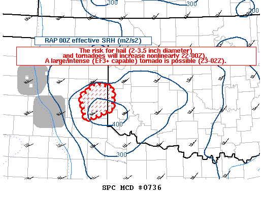
Interesting wording from the SPC. At the time of this Discussion a tornado was on the ground in this outlined area.
Mesoscale Discussion 0736
NWS Storm Prediction Center Norman OK
0456 PM CDT Tue May 16 2017Areas affected…east-central TX Panhandle
Concerning…Tornado Watch 220…
Valid 162156Z – 162300Z
The severe weather threat for Tornado Watch 220 continues.
SUMMARY…The risk for very large to giant hail (2-3.5 inches in
diameter) and tornadoes will increase nonlinearly (22-00Z). A
large/intense (EF3+ capable) tornado is possible (23-02Z) given the
strengthening low-level shear, very large buoyancy, and the mature
phase of a quasi-discrete supercell.DISCUSSION…Radar imagery shows a north-south cluster of supercells
over the eastern TX Panhandle which have moved east of the dryline.
OK and West TX mesonet observations show dewpoints in the 66-69
degrees F range and temperatures in the middle 70s to around 80.
Very strong backing of low-level flow, perhaps partially induced by
parent storms to the west, has enlarged the low-level hodograph size
during the past 30 minutes from Childress County to Wheeler County
with 2-4 mb/hour falls in the past 2 hours. RAP forecast soundings
show 0-1 km SRH increasing from 150 m2/s2 to 350 m2/s2 (locally
higher and augmented by storms) during the 22-00Z period. As the
low-level shear continues to increase over the next couple of hours,
expect with medium to higher confidence of a large/intense tornado
—potentially capable of EF3+ intensity— evolving from supercell
cluster in Wheeler/Gray/Collingsworth counties...Smith/Guyer.. 05/16/2017
…Please see www.spc.noaa.gov for graphic product…
ATTN…WFO…OUN…LUB…AMA…
LAT…LON 35220072 35510031 35429986 34969988 34710057 35220072


