The Storm Prediction Center has upgraded part of the area to a High Risk for severe weather. That is a “5” on the 1-to-5 scale where a “5” is the highest risk for the most significant severe weather. The main concern from the SPC is, and this is a quote, “Significant tornado potential, along with very large hail and destructive damaging wind gusts” across the region that does include our area.
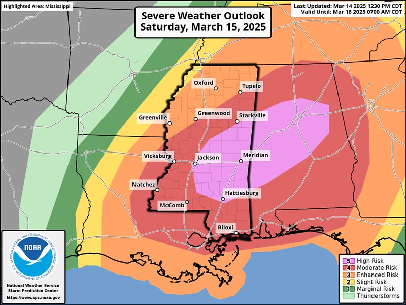
The upgrade to a “High” from the “Moderate” yesterday has to do with mostly with spatial distribution and the specificity the high-res models can provide. The risk for the severity of the storms did not increase. Instead, a bit like I explained yesterday briefly, the evidence supports being able to delineate between the risk in one place versus another.
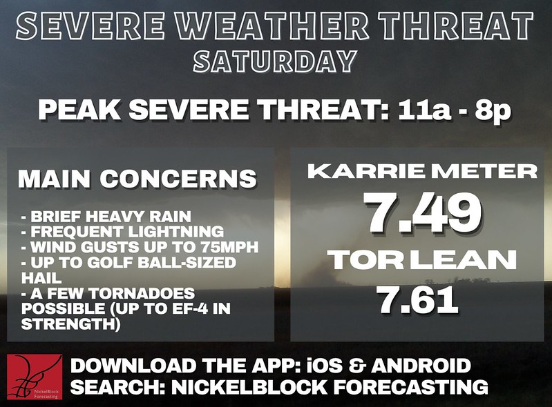
The Karrie Meter has moved a bit. We gained back the 6s and 7s on the NAM model as shown on the maps below.


The averaged values across a wider spread of the higher resolution model guidance and the values are up about 0.75. And the “Tornado lean” value is basically unchanged. That is to say that while the actual value has gotten higher the risk of tornadoes did not increase in the same relative way.
THE GENERAL TIMELINE & THREATS
Briefly here (because I broke the timeline down by county, too), I want to let folks know that we may see three distinct periods of potential storms and the opportunity for severe weather. Once tonight, once in the (mostly) pre-dawn hours tomorrow, and then a third chance in the afternoon and evening tomorrow.
By the time it is all said at done…
EVERYONE – Brief heavy rain, lightning, and wind gusts up to 40mph
MOST PEOPLE – Brief heavy rain, lightning and wind gusts up to 45mph
MANY AREAS – A few rounds of heavy rain, lightning, wind gusts up to 50mph and small hail
SOME FOLKS – Multiple rounds of heavy rain, frequent lightning, wind gusts up to 60mph and small hail
A FEW LOCATIONS – Multiple rounds of heavy rain, frequent lightning, wind gusts up to 65mph, and large hail
SELECT SPOTS – Multiple rounds of heavy rain, localized flash flooding, frequent lightning, win gusts up to 75mph, large hail and a tornado (up to EF4 in strength)
So please take the time to read through this breakdown and understand your risks and when those risks may arrive.
During previous events, some folks have asked if there is a way to ‘help’ or ‘say thanks’ for all of the forecasting work I do. For the longest time I said, ‘Nah! I do this to be helpful!’
I was convinced by folks, though, that others want to ‘help’ like I do – just differently.
And their way of helping, or simply saying ‘thank you’ is with a donation to the blog to help keep it running – or to help keep me running.
So I’ve added this link. If you are one of those people, let me say thank you to YOU.
I-20 Corridor
Hinds County
We have multiple rounds of storms with some severe weather possible at each pass.
Everyone should expect:
✅ Brief heavy rain
✅ Frequent lightning
✅ Wind gusts up to 40 mph
🔴 Many areas will see, at least, small hail and wind to 60mph
🔴 Some areas may wind up to 75mph
🔴 A few areas could also see a tornado
PART 1
7p – 11p tonight: A few isolated storms are possible. Strong storms are likely, a few may be severe. Main threats include brief heavy rain, frequent lightning, wind gusts up to 60mph, and hail up to the size of golf balls. A tornado can’t be ruled out, either. Strong tornadoes are possible, up to EF3 in strength.
PART 2
4a – 8a tomorrow: Scattered showers and rumbles of thunder are likely. Strong storms are possible, a few severe storms can’t be ruled out. Main threats include brief heavy rain, frequent lightning, wind gusts up to 60mph, and hail up to the size of baseballs. A tornado can’t be ruled out, either.
PART 3
9a – 11a tomorrow: Storms just starting, scattered showers and rumbles of thunder possible. Severe weather threat should remain low at this point.
11a – 3p tomorrow: Scattered storms likely. Most storms will be rotating and organized, many may be severe. Main threats include heavy rain, frequent lightning, wind gusts up to 75mph, and hail up to the size of golf balls. Tornadoes are possible, up to EF4 in strength.
3p – 7p tomorrow: Storms ending. Strong storms are possible, a few severe storms can’t be ruled out. Main threats include brief heavy rain, frequent lightning, wind gusts up to 60mph, and hail up to the size of baseballs. A tornado can’t be ruled out, either.
IMPACTS
🟡 A Tornado Watch from the NWS is likely
🟡 Storm-related warnings from the NWS are likely
⚠️ Brief, localized flash flooding possible
🌳 Downed trees likely
🚧 Roads may become impassable for a short time
⚡ Power outages possible (lasting up to 12 hours)
🏠 Structural damage possible from hail, wind, tornadoes
📵 Wireless communication disruptions possible
DURING THE DAY
📱 Make sure you have the NickelBlock Forecasting app downloaded
📻 Keep a NOAA Weather Radio nearby
📺 Stay tuned to local media (for live coverage and emergency information as conditions evolve)
✅ Have multiple ways to receive warnings
Copiah County
We have multiple rounds of storms with some severe weather possible at each pass.
Everyone should expect:
✅ Brief heavy rain
✅ Frequent lightning
✅ Wind gusts up to 40 mph
🔴 Many areas will see, at least, small hail and wind to 60mph
🔴 Some areas may wind up to 75mph
🔴 A few areas could also see a tornado
PART 1
7p – 11p tonight: A few isolated storms are possible. Strong storms are likely, a few may be severe. Main threats include brief heavy rain, frequent lightning, wind gusts up to 60mph, and hail up to the size of golf balls. A tornado can’t be ruled out, either. Strong tornadoes are possible, up to EF3 in strength.
PART 2
4a – 8a tomorrow: Scattered showers and rumbles of thunder are likely. Strong storms are possible, a few severe storms can’t be ruled out. Main threats include brief heavy rain, frequent lightning, wind gusts up to 60mph, and hail up to the size of baseballs. A tornado can’t be ruled out, either.
PART 3
9a – 11a tomorrow: Storms just starting, scattered showers and rumbles of thunder possible. Severe weather threat should remain low at this point.
11a – 3p tomorrow: Scattered storms likely. Most storms will be rotating and organized, many may be severe. Main threats include heavy rain, frequent lightning, wind gusts up to 75mph, and hail up to the size of golf balls. Tornadoes are possible, up to EF4 in strength.
3p – 7p tomorrow: Storms ending. Strong storms are possible, a few severe storms can’t be ruled out. Main threats include brief heavy rain, frequent lightning, wind gusts up to 60mph, and hail up to the size of baseballs. A tornado can’t be ruled out, either.
IMPACTS
🟡 A Tornado Watch from the NWS is likely
🟡 Storm-related warnings from the NWS are likely
⚠️ Brief, localized flash flooding possible
🌳 Downed trees likely
🚧 Roads may become impassable for a short time
⚡ Power outages possible (lasting up to 12 hours)
🏠 Structural damage possible from hail, wind, tornadoes
📵 Wireless communication disruptions possible
DURING THE DAY
📱 Make sure you have the NickelBlock Forecasting app downloaded
📻 Keep a NOAA Weather Radio nearby
📺 Stay tuned to local media (for live coverage and emergency information as conditions evolve)
✅ Have multiple ways to receive warnings
Rankin County
We have multiple rounds of storms with some severe weather possible at each pass.
Everyone should expect:
✅ Brief heavy rain
✅ Frequent lightning
✅ Wind gusts up to 40 mph
🔴 Many areas will see, at least, small hail and wind to 60mph
🔴 Some areas may wind up to 75mph
🔴 A few areas could also see a tornado
PART 1
7p – 11p tonight: A few isolated storms are possible. Strong storms are likely, a few may be severe. Main threats include brief heavy rain, frequent lightning, wind gusts up to 60mph, and hail up to the size of golf balls. A tornado can’t be ruled out, either. Strong tornadoes are possible, up to EF3 in strength.
PART 2
4a – 8a tomorrow: Scattered showers and rumbles of thunder are likely. Strong storms are possible, a few severe storms can’t be ruled out. Main threats include brief heavy rain, frequent lightning, wind gusts up to 60mph, and hail up to the size of baseballs. A tornado can’t be ruled out, either.
PART 3
9a – 11a tomorrow: Storms just starting, scattered showers and rumbles of thunder possible. Severe weather threat should remain low at this point.
11a – 3p tomorrow: Scattered storms likely. Most storms will be rotating and organized, many may be severe. Main threats include heavy rain, frequent lightning, wind gusts up to 75mph, and hail up to the size of golf balls. Tornadoes are possible, up to EF4 in strength.
3p – 7p tomorrow: Storms ending. Strong storms are possible, a few severe storms can’t be ruled out. Main threats include brief heavy rain, frequent lightning, wind gusts up to 60mph, and hail up to the size of baseballs. A tornado can’t be ruled out, either.
IMPACTS
🟡 A Tornado Watch from the NWS is likely
🟡 Storm-related warnings from the NWS are likely
⚠️ Brief, localized flash flooding possible
🌳 Downed trees likely
🚧 Roads may become impassable for a short time
⚡ Power outages possible (lasting up to 12 hours)
🏠 Structural damage possible from hail, wind, tornadoes
📵 Wireless communication disruptions possible
DURING THE DAY
📱 Make sure you have the NickelBlock Forecasting app downloaded
📻 Keep a NOAA Weather Radio nearby
📺 Stay tuned to local media (for live coverage and emergency information as conditions evolve)
✅ Have multiple ways to receive warnings
Simpson County
We have multiple rounds of storms with some severe weather possible at each pass.
Everyone should expect:
✅ Brief heavy rain
✅ Frequent lightning
✅ Wind gusts up to 40 mph
🔴 Many areas will see, at least, small hail and wind to 60mph
🔴 Some areas may wind up to 75mph
🔴 A few areas could also see a tornado
PART 1
7p – 11p tonight: A few isolated storms are possible. Strong storms are likely, a few may be severe. Main threats include brief heavy rain, frequent lightning, wind gusts up to 60mph, and hail up to the size of golf balls. A tornado can’t be ruled out, either. Strong tornadoes are possible, up to EF3 in strength.
PART 2
4a – 8a tomorrow: Scattered showers and rumbles of thunder are likely. Strong storms are possible, a few severe storms can’t be ruled out. Main threats include brief heavy rain, frequent lightning, wind gusts up to 60mph, and hail up to the size of baseballs. A tornado can’t be ruled out, either.
PART 3
9a – 11a tomorrow: Storms just starting, scattered showers and rumbles of thunder possible. Severe weather threat should remain low at this point.
11a – 3p tomorrow: Scattered storms likely. Most storms will be rotating and organized, many may be severe. Main threats include heavy rain, frequent lightning, wind gusts up to 75mph, and hail up to the size of golf balls. Tornadoes are possible, up to EF4 in strength.
3p – 7p tomorrow: Storms ending. Strong storms are possible, a few severe storms can’t be ruled out. Main threats include brief heavy rain, frequent lightning, wind gusts up to 60mph, and hail up to the size of baseballs. A tornado can’t be ruled out, either.
IMPACTS
🟡 A Tornado Watch from the NWS is likely
🟡 Storm-related warnings from the NWS are likely
⚠️ Brief, localized flash flooding possible
🌳 Downed trees likely
🚧 Roads may become impassable for a short time
⚡ Power outages possible (lasting up to 12 hours)
🏠 Structural damage possible from hail, wind, tornadoes
📵 Wireless communication disruptions possible
DURING THE DAY
📱 Make sure you have the NickelBlock Forecasting app downloaded
📻 Keep a NOAA Weather Radio nearby
📺 Stay tuned to local media (for live coverage and emergency information as conditions evolve)
✅ Have multiple ways to receive warnings
Scott County
We have multiple rounds of storms with some severe weather possible at each pass.
Everyone should expect:
✅ Brief heavy rain
✅ Frequent lightning
✅ Wind gusts up to 40 mph
🔴 Many areas will see, at least, small hail and wind to 60mph
🔴 Some areas may wind up to 75mph
🔴 A few areas could also see a tornado
PART 1
8p – 12a tonight: A few isolated storms are possible. Strong storms are likely, a few may be severe. Main threats include brief heavy rain, frequent lightning, wind gusts up to 60mph, and hail up to the size of golf balls. A tornado can’t be ruled out, either. Strong tornadoes are possible, up to EF3 in strength.
PART 2
4a – 8a tomorrow: Scattered showers and rumbles of thunder are likely. Strong storms are possible, a few severe storms can’t be ruled out. Main threats include brief heavy rain, frequent lightning, wind gusts up to 60mph, and hail up to the size of baseballs. A tornado can’t be ruled out, either.
PART 3
10a – 12p tomorrow: Storms just starting, scattered showers and rumbles of thunder possible. Severe weather threat should remain low at this point.
12p – 4p tomorrow: Scattered storms likely. Most storms will be rotating and organized, many may be severe. Main threats include heavy rain, frequent lightning, wind gusts up to 75mph, and hail up to the size of golf balls. Tornadoes are possible, up to EF4 in strength.
4p – 8p tomorrow: Storms ending. Strong storms are possible, a few severe storms can’t be ruled out. Main threats include brief heavy rain, frequent lightning, wind gusts up to 60mph, and hail up to the size of baseballs. A tornado can’t be ruled out, either.
IMPACTS
🟡 A Tornado Watch from the NWS is likely
🟡 Storm-related warnings from the NWS are likely
⚠️ Brief, localized flash flooding possible
🌳 Downed trees likely
🚧 Roads may become impassable for a short time
⚡ Power outages possible (lasting up to 12 hours)
🏠 Structural damage possible from hail, wind, tornadoes
📵 Wireless communication disruptions possible
DURING THE DAY
📱 Make sure you have the NickelBlock Forecasting app downloaded
📻 Keep a NOAA Weather Radio nearby
📺 Stay tuned to local media (for live coverage and emergency information as conditions evolve)
✅ Have multiple ways to receive warnings
Smith County
We have multiple rounds of storms with some severe weather possible at each pass.
Everyone should expect:
✅ Brief heavy rain
✅ Frequent lightning
✅ Wind gusts up to 40 mph
🔴 Many areas will see, at least, small hail and wind to 60mph
🔴 Some areas may wind up to 75mph
🔴 A few areas could also see a tornado
PART 1
8p – 12a tonight: A few isolated storms are possible. Strong storms are likely, a few may be severe. Main threats include brief heavy rain, frequent lightning, wind gusts up to 60mph, and hail up to the size of golf balls. A tornado can’t be ruled out, either. Strong tornadoes are possible, up to EF3 in strength.
PART 2
4a – 8a tomorrow: Scattered showers and rumbles of thunder are likely. Strong storms are possible, a few severe storms can’t be ruled out. Main threats include brief heavy rain, frequent lightning, wind gusts up to 60mph, and hail up to the size of baseballs. A tornado can’t be ruled out, either.
PART 3
10a – 12p tomorrow: Storms just starting, scattered showers and rumbles of thunder possible. Severe weather threat should remain low at this point.
12p – 4p tomorrow: Scattered storms likely. Most storms will be rotating and organized, many may be severe. Main threats include heavy rain, frequent lightning, wind gusts up to 75mph, and hail up to the size of golf balls. Tornadoes are possible, up to EF4 in strength.
4p – 8p tomorrow: Storms ending. Strong storms are possible, a few severe storms can’t be ruled out. Main threats include brief heavy rain, frequent lightning, wind gusts up to 60mph, and hail up to the size of baseballs. A tornado can’t be ruled out, either.
IMPACTS
🟡 A Tornado Watch from the NWS is likely
🟡 Storm-related warnings from the NWS are likely
⚠️ Brief, localized flash flooding possible
🌳 Downed trees likely
🚧 Roads may become impassable for a short time
⚡ Power outages possible (lasting up to 12 hours)
🏠 Structural damage possible from hail, wind, tornadoes
📵 Wireless communication disruptions possible
DURING THE DAY
📱 Make sure you have the NickelBlock Forecasting app downloaded
📻 Keep a NOAA Weather Radio nearby
📺 Stay tuned to local media (for live coverage and emergency information as conditions evolve)
✅ Have multiple ways to receive warnings
Newton County
We have multiple rounds of storms with some severe weather possible at each pass.
Everyone should expect:
✅ Brief heavy rain
✅ Frequent lightning
✅ Wind gusts up to 40 mph
🔴 Many areas will see, at least, small hail and wind to 60mph
🔴 Some areas may wind up to 75mph
🔴 A few areas could also see a tornado
PART 1
9p – 1a tonight: A few isolated storms are possible. Strong storms are likely, a few may be severe. Main threats include brief heavy rain, frequent lightning, wind gusts up to 60mph, and hail up to the size of golf balls. A tornado can’t be ruled out, either. Strong tornadoes are possible, up to EF3 in strength.
PART 2
4a – 8a tomorrow: Scattered showers and rumbles of thunder are likely. Strong storms are possible, a few severe storms can’t be ruled out. Main threats include brief heavy rain, frequent lightning, wind gusts up to 60mph, and hail up to the size of baseballs. A tornado can’t be ruled out, either.
PART 3
11a – 1p tomorrow: Storms just starting, scattered showers and rumbles of thunder possible. Severe weather threat should remain low at this point.
1p – 5p tomorrow: Scattered storms likely. Most storms will be rotating and organized, many may be severe. Main threats include heavy rain, frequent lightning, wind gusts up to 75mph, and hail up to the size of golf balls. Tornadoes are possible, up to EF4 in strength.
5p – 9p tomorrow: Storms ending. Strong storms are possible, a few severe storms can’t be ruled out. Main threats include brief heavy rain, frequent lightning, wind gusts up to 60mph, and hail up to the size of baseballs. A tornado can’t be ruled out, either.
IMPACTS
🟡 A Tornado Watch from the NWS is likely
🟡 Storm-related warnings from the NWS are likely
⚠️ Brief, localized flash flooding possible
🌳 Downed trees likely
🚧 Roads may become impassable for a short time
⚡ Power outages possible (lasting up to 12 hours)
🏠 Structural damage possible from hail, wind, tornadoes
📵 Wireless communication disruptions possible
DURING THE DAY
📱 Make sure you have the NickelBlock Forecasting app downloaded
📻 Keep a NOAA Weather Radio nearby
📺 Stay tuned to local media (for live coverage and emergency information as conditions evolve)
✅ Have multiple ways to receive warnings
Jasper County
We have multiple rounds of storms with some severe weather possible at each pass.
Everyone should expect:
✅ Brief heavy rain
✅ Frequent lightning
✅ Wind gusts up to 40 mph
🔴 Many areas will see, at least, small hail and wind to 60mph
🔴 Some areas may wind up to 75mph
🔴 A few areas could also see a tornado
PART 1
8p – 12a tonight: A few isolated storms are possible. Strong storms are likely, a few may be severe. Main threats include brief heavy rain, frequent lightning, wind gusts up to 60mph, and hail up to the size of golf balls. A tornado can’t be ruled out, either. Strong tornadoes are possible, up to EF3 in strength.
PART 2
4a – 8a tomorrow: Scattered showers and rumbles of thunder are likely. Strong storms are possible, a few severe storms can’t be ruled out. Main threats include brief heavy rain, frequent lightning, wind gusts up to 60mph, and hail up to the size of baseballs. A tornado can’t be ruled out, either.
PART 3
11a – 1p tomorrow: Storms just starting, scattered showers and rumbles of thunder possible. Severe weather threat should remain low at this point.
1p – 5p tomorrow: Scattered storms likely. Most storms will be rotating and organized, many may be severe. Main threats include heavy rain, frequent lightning, wind gusts up to 75mph, and hail up to the size of golf balls. Tornadoes are possible, up to EF4 in strength.
5p – 9p tomorrow: Storms ending. Strong storms are possible, a few severe storms can’t be ruled out. Main threats include brief heavy rain, frequent lightning, wind gusts up to 60mph, and hail up to the size of baseballs. A tornado can’t be ruled out, either.
IMPACTS
🟡 A Tornado Watch from the NWS is likely
🟡 Storm-related warnings from the NWS are likely
⚠️ Brief, localized flash flooding possible
🌳 Downed trees likely
🚧 Roads may become impassable for a short time
⚡ Power outages possible (lasting up to 12 hours)
🏠 Structural damage possible from hail, wind, tornadoes
📵 Wireless communication disruptions possible
DURING THE DAY
📱 Make sure you have the NickelBlock Forecasting app downloaded
📻 Keep a NOAA Weather Radio nearby
📺 Stay tuned to local media (for live coverage and emergency information as conditions evolve)
✅ Have multiple ways to receive warnings
Lauderdale County
We have multiple rounds of storms with some severe weather possible at each pass.
Everyone should expect:
✅ Brief heavy rain
✅ Frequent lightning
✅ Wind gusts up to 40 mph
🔴 Many areas will see, at least, small hail and wind to 60mph
🔴 Some areas may wind up to 75mph
🔴 A few areas could also see a tornado
PART 1
8p – 12a tonight: A few isolated storms are possible. Strong storms are likely, a few may be severe. Main threats include brief heavy rain, frequent lightning, wind gusts up to 60mph, and hail up to the size of golf balls. A tornado can’t be ruled out, either. Strong tornadoes are possible, up to EF3 in strength.
PART 2
4a – 8a tomorrow: Isolated showers and rumbles os thunder possible. Severe threat low.
PART 3
12p – 2p tomorrow: Storms just starting, scattered showers and rumbles of thunder possible. Severe weather threat should remain low at this point.
2p – 6p tomorrow: Scattered storms likely. Most storms will be rotating and organized, many may be severe. Main threats include heavy rain, frequent lightning, wind gusts up to 75mph, and hail up to the size of golf balls. Tornadoes are possible, up to EF4 in strength.
6p – 10p tomorrow: Storms ending. Strong storms are possible, a few severe storms can’t be ruled out. Main threats include brief heavy rain, frequent lightning, wind gusts up to 60mph, and hail up to the size of baseballs. A tornado can’t be ruled out, either.
IMPACTS
🟡 A Tornado Watch from the NWS is likely
🟡 Storm-related warnings from the NWS are likely
⚠️ Brief, localized flash flooding possible
🌳 Downed trees likely
🚧 Roads may become impassable for a short time
⚡ Power outages possible (lasting up to 12 hours)
🏠 Structural damage possible from hail, wind, tornadoes
📵 Wireless communication disruptions possible
DURING THE DAY
📱 Make sure you have the NickelBlock Forecasting app downloaded
📻 Keep a NOAA Weather Radio nearby
📺 Stay tuned to local media (for live coverage and emergency information as conditions evolve)
✅ Have multiple ways to receive warnings
Clarke County
We have multiple rounds of storms with some severe weather possible at each pass.
Everyone should expect:
✅ Brief heavy rain
✅ Frequent lightning
✅ Wind gusts up to 40 mph
🔴 Many areas will see, at least, small hail and wind to 60mph
🔴 Some areas may wind up to 75mph
🔴 A few areas could also see a tornado
PART 1
8p – 12a tonight: A few isolated storms are possible. Strong storms are likely, a few may be severe. Main threats include brief heavy rain, frequent lightning, wind gusts up to 60mph, and hail up to the size of golf balls. A tornado can’t be ruled out, either. Strong tornadoes are possible, up to EF3 in strength.
PART 2
4a – 8a tomorrow: Isolated showers and rumbles os thunder possible. Severe threat low.
PART 3
12p – 2p tomorrow: Storms just starting, scattered showers and rumbles of thunder possible. Severe weather threat should remain low at this point.
2p – 6p tomorrow: Scattered storms likely. Most storms will be rotating and organized, many may be severe. Main threats include heavy rain, frequent lightning, wind gusts up to 75mph, and hail up to the size of golf balls. Tornadoes are possible, up to EF4 in strength.
6p – 10p tomorrow: Storms ending. Strong storms are possible, a few severe storms can’t be ruled out. Main threats include brief heavy rain, frequent lightning, wind gusts up to 60mph, and hail up to the size of baseballs. A tornado can’t be ruled out, either.
IMPACTS
🟡 A Tornado Watch from the NWS is likely
🟡 Storm-related warnings from the NWS are likely
⚠️ Brief, localized flash flooding possible
🌳 Downed trees likely
🚧 Roads may become impassable for a short time
⚡ Power outages possible (lasting up to 12 hours)
🏠 Structural damage possible from hail, wind, tornadoes
📵 Wireless communication disruptions possible
DURING THE DAY
📱 Make sure you have the NickelBlock Forecasting app downloaded
📻 Keep a NOAA Weather Radio nearby
📺 Stay tuned to local media (for live coverage and emergency information as conditions evolve)
✅ Have multiple ways to receive warnings
HWY 84 Corridor
Lincoln County
We have multiple rounds of storms with some severe weather possible at each pass.
Everyone should expect:
✅ Brief heavy rain
✅ Frequent lightning
✅ Wind gusts up to 40 mph
🔴 Many areas will see, at least, small hail and wind to 60mph
🔴 Some areas may wind up to 75mph
🔴 A few areas could also see a tornado
PART 1
7p – 11p tonight: A few isolated storms are possible. Strong storms are likely, a few may be severe. Main threats include brief heavy rain, frequent lightning, wind gusts up to 60mph, and hail up to the size of golf balls. A tornado can’t be ruled out, either. Strong tornadoes are possible, up to EF3 in strength.
PART 2
4a – 8a tomorrow: Scattered showers and rumbles of thunder are likely. Strong storms are possible, a few severe storms can’t be ruled out. Main threats include brief heavy rain, frequent lightning, wind gusts up to 60mph, and hail up to the size of baseballs. A tornado can’t be ruled out, either.
PART 3
9a – 11a tomorrow: Storms just starting, scattered showers and rumbles of thunder possible. Severe weather threat should remain low at this point.
11a – 3p tomorrow: Scattered storms likely. Most storms will be rotating and organized, many may be severe. Main threats include heavy rain, frequent lightning, wind gusts up to 75mph, and hail up to the size of golf balls. Tornadoes are possible, up to EF4 in strength.
3p – 7p tomorrow: Storms ending. Strong storms are possible, a few severe storms can’t be ruled out. Main threats include brief heavy rain, frequent lightning, wind gusts up to 60mph, and hail up to the size of baseballs. A tornado can’t be ruled out, either.
IMPACTS
🟡 A Tornado Watch from the NWS is likely
🟡 Storm-related warnings from the NWS are likely
⚠️ Brief, localized flash flooding possible
🌳 Downed trees likely
🚧 Roads may become impassable for a short time
⚡ Power outages possible (lasting up to 12 hours)
🏠 Structural damage possible from hail, wind, tornadoes
📵 Wireless communication disruptions possible
DURING THE DAY
📱 Make sure you have the NickelBlock Forecasting app downloaded
📻 Keep a NOAA Weather Radio nearby
📺 Stay tuned to local media (for live coverage and emergency information as conditions evolve)
✅ Have multiple ways to receive warnings
Lawrence County
We have multiple rounds of storms with some severe weather possible at each pass.
Everyone should expect:
✅ Brief heavy rain
✅ Frequent lightning
✅ Wind gusts up to 40 mph
🔴 Many areas will see, at least, small hail and wind to 60mph
🔴 Some areas may wind up to 75mph
🔴 A few areas could also see a tornado
PART 1
7p – 11p tonight: A few isolated storms are possible. Strong storms are likely, a few may be severe. Main threats include brief heavy rain, frequent lightning, wind gusts up to 60mph, and hail up to the size of golf balls. A tornado can’t be ruled out, either. Strong tornadoes are possible, up to EF3 in strength.
PART 2
4a – 8a tomorrow: Scattered showers and rumbles of thunder are likely. Strong storms are possible, a few severe storms can’t be ruled out. Main threats include brief heavy rain, frequent lightning, wind gusts up to 60mph, and hail up to the size of baseballs. A tornado can’t be ruled out, either.
PART 3
9a – 11a tomorrow: Storms just starting, scattered showers and rumbles of thunder possible. Severe weather threat should remain low at this point.
11a – 3p tomorrow: Scattered storms likely. Most storms will be rotating and organized, many may be severe. Main threats include heavy rain, frequent lightning, wind gusts up to 75mph, and hail up to the size of golf balls. Tornadoes are possible, up to EF4 in strength.
3p – 7p tomorrow: Storms ending. Strong storms are possible, a few severe storms can’t be ruled out. Main threats include brief heavy rain, frequent lightning, wind gusts up to 60mph, and hail up to the size of baseballs. A tornado can’t be ruled out, either.
IMPACTS
🟡 A Tornado Watch from the NWS is likely
🟡 Storm-related warnings from the NWS are likely
⚠️ Brief, localized flash flooding possible
🌳 Downed trees likely
🚧 Roads may become impassable for a short time
⚡ Power outages possible (lasting up to 12 hours)
🏠 Structural damage possible from hail, wind, tornadoes
📵 Wireless communication disruptions possible
DURING THE DAY
📱 Make sure you have the NickelBlock Forecasting app downloaded
📻 Keep a NOAA Weather Radio nearby
📺 Stay tuned to local media (for live coverage and emergency information as conditions evolve)
✅ Have multiple ways to receive warnings
Jeff Davis County
We have multiple rounds of storms with some severe weather possible at each pass.
Everyone should expect:
✅ Brief heavy rain
✅ Frequent lightning
✅ Wind gusts up to 40 mph
🔴 Many areas will see, at least, small hail and wind to 60mph
🔴 Some areas may wind up to 75mph
🔴 A few areas could also see a tornado
PART 1
8p – 12a tonight: A few isolated storms are possible. Strong storms are possible. Main threats include brief heavy rain, frequent lightning, wind gusts up to 60mph, and hail up to the size of quarters. A tornado can’t be ruled out, either. Strong tornadoes are possible, up to EF3 in strength.
PART 2
3a – 7a tomorrow: Scattered showers and rumbles of thunder are likely. Strong storms are possible, a few severe storms can’t be ruled out. Main threats include brief heavy rain, frequent lightning, wind gusts up to 60mph, and hail up to the size of golf balls. A tornado can’t be ruled out, either.
PART 3
10a – 12p tomorrow: Storms just starting, scattered showers and rumbles of thunder possible. Severe weather threat should remain low at this point.
12p – 4p tomorrow: Scattered storms likely. Most storms will be rotating and organized, many may be severe. Main threats include heavy rain, frequent lightning, wind gusts up to 75mph, and hail up to the size of golf balls. Tornadoes are possible, up to EF4 in strength.
4p – 8p tomorrow: Storms ending. Strong storms are possible, a few severe storms can’t be ruled out. Main threats include brief heavy rain, frequent lightning, wind gusts up to 60mph, and hail up to the size of baseballs. A tornado can’t be ruled out, either.
IMPACTS
🟡 A Tornado Watch from the NWS is likely
🟡 Storm-related warnings from the NWS are likely
⚠️ Brief, localized flash flooding possible
🌳 Downed trees likely
🚧 Roads may become impassable for a short time
⚡ Power outages possible (lasting up to 12 hours)
🏠 Structural damage possible from hail, wind, tornadoes
📵 Wireless communication disruptions possible
DURING THE DAY
📱 Make sure you have the NickelBlock Forecasting app downloaded
📻 Keep a NOAA Weather Radio nearby
📺 Stay tuned to local media (for live coverage and emergency information as conditions evolve)
✅ Have multiple ways to receive warnings
Covington County
We have multiple rounds of storms with some severe weather possible at each pass.
Everyone should expect:
✅ Brief heavy rain
✅ Frequent lightning
✅ Wind gusts up to 40 mph
🔴 Many areas will see, at least, small hail and wind to 60mph
🔴 Some areas may wind up to 75mph
🔴 A few areas could also see a tornado
PART 1
8p – 12a tonight: A few isolated storms are possible. Strong storms are possible. Main threats include brief heavy rain, frequent lightning, wind gusts up to 60mph, and hail up to the size of quarters. A tornado can’t be ruled out, either. Strong tornadoes are possible, up to EF3 in strength.
PART 2
3a – 7a tomorrow: Scattered showers and rumbles of thunder are likely. Strong storms are possible, a few severe storms can’t be ruled out. Main threats include brief heavy rain, frequent lightning, wind gusts up to 60mph, and hail up to the size of golf balls. A tornado can’t be ruled out, either.
PART 3
10a – 12p tomorrow: Storms just starting, scattered showers and rumbles of thunder possible. Severe weather threat should remain low at this point.
12p – 4p tomorrow: Scattered storms likely. Most storms will be rotating and organized, many may be severe. Main threats include heavy rain, frequent lightning, wind gusts up to 75mph, and hail up to the size of golf balls. Tornadoes are possible, up to EF4 in strength.
4p – 8p tomorrow: Storms ending. Strong storms are possible, a few severe storms can’t be ruled out. Main threats include brief heavy rain, frequent lightning, wind gusts up to 60mph, and hail up to the size of baseballs. A tornado can’t be ruled out, either.
IMPACTS
🟡 A Tornado Watch from the NWS is likely
🟡 Storm-related warnings from the NWS are likely
⚠️ Brief, localized flash flooding possible
🌳 Downed trees likely
🚧 Roads may become impassable for a short time
⚡ Power outages possible (lasting up to 12 hours)
🏠 Structural damage possible from hail, wind, tornadoes
📵 Wireless communication disruptions possible
DURING THE DAY
📱 Make sure you have the NickelBlock Forecasting app downloaded
📻 Keep a NOAA Weather Radio nearby
📺 Stay tuned to local media (for live coverage and emergency information as conditions evolve)
✅ Have multiple ways to receive warnings
Jones County
We have multiple rounds of storms with some severe weather possible at each pass.
Everyone should expect:
✅ Brief heavy rain
✅ Frequent lightning
✅ Wind gusts up to 40 mph
🔴 Many areas will see, at least, small hail and wind to 60mph
🔴 Some areas may wind up to 75mph
🔴 A few areas could also see a tornado
PART 1
9p – 1a tonight: A few isolated storms are possible. Strong storms are possible. Main threats will be brief heavy rain, lightning, and gusty wind with small hail.
PART 2
4a – 8a tomorrow: Scattered showers and rumbles of thunder are possible. Severe weather threat low. Main threats will be brief heavy rain, lightning, and gusty wind with small hail.
PART 3
11a – 1p tomorrow: Storms just starting, scattered showers and rumbles of thunder possible. Severe weather threat should remain low at this point.
1p – 5p tomorrow: Scattered storms likely. Most storms will be rotating and organized, many may be severe. Main threats include heavy rain, frequent lightning, wind gusts up to 75mph, and hail up to the size of golf balls. Tornadoes are possible, up to EF4 in strength.
5p – 9p tomorrow: Storms ending. Strong storms are possible, a few severe storms can’t be ruled out. Main threats include brief heavy rain, frequent lightning, wind gusts up to 60mph, and hail up to the size of baseballs. A tornado can’t be ruled out, either.
IMPACTS
🟡 A Tornado Watch from the NWS is likely
🟡 Storm-related warnings from the NWS are likely
⚠️ Brief, localized flash flooding possible
🌳 Downed trees likely
🚧 Roads may become impassable for a short time
⚡ Power outages possible (lasting up to 12 hours)
🏠 Structural damage possible from hail, wind, tornadoes
📵 Wireless communication disruptions possible
DURING THE DAY
📱 Make sure you have the NickelBlock Forecasting app downloaded
📻 Keep a NOAA Weather Radio nearby
📺 Stay tuned to local media (for live coverage and emergency information as conditions evolve)
✅ Have multiple ways to receive warnings
Wayne County
We have multiple rounds of storms with some severe weather possible at each pass.
Everyone should expect:
✅ Brief heavy rain
✅ Frequent lightning
✅ Wind gusts up to 40 mph
🔴 Many areas will see, at least, small hail and wind to 60mph
🔴 Some areas may wind up to 75mph
🔴 A few areas could also see a tornado
PART 1
9p – 1a tonight: A few isolated storms are possible. Strong storms are possible. Main threats will be brief heavy rain, lightning, and gusty wind with small hail.
PART 2
4a – 8a tomorrow: Scattered showers and rumbles of thunder are possible. Severe weather threat low. Main threats will be brief heavy rain, lightning, and gusty wind with small hail.
PART 3
12a – 2p tomorrow: Storms just starting, scattered showers and rumbles of thunder possible. Severe weather threat should remain low at this point.
2p – 6p tomorrow: Scattered storms likely. Most storms will be rotating and organized, many may be severe. Main threats include heavy rain, frequent lightning, wind gusts up to 75mph, and hail up to the size of golf balls. Tornadoes are possible, up to EF4 in strength.
6p – 10p tomorrow: Storms ending. Strong storms are possible, a few severe storms can’t be ruled out. Main threats include brief heavy rain, frequent lightning, wind gusts up to 60mph, and hail up to the size of baseballs. A tornado can’t be ruled out, either.
IMPACTS
🟡 A Tornado Watch from the NWS is likely
🟡 Storm-related warnings from the NWS are likely
⚠️ Brief, localized flash flooding possible
🌳 Downed trees likely
🚧 Roads may become impassable for a short time
⚡ Power outages possible (lasting up to 12 hours)
🏠 Structural damage possible from hail, wind, tornadoes
📵 Wireless communication disruptions possible
DURING THE DAY
📱 Make sure you have the NickelBlock Forecasting app downloaded
📻 Keep a NOAA Weather Radio nearby
📺 Stay tuned to local media (for live coverage and emergency information as conditions evolve)
✅ Have multiple ways to receive warnings
HWY 98 Corridor
Pike County
We have multiple rounds of storms with some severe weather possible at each pass.
Everyone should expect:
✅ Brief heavy rain
✅ Frequent lightning
✅ Wind gusts up to 40 mph
🔴 Many areas will see, at least, small hail and wind to 60mph
🔴 Some areas may wind up to 75mph
🔴 A few areas could also see a tornado
PART 1
7p – 11p tonight: A few isolated storms are possible. Strong storms are possible, but severe weather is less likely. Main concerns are brief heavy rain, lightning and gusty wind with some small hail.
PART 2
3a – 7a tomorrow: Scattered showers and rumbles of thunder are possible. Strong storms are possible, but severe weather is less likely. Main concerns are brief heavy rain, lightning and gusty wind with some small hail.
PART 3
9a – 11a tomorrow: Storms just starting, scattered showers and rumbles of thunder possible. Severe weather threat should remain low at this point.
11a – 3p tomorrow: Scattered storms likely. Most storms will be rotating and organized, many may be severe. Main threats include heavy rain, frequent lightning, wind gusts up to 75mph, and hail up to the size of golf balls. Tornadoes are possible, up to EF4 in strength.
3p – 7p tomorrow: Storms ending. Strong storms are possible, a few severe storms can’t be ruled out. Main threats include brief heavy rain, frequent lightning, wind gusts up to 60mph, and hail up to the size of baseballs. A tornado can’t be ruled out, either.
IMPACTS
🟡 A Tornado Watch from the NWS is likely
🟡 Storm-related warnings from the NWS are likely
⚠️ Brief, localized flash flooding possible
🌳 Downed trees likely
🚧 Roads may become impassable for a short time
⚡ Power outages possible (lasting up to 12 hours)
🏠 Structural damage possible from hail, wind, tornadoes
📵 Wireless communication disruptions possible
DURING THE DAY
📱 Make sure you have the NickelBlock Forecasting app downloaded
📻 Keep a NOAA Weather Radio nearby
📺 Stay tuned to local media (for live coverage and emergency information as conditions evolve)
✅ Have multiple ways to receive warnings
Walthall County
We have multiple rounds of storms with some severe weather possible at each pass.
Everyone should expect:
✅ Brief heavy rain
✅ Frequent lightning
✅ Wind gusts up to 40 mph
🔴 Many areas will see, at least, small hail and wind to 60mph
🔴 Some areas may wind up to 75mph
🔴 A few areas could also see a tornado
PART 1
7p – 11p tonight: A few isolated storms are possible. Strong storms are possible, but severe weather is less likely. Main concerns are brief heavy rain, lightning and gusty wind with some small hail.
PART 2
3a – 7a tomorrow: Scattered showers and rumbles of thunder are possible. Strong storms are possible, but severe weather is less likely. Main concerns are brief heavy rain, lightning and gusty wind with some small hail.
PART 3
9a – 11a tomorrow: Storms just starting, scattered showers and rumbles of thunder possible. Severe weather threat should remain low at this point.
11a – 3p tomorrow: Scattered storms likely. Most storms will be rotating and organized, many may be severe. Main threats include heavy rain, frequent lightning, wind gusts up to 75mph, and hail up to the size of golf balls. Tornadoes are possible, up to EF4 in strength.
3p – 7p tomorrow: Storms ending. Strong storms are possible, a few severe storms can’t be ruled out. Main threats include brief heavy rain, frequent lightning, wind gusts up to 60mph, and hail up to the size of baseballs. A tornado can’t be ruled out, either.
IMPACTS
🟡 A Tornado Watch from the NWS is likely
🟡 Storm-related warnings from the NWS are likely
⚠️ Brief, localized flash flooding possible
🌳 Downed trees likely
🚧 Roads may become impassable for a short time
⚡ Power outages possible (lasting up to 12 hours)
🏠 Structural damage possible from hail, wind, tornadoes
📵 Wireless communication disruptions possible
DURING THE DAY
📱 Make sure you have the NickelBlock Forecasting app downloaded
📻 Keep a NOAA Weather Radio nearby
📺 Stay tuned to local media (for live coverage and emergency information as conditions evolve)
✅ Have multiple ways to receive warnings
Marion County
We have multiple rounds of storms with some severe weather possible at each pass.
Everyone should expect:
✅ Brief heavy rain
✅ Frequent lightning
✅ Wind gusts up to 40 mph
🔴 Many areas will see, at least, small hail and wind to 60mph
🔴 Some areas may wind up to 75mph
🔴 A few areas could also see a tornado
PART 1
7p – 11p tonight: A few isolated storms are possible. Strong storms are possible, but severe weather is less likely. Main concerns are brief heavy rain, lightning and gusty wind with some small hail.
PART 2
3a – 7a tomorrow: Scattered showers and rumbles of thunder are possible.
PART 3
9a – 11a tomorrow: Storms just starting, scattered showers and rumbles of thunder possible. Severe weather threat should remain low at this point.
11a – 3p tomorrow: Scattered storms likely. Most storms will be rotating and organized, many may be severe. Main threats include heavy rain, frequent lightning, wind gusts up to 75mph, and hail up to the size of golf balls. Tornadoes are possible, up to EF4 in strength.
3p – 7p tomorrow: Storms ending. Strong storms are possible, a few severe storms can’t be ruled out. Main threats include brief heavy rain, frequent lightning, wind gusts up to 60mph, and hail up to the size of baseballs. A tornado can’t be ruled out, either.
IMPACTS
🟡 A Tornado Watch from the NWS is likely
🟡 Storm-related warnings from the NWS are likely
⚠️ Brief, localized flash flooding possible
🌳 Downed trees likely
🚧 Roads may become impassable for a short time
⚡ Power outages possible (lasting up to 12 hours)
🏠 Structural damage possible from hail, wind, tornadoes
📵 Wireless communication disruptions possible
DURING THE DAY
📱 Make sure you have the NickelBlock Forecasting app downloaded
📻 Keep a NOAA Weather Radio nearby
📺 Stay tuned to local media (for live coverage and emergency information as conditions evolve)
✅ Have multiple ways to receive warnings
Lamar County
We have multiple rounds of storms with some severe weather possible at each pass.
Everyone should expect:
✅ Brief heavy rain
✅ Frequent lightning
✅ Wind gusts up to 40 mph
🔴 Many areas will see, at least, small hail and wind to 60mph
🔴 Some areas may wind up to 75mph
🔴 A few areas could also see a tornado
PART 1
7p – 11p tonight: A few isolated storms are possible. Strong storms are possible, but severe weather is less likely. Main concerns are brief heavy rain, lightning and gusty wind with some small hail. A tornado can’t be ruled out. Strong tornadoes are possible.
PART 2
3a – 7a tomorrow: Scattered showers and rumbles of thunder are possible.
PART 3
10a – 12p tomorrow: Storms just starting, scattered showers and rumbles of thunder possible. Severe weather threat should remain low at this point.
12p – 4p tomorrow: Scattered storms likely. Most storms will be rotating and organized, many may be severe. Main threats include heavy rain, frequent lightning, wind gusts up to 75mph, and hail up to the size of golf balls. Tornadoes are possible, up to EF4 in strength.
4p – 8p tomorrow: Storms ending. Strong storms are possible, a few severe storms can’t be ruled out. Main threats include brief heavy rain, frequent lightning, wind gusts up to 60mph, and hail up to the size of baseballs. A tornado can’t be ruled out, either.
IMPACTS
🟡 A Tornado Watch from the NWS is likely
🟡 Storm-related warnings from the NWS are likely
⚠️ Brief, localized flash flooding possible
🌳 Downed trees likely
🚧 Roads may become impassable for a short time
⚡ Power outages possible (lasting up to 12 hours)
🏠 Structural damage possible from hail, wind, tornadoes
📵 Wireless communication disruptions possible
DURING THE DAY
📱 Make sure you have the NickelBlock Forecasting app downloaded
📻 Keep a NOAA Weather Radio nearby
📺 Stay tuned to local media (for live coverage and emergency information as conditions evolve)
✅ Have multiple ways to receive warnings
Forrest County
We have multiple rounds of storms with some severe weather possible at each pass.
Everyone should expect:
✅ Brief heavy rain
✅ Frequent lightning
✅ Wind gusts up to 40 mph
🔴 Many areas will see, at least, small hail and wind to 60mph
🔴 Some areas may wind up to 75mph
🔴 A few areas could also see a tornado
PART 1
7p – 11p tonight: A few isolated storms are possible. Strong storms are possible, but severe weather is less likely. Main concerns are brief heavy rain, lightning and gusty wind with some small hail. A tornado can’t be ruled out. Strong tornadoes are possible.
PART 2
3a – 7a tomorrow: Scattered showers and rumbles of thunder are possible.
PART 3
10a – 12p tomorrow: Storms just starting, scattered showers and rumbles of thunder possible. Severe weather threat should remain low at this point.
12p – 4p tomorrow: Scattered storms likely. Most storms will be rotating and organized, many may be severe. Main threats include heavy rain, frequent lightning, wind gusts up to 75mph, and hail up to the size of golf balls. Tornadoes are possible, up to EF4 in strength.
4p – 8p tomorrow: Storms ending. Strong storms are possible, a few severe storms can’t be ruled out. Main threats include brief heavy rain, frequent lightning, wind gusts up to 60mph, and hail up to the size of baseballs. A tornado can’t be ruled out, either.
IMPACTS
🟡 A Tornado Watch from the NWS is likely
🟡 Storm-related warnings from the NWS are likely
⚠️ Brief, localized flash flooding possible
🌳 Downed trees likely
🚧 Roads may become impassable for a short time
⚡ Power outages possible (lasting up to 12 hours)
🏠 Structural damage possible from hail, wind, tornadoes
📵 Wireless communication disruptions possible
DURING THE DAY
📱 Make sure you have the NickelBlock Forecasting app downloaded
📻 Keep a NOAA Weather Radio nearby
📺 Stay tuned to local media (for live coverage and emergency information as conditions evolve)
✅ Have multiple ways to receive warnings
Perry County
We have multiple rounds of storms with some severe weather possible at each pass.
Everyone should expect:
✅ Brief heavy rain
✅ Frequent lightning
✅ Wind gusts up to 40 mph
🔴 Many areas will see, at least, small hail and wind to 60mph
🔴 Some areas may wind up to 75mph
🔴 A few areas could also see a tornado
PART 1
7p – 11p tonight: A few isolated storms are possible. Strong storms are possible, but severe weather is less likely. Main concerns are brief heavy rain, lightning and gusty wind with some small hail. A tornado can’t be ruled out. Strong tornadoes are possible.
PART 2
3a – 7a tomorrow: Scattered showers and rumbles of thunder are possible.
PART 3
11a – 1p tomorrow: Storms just starting, scattered showers and rumbles of thunder possible. Severe weather threat should remain low at this point.
1p – 5p tomorrow: Scattered storms likely. Most storms will be rotating and organized, many may be severe. Main threats include heavy rain, frequent lightning, wind gusts up to 75mph, and hail up to the size of golf balls. Tornadoes are possible, up to EF4 in strength.
5p – 9p tomorrow: Storms ending. Strong storms are possible, a few severe storms can’t be ruled out. Main threats include brief heavy rain, frequent lightning, wind gusts up to 60mph, and hail up to the size of baseballs. A tornado can’t be ruled out, either.
IMPACTS
🟡 A Tornado Watch from the NWS is likely
🟡 Storm-related warnings from the NWS are likely
⚠️ Brief, localized flash flooding possible
🌳 Downed trees likely
🚧 Roads may become impassable for a short time
⚡ Power outages possible (lasting up to 12 hours)
🏠 Structural damage possible from hail, wind, tornadoes
📵 Wireless communication disruptions possible
DURING THE DAY
📱 Make sure you have the NickelBlock Forecasting app downloaded
📻 Keep a NOAA Weather Radio nearby
📺 Stay tuned to local media (for live coverage and emergency information as conditions evolve)
✅ Have multiple ways to receive warnings
Greene County
We have multiple rounds of storms with some severe weather possible at each pass.
Everyone should expect:
✅ Brief heavy rain
✅ Frequent lightning
✅ Wind gusts up to 40 mph
🔴 Many areas will see, at least, small hail and wind to 60mph
🔴 Some areas may wind up to 75mph
🔴 A few areas could also see a tornado
PART 1
7p – 11p tonight: A few isolated storms are possible. Strong storms are possible, but severe weather is less likely. Main concerns are brief heavy rain, lightning and gusty wind with some small hail. A tornado can’t be ruled out. Strong tornadoes are possible.
PART 2
3a – 7a tomorrow: Scattered showers and rumbles of thunder are possible.
PART 3
12p – 2p tomorrow: Storms just starting, scattered showers and rumbles of thunder possible. Severe weather threat should remain low at this point.
2p – 6p tomorrow: Scattered storms likely. Most storms will be rotating and organized, many may be severe. Main threats include heavy rain, frequent lightning, wind gusts up to 75mph, and hail up to the size of golf balls. Tornadoes are possible, up to EF4 in strength.
6p – 10p tomorrow: Storms ending. Strong storms are possible, a few severe storms can’t be ruled out. Main threats include brief heavy rain, frequent lightning, wind gusts up to 60mph, and hail up to the size of baseballs. A tornado can’t be ruled out, either.
IMPACTS
🟡 A Tornado Watch from the NWS is likely
🟡 Storm-related warnings from the NWS are likely
⚠️ Brief, localized flash flooding possible
🌳 Downed trees likely
🚧 Roads may become impassable for a short time
⚡ Power outages possible (lasting up to 12 hours)
🏠 Structural damage possible from hail, wind, tornadoes
📵 Wireless communication disruptions possible
DURING THE DAY
📱 Make sure you have the NickelBlock Forecasting app downloaded
📻 Keep a NOAA Weather Radio nearby
📺 Stay tuned to local media (for live coverage and emergency information as conditions evolve)
✅ Have multiple ways to receive warnings
HWY 26 Corridor
Pearl River County
We have multiple rounds of storms with some severe weather possible at each pass.
Everyone should expect:
✅ Brief heavy rain
✅ Frequent lightning
✅ Wind gusts up to 40 mph
🔴 Many areas will see, at least, small hail and wind to 60mph
🔴 Some areas may wind up to 75mph
🔴 A few areas could also see a tornado
PART 1
7p – 11p tonight: A few isolated storms are possible. Strong storms are possible, but severe weather is less likely. Main concerns are brief heavy rain, lightning and gusty wind.
PART 2
3a – 7a tomorrow: Scattered showers and rumbles of thunder are possible.
PART 3
11a – 1p tomorrow: Storms just starting, scattered showers and rumbles of thunder possible. Severe weather threat should remain low at this point.
1p – 5p tomorrow: Scattered storms likely. Most storms will be rotating and organized, many may be severe. Main threats include heavy rain, frequent lightning, wind gusts up to 75mph, and hail up to the size of golf balls. Tornadoes are possible, up to EF4 in strength.
5p – 9p tomorrow: Storms ending. Strong storms are possible, a few severe storms can’t be ruled out. Main threats include brief heavy rain, frequent lightning, wind gusts up to 60mph, and hail up to the size of baseballs. A tornado can’t be ruled out, either.
IMPACTS
🟡 A Tornado Watch from the NWS is likely
🟡 Storm-related warnings from the NWS are likely
⚠️ Brief, localized flash flooding possible
🌳 Downed trees likely
🚧 Roads may become impassable for a short time
⚡ Power outages possible (lasting up to 12 hours)
🏠 Structural damage possible from hail, wind, tornadoes
📵 Wireless communication disruptions possible
DURING THE DAY
📱 Make sure you have the NickelBlock Forecasting app downloaded
📻 Keep a NOAA Weather Radio nearby
📺 Stay tuned to local media (for live coverage and emergency information as conditions evolve)
✅ Have multiple ways to receive warnings
Stone County
We have multiple rounds of storms with some severe weather possible at each pass.
Everyone should expect:
✅ Brief heavy rain
✅ Frequent lightning
✅ Wind gusts up to 40 mph
🔴 Many areas will see, at least, small hail and wind to 60mph
🔴 Some areas may wind up to 75mph
🔴 A few areas could also see a tornado
PART 1
7p – 11p tonight: A few isolated storms are possible. Strong storms are possible, but severe weather is less likely. Main concerns are brief heavy rain, lightning and gusty wind with some small hail. A tornado can’t be ruled out.
PART 2
3a – 7a tomorrow: Scattered showers and rumbles of thunder are possible.
PART 3
1p – 3p tomorrow: Storms just starting, scattered showers and rumbles of thunder possible. Severe weather threat should remain low at this point.
3p – 7p tomorrow: Scattered storms likely. Most storms will be rotating and organized, many may be severe. Main threats include heavy rain, frequent lightning, wind gusts up to 75mph, and hail up to the size of golf balls. Tornadoes are possible, up to EF4 in strength.
7p – 11p tomorrow: Storms ending. Strong storms are possible, a few severe storms can’t be ruled out. Main threats include brief heavy rain, frequent lightning, wind gusts up to 60mph, and hail up to the size of baseballs. A tornado can’t be ruled out, either.
IMPACTS
🟡 A Tornado Watch from the NWS is likely
🟡 Storm-related warnings from the NWS are likely
⚠️ Brief, localized flash flooding possible
🌳 Downed trees likely
🚧 Roads may become impassable for a short time
⚡ Power outages possible (lasting up to 12 hours)
🏠 Structural damage possible from hail, wind, tornadoes
📵 Wireless communication disruptions possible
DURING THE DAY
📱 Make sure you have the NickelBlock Forecasting app downloaded
📻 Keep a NOAA Weather Radio nearby
📺 Stay tuned to local media (for live coverage and emergency information as conditions evolve)
✅ Have multiple ways to receive warnings
George County
We have multiple rounds of storms with some severe weather possible at each pass.
Everyone should expect:
✅ Brief heavy rain
✅ Frequent lightning
✅ Wind gusts up to 40 mph
🔴 Many areas will see, at least, small hail and wind to 60mph
🔴 Some areas may wind up to 75mph
🔴 A few areas could also see a tornado
PART 1
7p – 11p tonight: A few isolated storms are possible. Strong storms are possible, but severe weather is less likely. Main concerns are brief heavy rain, lightning and gusty wind with some small hail. A tornado can’t be ruled out.
PART 2
3a – 7a tomorrow: Scattered showers and rumbles of thunder are possible.
PART 3
1p – 3p tomorrow: Storms just starting, scattered showers and rumbles of thunder possible. Severe weather threat should remain low at this point.
3p – 7p tomorrow: Scattered storms likely. Most storms will be rotating and organized, many may be severe. Main threats include heavy rain, frequent lightning, wind gusts up to 75mph, and hail up to the size of golf balls. Tornadoes are possible, up to EF4 in strength.
7p – 11p tomorrow: Storms ending. Strong storms are possible, a few severe storms can’t be ruled out. Main threats include brief heavy rain, frequent lightning, wind gusts up to 60mph, and hail up to the size of baseballs. A tornado can’t be ruled out, either.
IMPACTS
🟡 A Tornado Watch from the NWS is likely
🟡 Storm-related warnings from the NWS are likely
⚠️ Brief, localized flash flooding possible
🌳 Downed trees likely
🚧 Roads may become impassable for a short time
⚡ Power outages possible (lasting up to 12 hours)
🏠 Structural damage possible from hail, wind, tornadoes
📵 Wireless communication disruptions possible
DURING THE DAY
📱 Make sure you have the NickelBlock Forecasting app downloaded
📻 Keep a NOAA Weather Radio nearby
📺 Stay tuned to local media (for live coverage and emergency information as conditions evolve)
✅ Have multiple ways to receive warnings
COASTAL MISSISSIPPI
Hancock County
We have multiple rounds of storms with some severe weather possible at each pass.
Everyone should expect:
✅ Brief heavy rain
✅ Frequent lightning
✅ Wind gusts up to 40 mph
🔴 Many areas will see, at least, small hail and wind to 60mph
🔴 Some areas may wind up to 75mph
🔴 A few areas could also see a tornado
PART 1
7p – 11p tonight: A few isolated storms are possible.
PART 2
2a – 6a tomorrow: Scattered showers and rumbles of thunder are possible.
PART 3
11a – 1p tomorrow: Storms just starting, scattered showers and rumbles of thunder possible. Severe weather threat should remain low at this point.
1p – 5p tomorrow: Scattered storms likely. Most storms will be rotating and organized, many may be severe. Main threats include heavy rain, frequent lightning, wind gusts up to 70mph, and hail up to the size of golf balls. Tornadoes are possible, up to EF3 in strength.
5p – 9p tomorrow: Storms ending. Strong storms are possible, a few severe storms can’t be ruled out. Main threats include brief heavy rain, frequent lightning, wind gusts up to 60mph, and hail up to the size of baseballs. A tornado can’t be ruled out, either.
IMPACTS
🟡 A Tornado Watch from the NWS is likely
🟡 Storm-related warnings from the NWS are likely
⚠️ Brief, localized flash flooding possible
🌳 Downed trees likely
🚧 Roads may become impassable for a short time
⚡ Power outages possible (lasting up to 12 hours)
🏠 Structural damage possible from hail, wind, tornadoes
📵 Wireless communication disruptions possible
DURING THE DAY
📱 Make sure you have the NickelBlock Forecasting app downloaded
📻 Keep a NOAA Weather Radio nearby
📺 Stay tuned to local media (for live coverage and emergency information as conditions evolve)
✅ Have multiple ways to receive warnings
Harrison County
We have multiple rounds of storms with some severe weather possible at each pass.
Everyone should expect:
✅ Brief heavy rain
✅ Frequent lightning
✅ Wind gusts up to 40 mph
🔴 Many areas will see, at least, small hail and wind to 60mph
🔴 Some areas may wind up to 75mph
🔴 A few areas could also see a tornado
PART 1
7p – 11p tonight: A few isolated storms are possible.
PART 2
2a – 6a tomorrow: Scattered showers and rumbles of thunder are possible.
PART 3
1p – 3p tomorrow: Storms just starting, scattered showers and rumbles of thunder possible. Severe weather threat should remain low at this point.
3p – 7p tomorrow: Scattered storms likely. Most storms will be rotating and organized, many may be severe. Main threats include heavy rain, frequent lightning, wind gusts up to 70mph, and hail up to the size of golf balls. Tornadoes are possible, up to EF3 in strength.
7p – 11p tomorrow: Storms ending. Strong storms are possible, a few severe storms can’t be ruled out. Main threats include brief heavy rain, frequent lightning, wind gusts up to 60mph, and hail up to the size of baseballs. A tornado can’t be ruled out, either.
IMPACTS
🟡 A Tornado Watch from the NWS is likely
🟡 Storm-related warnings from the NWS are likely
⚠️ Brief, localized flash flooding possible
🌳 Downed trees likely
🚧 Roads may become impassable for a short time
⚡ Power outages possible (lasting up to 12 hours)
🏠 Structural damage possible from hail, wind, tornadoes
📵 Wireless communication disruptions possible
DURING THE DAY
📱 Make sure you have the NickelBlock Forecasting app downloaded
📻 Keep a NOAA Weather Radio nearby
📺 Stay tuned to local media (for live coverage and emergency information as conditions evolve)
✅ Have multiple ways to receive warnings
Jackson County
We have multiple rounds of storms with some severe weather possible at each pass.
Everyone should expect:
✅ Brief heavy rain
✅ Frequent lightning
✅ Wind gusts up to 40 mph
🔴 Many areas will see, at least, small hail and wind to 60mph
🔴 Some areas may wind up to 75mph
🔴 A few areas could also see a tornado
PART 1
7p – 11p tonight: A few isolated storms are possible.
PART 2
2a – 6a tomorrow: Scattered showers and rumbles of thunder are possible.
PART 3
1p – 3p tomorrow: Storms just starting, scattered showers and rumbles of thunder possible. Severe weather threat should remain low at this point.
3p – 7p tomorrow: Scattered storms likely. Most storms will be rotating and organized, many may be severe. Main threats include heavy rain, frequent lightning, wind gusts up to 70mph, and hail up to the size of golf balls. Tornadoes are possible, up to EF3 in strength.
7p – 11p tomorrow: Storms ending. Strong storms are possible, a few severe storms can’t be ruled out. Main threats include brief heavy rain, frequent lightning, wind gusts up to 60mph, and hail up to the size of baseballs. A tornado can’t be ruled out, either.
IMPACTS
🟡 A Tornado Watch from the NWS is likely
🟡 Storm-related warnings from the NWS are likely
⚠️ Brief, localized flash flooding possible
🌳 Downed trees likely
🚧 Roads may become impassable for a short time
⚡ Power outages possible (lasting up to 12 hours)
🏠 Structural damage possible from hail, wind, tornadoes
📵 Wireless communication disruptions possible
DURING THE DAY
📱 Make sure you have the NickelBlock Forecasting app downloaded
📻 Keep a NOAA Weather Radio nearby
📺 Stay tuned to local media (for live coverage and emergency information as conditions evolve)
✅ Have multiple ways to receive warnings
LOUISIANA PARISHES
Tangipahoa Parish
We have multiple rounds of storms with some severe weather possible at each pass.
Everyone should expect:
✅ Brief heavy rain
✅ Frequent lightning
✅ Wind gusts up to 40 mph
🔴 Many areas will see, at least, small hail and wind to 60mph
🔴 Some areas may wind up to 75mph
🔴 A few areas could also see a tornado
PART 1
7p – 11p tonight: A few isolated storms are possible. Strong storms are possible, but severe weather is less likely. Main concerns are brief heavy rain, lightning and gusty wind with some small hail.
PART 2
2a – 5a tomorrow: Scattered showers and rumbles of thunder are possible. Strong storms are possible, but severe weather is less likely. Main concerns are brief heavy rain, lightning and gusty wind with some small hail.
PART 3
9a – 11a tomorrow: Storms just starting, scattered showers and rumbles of thunder possible. Severe weather threat should remain low at this point.
11a – 3p tomorrow: Scattered storms likely. Most storms will be rotating and organized, many may be severe. Main threats include heavy rain, frequent lightning, wind gusts up to 75mph, and hail up to the size of golf balls. Tornadoes are possible, up to EF4 in strength.
3p – 7p tomorrow: Storms ending. Strong storms are possible, a few severe storms can’t be ruled out. Main threats include brief heavy rain, frequent lightning, wind gusts up to 60mph, and hail up to the size of baseballs. A tornado can’t be ruled out, either.
IMPACTS
🟡 A Tornado Watch from the NWS is likely
🟡 Storm-related warnings from the NWS are likely
⚠️ Brief, localized flash flooding possible
🌳 Downed trees likely
🚧 Roads may become impassable for a short time
⚡ Power outages possible (lasting up to 12 hours)
🏠 Structural damage possible from hail, wind, tornadoes
📵 Wireless communication disruptions possible
DURING THE DAY
📱 Make sure you have the NickelBlock Forecasting app downloaded
📻 Keep a NOAA Weather Radio nearby
📺 Stay tuned to local media (for live coverage and emergency information as conditions evolve)
✅ Have multiple ways to receive warnings
Washington Parish
We have multiple rounds of storms with some severe weather possible at each pass.
Everyone should expect:
✅ Brief heavy rain
✅ Frequent lightning
✅ Wind gusts up to 40 mph
🔴 Many areas will see, at least, small hail and wind to 60mph
🔴 Some areas may wind up to 75mph
🔴 A few areas could also see a tornado
PART 1
7p – 11p tonight: A few isolated storms are possible. Strong storms are possible, but severe weather is less likely. Main concerns are brief heavy rain, lightning and gusty wind with some small hail.
PART 2
2a – 5a tomorrow: Scattered showers and rumbles of thunder are possible. Strong storms are possible, but severe weather is less likely. Main concerns are brief heavy rain, lightning and gusty wind with some small hail.
PART 3
9a – 11a tomorrow: Storms just starting, scattered showers and rumbles of thunder possible. Severe weather threat should remain low at this point.
11a – 3p tomorrow: Scattered storms likely. Most storms will be rotating and organized, many may be severe. Main threats include heavy rain, frequent lightning, wind gusts up to 75mph, and hail up to the size of golf balls. Tornadoes are possible, up to EF4 in strength.
3p – 7p tomorrow: Storms ending. Strong storms are possible, a few severe storms can’t be ruled out. Main threats include brief heavy rain, frequent lightning, wind gusts up to 60mph, and hail up to the size of baseballs. A tornado can’t be ruled out, either.
IMPACTS
🟡 A Tornado Watch from the NWS is likely
🟡 Storm-related warnings from the NWS are likely
⚠️ Brief, localized flash flooding possible
🌳 Downed trees likely
🚧 Roads may become impassable for a short time
⚡ Power outages possible (lasting up to 12 hours)
🏠 Structural damage possible from hail, wind, tornadoes
📵 Wireless communication disruptions possible
DURING THE DAY
📱 Make sure you have the NickelBlock Forecasting app downloaded
📻 Keep a NOAA Weather Radio nearby
📺 Stay tuned to local media (for live coverage and emergency information as conditions evolve)
✅ Have multiple ways to receive warnings
Saint Tammany Parish
We have multiple rounds of storms with some severe weather possible at each pass.
Everyone should expect:
✅ Brief heavy rain
✅ Frequent lightning
✅ Wind gusts up to 40 mph
🔴 Many areas will see, at least, small hail and wind to 60mph
🔴 Some areas may wind up to 75mph
🔴 A few areas could also see a tornado
PART 1
7p – 11p tonight: A few isolated storms are possible. Strong storms are possible, but severe weather is less likely. Main concerns are brief heavy rain, lightning and gusty wind with some small hail.
PART 2
2a – 5a tomorrow: Scattered showers and rumbles of thunder are possible. Strong storms are possible, but severe weather is less likely. Main concerns are brief heavy rain, lightning and gusty wind with some small hail.
PART 3
9a – 11a tomorrow: Storms just starting, scattered showers and rumbles of thunder possible. Severe weather threat should remain low at this point.
11a – 3p tomorrow: Scattered storms likely. Most storms will be rotating and organized, many may be severe. Main threats include heavy rain, frequent lightning, wind gusts up to 75mph, and hail up to the size of golf balls. Tornadoes are possible, up to EF4 in strength.
3p – 7p tomorrow: Storms ending. Strong storms are possible, a few severe storms can’t be ruled out. Main threats include brief heavy rain, frequent lightning, wind gusts up to 60mph, and hail up to the size of baseballs. A tornado can’t be ruled out, either.
IMPACTS
🟡 A Tornado Watch from the NWS is likely
🟡 Storm-related warnings from the NWS are likely
⚠️ Brief, localized flash flooding possible
🌳 Downed trees likely
🚧 Roads may become impassable for a short time
⚡ Power outages possible (lasting up to 12 hours)
🏠 Structural damage possible from hail, wind, tornadoes
📵 Wireless communication disruptions possible
DURING THE DAY
📱 Make sure you have the NickelBlock Forecasting app downloaded
📻 Keep a NOAA Weather Radio nearby
📺 Stay tuned to local media (for live coverage and emergency information as conditions evolve)
✅ Have multiple ways to receive warnings


Thanks for bringing more attention to the Jackson metro area.