While some of the area is already getting rain, the storm system is expected to continue to move to the southeast through the evening and be gone by the morning. Wednesday brings another chance for showers/storms thanks to a cold front that is moving across the plains to the southeastern U.S. However, the heat trend is expected to stay near the same, so its likely to be hot and wet through the majority of the rest of the week.
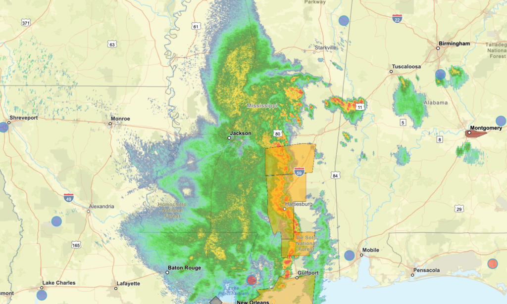
The storm coming into the area tonight is expected to bring heavy rain, strong winds, and a small chance of hail. Some storms may be severe with a couple already signaling off tornado warnings, so be weather aware. The Storm Prediction Center had issued a Slight Risk for the western area (2 out of 5 risk for severe weather), so the chance of severe storms is greater. The lows for the evening will be in the lower 70s with partly cloudy skies once the storm moves through.
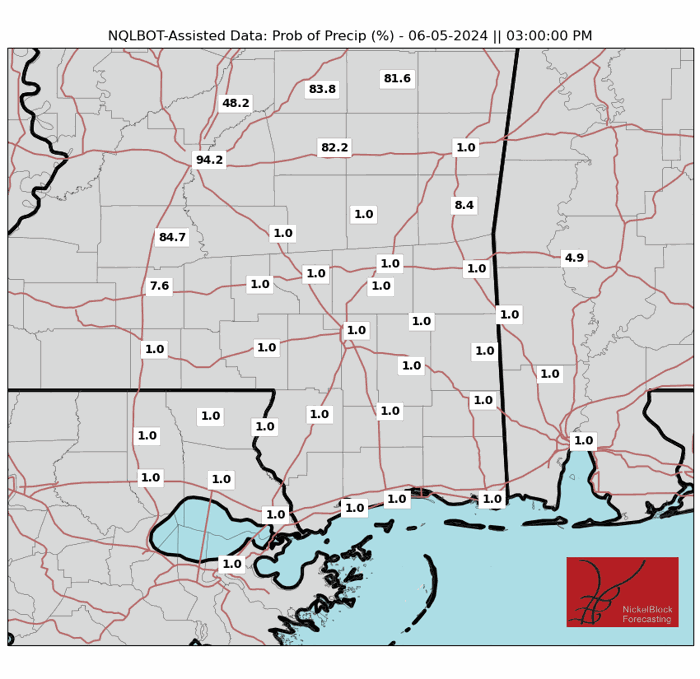
Moving to Wednesday, a cold front will be pushing through from the plains towards our area bringing a chance for thunderstorms. There is a Marginal Risk for severe weather in the area (1 out of 5 risk for severe weather) with the main threats being damaging wind gusts. The chance for rain is greater in the northern part of our area, as signified in the image below. The highs for the day will be in the lower 90s with mostly cloudy skies as the front moves in.
For the rest of the week, there will be a consistent possibility for showers. The heat will remain in the 90s, so prepare for yet another hot and dry week. A cooling trend should be starting at the beginning of next week thanks to another cold front, but the temperatures will only slightly decrease.
REGIONAL DAY TO DAY FORECAST:
Tonight: Partly cloudy with a chance of showers/thunderstorms later in the evening, then mostly cloudy after midnight. Lows in the lower 70s. 5 to 10 mph winds to the south. 40 percent chance of rain.
Wednesday: Mostly sunny. A chance of showers/thunderstorms in the afternoon. Highs around 90. 5 to 10 mph winds to the south. 30 percent chance of rain.
Wednesday Night: Partly cloudy in the evening, then becoming mostly cloudy. A chance of showers/thunderstorms. Lows in the lower 70s. 5 to 10 mph winds to the southwest. Chance of rain 30 percent.
Thursday: Mostly sunny. Small chance for showers/thunderstorms in the morning, then a chance for them in the afternoon as well. Highs around the lower 90s. 5 to 10 mph winds to the west. 40 percent chance of rain.
Thursday Night: Mostly clear. A slight chance of showers and thunderstorms in the evening. Lows in the lower 70s. 20 percent chance of rain.
Friday: Sunny. A slight chance of showers and thunderstorms in the afternoon. Highs in the mid 90s. 20 percent chance of rain.
Friday Night: Mostly clear. Lows in the upper 60s.
Saturday: Sunny. Highs in the lower 90s.
Saturday Night: Mostly clear. Lows in the upper 60s.
Sunday: Sunny. A small chance for showers and thunderstorms in the afternoon. Highs in the lower 90s. 20 percent chance of rain.
Sunday Night: Partly cloudy. A slight chance of showers and thunderstorms. Lows in the lower 70s. 20 percent chance of rain.
Monday: Mostly sunny. Small chance for showers/thunderstorms in the morning, then a chance for them in the afternoon as well. Highs in the lower 90s. 30 percent chance of rain.
Monday Night: Partly Cloudy. Lows in the lower 70s.


