Many of us experienced another round of showers and thunderstorms this afternoon and evening. As this shortwave trough moves over the Gulf Coast, it will begin to separate from a larger trough across the northern Great Lakes, which will help weaken storms and leave us with a few showers overnight.
Rain chances will decrease from west to east on Thursday morning as a weak cold front moves through the region. I’d recommend leaving for work a couple minutes earlier than usual in case you get caught in one of these showers. A few strong storms near the I-59 corridor can’t be ruled out, however, we are confident that most storms won’t be severe.
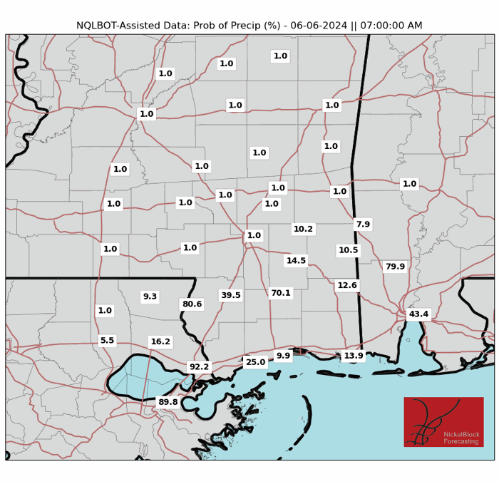
Mostly sunny conditions will be present during the afternoon hours as the temperature and dewpoint are forecasted to slowly fall, leaving a great opportunity to get done any outdoor activities.
Friday will be quiet, with the front stalling near Hwy 84. Even though dew points will be in the upper 60s to low 70s, the afternoon high temperature will still top out around 90F. High pressure will help keep conditions dry for Saturday.
By Sunday afternoon and evening, moisture will increase again, leading to a chance of rain and storms as another shortwave trough passes through. There is some uncertainty about the severity of these storms, so continue to check future forecasts on our website.
Next week, another trough is forecasted to move southward across the eastern U.S. as a stalled front should keep rain chances low until mid-week.
REGIONAL DAY TO DAY FORECAST
Today: Mostly sunny. A chance of showers and thunderstorms this afternoon. Highs around 90. South winds 5 to 10 mph. Chance of rain 40 percent.
Tonight: Mostly cloudy with a chance of showers and thunderstorms. Lows in the lower 70s. Southwest winds 5 to 10 mph. Chance of rain 40 percent.
Thursday: Mostly sunny. A chance of showers and thunderstorms in the morning, then showers and thunderstorms likely in the afternoon. Highs around 90. West winds 5 to 10 mph. Chance of rain 70 percent.
Thursday Night: Mostly clear. Lows around 70. West winds around 5 mph in the evening, becoming light and variable.
Friday: Sunny. Highs in the mid 90s. Northwest winds 5 to 10 mph.
Friday Night: Mostly clear. Lows in the mid 60s.
Saturday: Sunny. Highs in the lower 90s.
Saturday Night: Mostly clear. Lows around 70.
Sunday: Sunny. A slight chance of showers and thunderstorms in the afternoon. Highs in the mid 90s. Chance of rain 20 percent.
Sunday Night: Mostly clear. A slight chance of showers and thunderstorms in the evening, then a chance of showers and thunderstorms after midnight. Lows in the lower 70s. Chance of rain 30 percent.
Monday: Mostly sunny. A slight chance of showers and thunderstorms in the morning, then a chance of showers and thunderstorms in the afternoon. Highs in the lower 90s. Chance of rain 40 percent.
Monday Night: Partly cloudy with a chance of showers and thunderstorms in the evening, then mostly cloudy with a slight chance of showers and thunderstorms after midnight. Lows in the upper 60s. Chance of rain 40 percent.
Tuesday: Mostly sunny. A slight chance of showers and thunderstorms in the morning, then a chance of showers and thunderstorms in the afternoon. Highs in the upper 80s. Chance of rain 40 percent.


