High pressure is building into the area which should help to slow those winds down a bit as we move into the overnight hours. Low temperatures tonight will drop into 30s. Some folks may even see a light frost.

The next shot for rain is right around the corner. By Saturday we will see another shot for showers and storms. Right now, severe weather doesn’t look likely, but it is worth monitoring for an outside shot we see one or two storms pulse past severe-weather-thresholds.
Rain may linger into Sunday. Then things look drier Monday. But then another shot for rain arrives on Tuesday.
Gulf Coast weather at its finest! One or the other. We are either begging for rain, or get it all too often.
REGIONAL DAY TO DAY FORECAST
Tonight: Clear. Patchy frost after midnight. Lows in the lower 30s. Northwest winds around 5 mph.
Thursday: Patchy frost in the morning. Sunny. Highs in the upper 50s. Northeast winds around 5 mph.
Thursday Night: Partly cloudy. Patchy frost after midnight. Lows in the upper 30s. East winds around 5 mph.
Friday: Partly sunny. Highs in the lower 60s. East winds 5 to 10 mph.
Friday Night: Partly cloudy. Not as cool with lows in the upper 40s.
Saturday: Mostly cloudy. A slight chance of showers in the morning, then a chance of showers in the afternoon. Highs in the upper 60s. Chance of rain 40 percent.
Saturday Night: Mostly cloudy with a 50 percent chance of showers. Lows in the mid 50s.
Sunday: Partly sunny with a 20 percent chance of showers. Highs in the lower 70s.
Sunday Night: Partly cloudy. Lows in the lower 50s.
Monday: Partly sunny. Highs in the lower 70s.
Monday Night: Partly cloudy in the evening, then becoming mostly cloudy. A 20 percent chance of showers. Lows in the lower 50s.
Tuesday: Partly sunny with a 20 percent chance of showers. Highs in the upper 60s.
CHRISTMAS FORECAST
Some of you guys may recall my post from back on November 21st, offering a bit of a “first look” at the Christmas forecast.
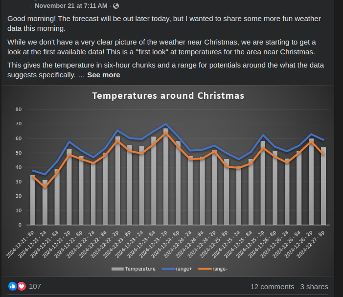
A lot of that was based off the anticipated weather patterns and overall regime blended with a fair bit of climatology.
The original forecast was given in ranges. It showed a chilly Christmas Even with a morning temperature barely cooler than the afternoon high – between about 45 and 55 all day. Then, the Christmas forecast was showing a range of 40-45 in the morning and 55-65 in the afternoon. Sure the chart does offer a specific number, but it just an average of the range I could derive from a lot of the “big picture” stuff.
Fast forward three weeks! We are just now getting within range of the actual model guidance. That means more than just patterns and climatology.
The 15-Day outlook shows 40 on Christmas Eve morning and 59 in the afternoon and suggests 47 in the morning and 66 in the afternoon for Christmas Day.
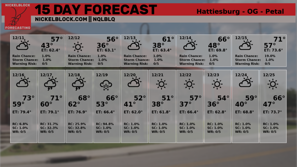
Honestly, not far from my forecast three weeks ago. It also shows a handful of chilly days leading up to Christmas as we move through the weekend prior to Christmas.
The reason we may be chilly ahead of the week of Christmas has to do with where the big ridges of high pressure and low pressure may be aligned.
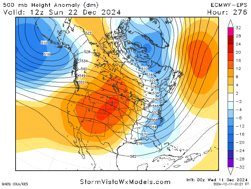
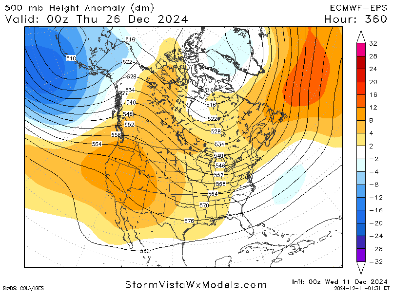
Right now the model guidance that looks out that far shows a trough (blue shading) over the area around December 22 (the map above, on left) that is replaced by more ridging by overnight December 25th and into the 26th (red shading) in the map above and on the right.
When looking at these maps of condition at 500mb (about 20,000ft aloft), a trough usually means cooler temperatures and ridging usually indicates warmer temperatures.
Can this change?
Absolutely.
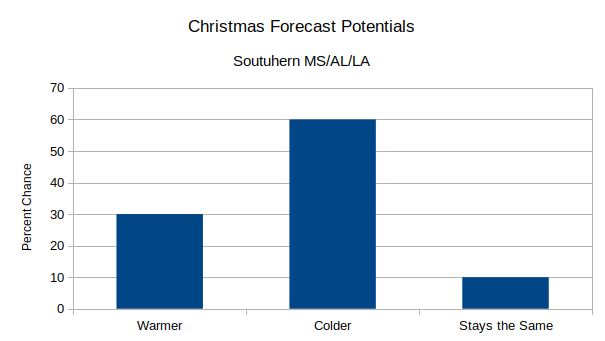
The one thing these models do pretty well is picking out the general pattern (warm vs. cold) but they are less good at picking out *when* things will happen specifically. So, that cooler air may linger a bit longer and hang around on Christmas Day. Or it may be here and gone, and the warmer weather mat last a bit longer.
We will know more in the coming days as we see more and more model guidance rendered to look at these outcomes.
For now, it looks like the forecast from a few weeks ago still holds. But there is a decent chance we end up a bit cooler. And a smaller chance we end up a bit warmer. So far, no indications that there will be severe weather around Christmas.
And, sorry kids, it looks like the chance for snow on Christmas is near zero.
I’ll continue to monitor this in the coming days, though, just to make sure….

