Tropical Storm Francine is slowly gaining strength as it moves northward across the Gulf of Mexico. This will result in easterly winds of 10-15 mph in our area, with increasing humidity and rising chances for rain throughout the day and night. Although rain rates are expected to be light, heavier showers can’t be ruled out.
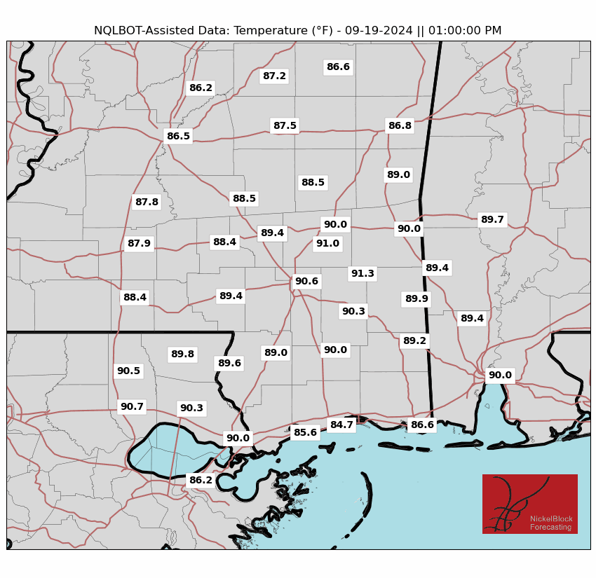
Temperatures will beheld in check the next few days given the increased cloud cover and chance for rain. Our NQLBOT-assissted weather forecast may be slightly too cool, but I do think that we will definitely avoid the 90s. But most folks I think top out around 80 today and in the 70s tomorrow.

The storm is expected to strengthen into a hurricane later today and reach Category 2 strength before making landfall along the Louisiana coast on Wednesday afternoon.

Heavy rainfall and strong winds, particularly in central Louisiana and southwestern Mississippi, are anticipated Wednesday and into Thursday. the National Hurricane Center shows that Tropical Storm-force wind will begin during the day on Wednesday across much of the area. Wind will begin Wednesday night for places farther north.

Rainfall totals of 4-6 inches or more are possible, and Sustained wind between 30-50 mph as the storm passes through, with isolated areas seeing gusts during the rainbands over 60 mph.
For the latest county-by-county breakdown for Francine, follow this link
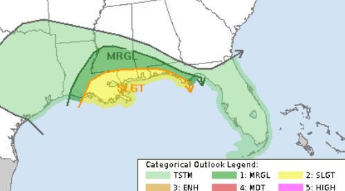
Additionally, there is a Marginal Risk and Slight Risk for tornadoes, especially in bands of precipitation across eastern Mississippi and western Alabama on Thursday.
By Friday, Francine’s remnants will bring lingering light rain, but conditions will gradually improve through the weekend. Highs will remain in the 80s with muggy conditions, and lows will settle in the 60s.
REGIONAL DAY TO DAY FORECAST
Today: Mostly cloudy with a chance of thunderstorms. A chance of showers this morning, then showers likely this afternoon. Highs around 80. East winds 5 to 10 mph. Chance of rain 40 percent.
Tonight: Mostly cloudy with a chance of showers and thunderstorms. Lows in the upper 60s. East winds 5 to 10 mph. Chance of rain 40 percent.
Wednesday: Rain. Locally heavy rainfall possible in the afternoon. Highs in the mid 70s. East winds 10 to 15 mph with gusts up to 25 mph. Chance of rain near 100 percent.
Wednesday Night: A chance of thunderstorms. Showers. Locally heavy rainfall possible in the evening. Near steady temperature in the lower 70s. East winds 15 to 20 mph with gusts up to 35 mph. Chance of rain near 100 percent.
Thursday: A chance of thunderstorms. Showers likely, mainly in the morning. Humid with highs in the mid 80s. South winds 15 to 20 mph with gusts up to 30 mph. Chance of rain 70 percent.
Thursday Night: Partly cloudy. A chance of showers and thunderstorms in the evening. Lows in the upper 60s. Chance of rain 50 percent.
Friday: Mostly sunny. Highs in the mid 80s.
Friday Night: Mostly clear. Lows in the upper 60s.
Saturday: Mostly sunny. Highs in the upper 80s.
Saturday Night: Partly cloudy in the evening, then becoming mostly cloudy. Lows in the upper 60s.
Sunday: Mostly sunny. Highs in the upper 80s.
Sunday Night: Partly cloudy. Lows in the upper 60s.
Monday: Mostly sunny. A slight chance of showers and thunderstorms in the afternoon. Highs in the upper 80s. Chance of rain 20 percent.


