The latest from the NHC shows that Tropical Storm Francine is still floating around the southwestern Gulf and has not started to move northeast quite yet. The forecast from the NHC shows the Tropical Storm strengthening into a Hurricane – a Category 2 Hurricane – before landfall.
Landfall is expect to happen on Wednesday.
The timeline on the arrival of Tropical Storm-force wind is shown in the graphic below.

Looking at local impacts. I have it broken down into three Zones.
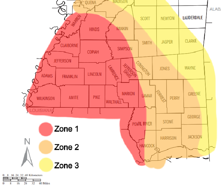
Zone 1: Highest sustained wind speeds and highest wind gusts, highest tornado threat, and some of the heaviest rain with highest totals — up to 9″ of rain.
Zone 2: Still strong wind with sustained wind speeds Tropical Storm strength, Wind gusts up to 70mph, tornado threat with Tornado Watch likely, rainfall totals between 4-7 inches.
Zone 3: Sustained wind speeds not damaging, but wind gusts strong enough to cause damage under strongest rainbands and storms, tornado threat with Tornado Watch Possible, rainfall totals between 2-5 inches.
Below is the county-by-county breakdown. This is the first one. So there will likely be changes tomorrow night. So please take this for now, but check back for an update.
Along I-20
Rankin County:
8a — 12p – As things get started, a few isolated storms are possible. A few may be severe. The main concerns are brief heavy rain, some lightning, gusty wind, small hail. Rainfall totals up to 1 inch possible.
12p — 9p – There is a chance for showers and storms. Some severe. the main concerns are heavy rain, wind gusts up to 70mph, and a few tornadoes (up to EF2 in strength). Rainfall totals are estimated to be around 4-7 inches.
9p — 1a – All Clear! Though, there is a chance for some lingering brief heavy rain, some lightning, gusty wind, small hail. Rainfall totals up to 1 inch possible.
How it will impact you:
– Roads may be briefly impassable due to short-term flash flooding
– Trees may be knocked down, and scattered power outages are likely
– A Tornado Watch is possible
Best to be where you want to be by 11a
Scott County:
8a — 12p – As things get started, a few isolated storms are possible. A few may be severe. The main concerns are brief heavy rain, some lightning, gusty wind, small hail. Rainfall totals up to 1 inch possible.
12p — 9p – There is a chance for showers and storms. Some severe. the main concerns are heavy rain, wind gusts up to 65mph, and a few tornadoes (up to EF2 in strength). Rainfall totals are estimated to be around 4-7 inches.
9p — 1a – All Clear! Though, there is a chance for some lingering brief heavy rain, some lightning, gusty wind, small hail. Rainfall totals up to 1 inch possible.
How it will impact you:
– Roads may be briefly impassable due to short-term flash flooding
– Trees may be knocked down, and scattered power outages are likely
– A Tornado Watch is possible
Best to be where you want to be by 11a
Newton County:
8a — 12p – As things get started, a few isolated storms are possible. A few may be severe. The main concerns are brief heavy rain, some lightning, gusty wind, small hail. Rainfall totals up to 1 inch possible.
12p — 9p – There is a chance for showers and storms. Some severe. the main concerns are heavy rain, wind gusts up to 65mph, and a few tornadoes (up to EF2 in strength). Rainfall totals are estimated to be around 4-7 inches.
9p — 1a – All Clear! Though, there is a chance for some lingering brief heavy rain, some lightning, gusty wind, small hail. Rainfall totals up to 1 inch possible.
How it will impact you:
– Roads may be briefly impassable due to short-term flash flooding
– Trees may be knocked down, and scattered power outages are likely
– A Tornado Watch is possible
Best to be where you want to be by 11a
Lauderdale County:
8a — 12p – As things get started, a few isolated storms are possible. A few may be severe. The main concerns are brief heavy rain, some lightning, gusty wind, small hail. Rainfall totals up to 1 inch possible.
12p — 9p – There is a chance for showers and storms. Some severe. the main concerns are heavy rain, wind gusts up to 60mph, and a few tornadoes (up to EF2 in strength). Rainfall totals are estimated to be around 4-7 inches.
9p — 1a – All Clear! Though, there is a chance for some lingering brief heavy rain, some lightning, gusty wind, small hail. Rainfall totals up to 1 inch possible.
How it will impact you:
– Roads may be briefly impassable due to short-term flash flooding
– Trees may be knocked down, and scattered power outages are likely
– A Tornado Watch is possible
Best to be where you want to be by 11a
Near I-20
Copiah County:
8a — 12p – As things get started, a few isolated storms are possible. A few may be severe. The main concerns are brief heavy rain, some lightning, gusty wind, small hail. Rainfall totals up to 1 inch possible.
12p — 9p – There is a chance for showers and storms. Some severe. the main concerns are heavy rain, wind gusts up to 70mph, and a few tornadoes (up to EF2 in strength). Rainfall totals are estimated to be around 4-7 inches.
9p — 1a – All Clear! Though, there is a chance for some lingering brief heavy rain, some lightning, gusty wind, small hail. Rainfall totals up to 1 inch possible.
How it will impact you:
– Roads may be briefly impassable due to short-term flash flooding
– Trees may be knocked down, and scattered power outages are likely
– A Tornado Watch is likely
Best to be where you want to be by 11a
Simpson County:
8a — 12p – As things get started, a few isolated storms are possible. A few may be severe. The main concerns are brief heavy rain, some lightning, gusty wind, small hail. Rainfall totals up to 1 inch possible.
12p — 9p – There is a chance for showers and storms. Some severe. the main concerns are heavy rain, wind gusts up to 70mph, and a few tornadoes (up to EF2 in strength). Rainfall totals are estimated to be around 4-7 inches.
9p — 1a – All Clear! Though, there is a chance for some lingering brief heavy rain, some lightning, gusty wind, small hail. Rainfall totals up to 1 inch possible.
How it will impact you:
– Roads may be briefly impassable due to short-term flash flooding
– Trees may be knocked down, and scattered power outages are likely
– A Tornado Watch is likely
Best to be where you want to be by 11a
Smith County:
8a — 12p – As things get started, a few isolated storms are possible. A few may be severe. The main concerns are brief heavy rain, some lightning, gusty wind, small hail. Rainfall totals up to 1 inch possible.
12p — 9p – There is a chance for showers and storms. Some severe. the main concerns are heavy rain, wind gusts up to 65mph, and a few tornadoes (up to EF2 in strength). Rainfall totals are estimated to be around 4-7 inches.
9p — 1a – All Clear! Though, there is a chance for some lingering brief heavy rain, some lightning, gusty wind, small hail. Rainfall totals up to 1 inch possible.
How it will impact you:
– Roads may be briefly impassable due to short-term flash flooding
– Trees may be knocked down, and scattered power outages are likely
– A Tornado Watch is possible
Best to be where you want to be by 11a
Jasper County:
8a — 12p – As things get started, a few isolated storms are possible. A few may be severe. The main concerns are brief heavy rain, some lightning, gusty wind, small hail. Rainfall totals up to 1 inch possible.
12p — 9p – There is a chance for showers and storms. Some severe. the main concerns are heavy rain, wind gusts up to 65mph, and a few tornadoes (up to EF2 in strength). Rainfall totals are estimated to be around 4-7 inches.
9p — 1a – All Clear! Though, there is a chance for some lingering brief heavy rain, some lightning, gusty wind, small hail. Rainfall totals up to 1 inch possible.
How it will impact you:
– Roads may be briefly impassable due to short-term flash flooding
– Trees may be knocked down, and scattered power outages are likely
– A Tornado Watch is possible
Best to be where you want to be by 11a
Clarke County:
8a — 12p – As things get started, a few isolated storms are possible. A few may be severe. The main concerns are brief heavy rain, some lightning, gusty wind, small hail. Rainfall totals up to 1 inch possible.
12p — 9p – There is a chance for showers and storms. Some severe. the main concerns are heavy rain, wind gusts up to 60mph, and a few tornadoes (up to EF2 in strength). Rainfall totals are estimated to be around 4-7 inches.
9p — 1a – All Clear! Though, there is a chance for some lingering brief heavy rain, some lightning, gusty wind, small hail. Rainfall totals up to 1 inch possible.
How it will impact you:
– Roads may be briefly impassable due to short-term flash flooding
– Trees may be knocked down, and scattered power outages are likely
– A Tornado Watch is possible
Best to be where you want to be by 11a
HWY 84 Corridor
Lincoln County:
8a — 11a – As things get started, a few isolated storms are possible. A few may be severe. The main concerns are brief heavy rain, some lightning, gusty wind, small hail. Rainfall totals up to 1 inch possible.
11a — 8p – There is a chance for showers and storms. Some severe. the main concerns are heavy rain, wind gusts up to 75mph, and a few tornadoes (up to EF2 in strength). Rainfall totals are estimated to be around 4-7 inches.
8p — 12a – All Clear! Though, there is a chance for some lingering brief heavy rain, some lightning, gusty wind, small hail. Rainfall totals up to 1 inch possible.
How it will impact you:
– Roads may be briefly impassable due to short-term flash flooding
– Trees may be knocked down, and scattered power outages are likely
– A Tornado Watch is likely
Best to be where you want to be by 10a
Lawrence County:
8a — 11a – As things get started, a few isolated storms are possible. A few may be severe. The main concerns are brief heavy rain, some lightning, gusty wind, small hail. Rainfall totals up to 1 inch possible.
11a — 8p – There is a chance for showers and storms. Some severe. the main concerns are heavy rain, wind gusts up to 75mph, and a few tornadoes (up to EF2 in strength). Rainfall totals are estimated to be around 4-7 inches.
8p — 12a – All Clear! Though, there is a chance for some lingering brief heavy rain, some lightning, gusty wind, small hail. Rainfall totals up to 1 inch possible.
How it will impact you:
– Roads may be briefly impassable due to short-term flash flooding
– Trees may be knocked down, and scattered power outages are likely
– A Tornado Watch is likely
Best to be where you want to be by 10a
Jeff Davis County:
8a — 11a – As things get started, a few isolated storms are possible. A few may be severe. The main concerns are brief heavy rain, some lightning, gusty wind, small hail. Rainfall totals up to 1 inch possible.
11a — 8p – There is a chance for showers and storms. Some severe. the main concerns are heavy rain, wind gusts up to 75mph, and a few tornadoes (up to EF2 in strength). Rainfall totals are estimated to be around 4-7 inches.
8p — 12a – All Clear! Though, there is a chance for some lingering brief heavy rain, some lightning, gusty wind, small hail. Rainfall totals up to 1 inch possible.
How it will impact you:
– Roads may be briefly impassable due to short-term flash flooding
– Trees may be knocked down, and scattered power outages are likely
– A Tornado Watch is likely
Best to be where you want to be by 10a
Covington County:
8a — 11a – As things get started, a few isolated storms are possible. A few may be severe. The main concerns are brief heavy rain, some lightning, gusty wind, small hail. Rainfall totals up to 1 inch possible.
11a — 8p – There is a chance for showers and storms. Some severe. the main concerns are heavy rain, wind gusts up to 70mph, and a few tornadoes (up to EF2 in strength). Rainfall totals are estimated to be around 4-7 inches.
8p — 12a – All Clear! Though, there is a chance for some lingering brief heavy rain, some lightning, gusty wind, small hail. Rainfall totals up to 1 inch possible.
How it will impact you:
– Roads may be briefly impassable due to short-term flash flooding
– Trees may be knocked down, and scattered power outages are likely
– A Tornado Watch is likely
Best to be where you want to be by 10a
Jones County:
8a — 11a – As things get started, a few isolated storms are possible. A few may be severe. The main concerns are brief heavy rain, some lightning, gusty wind, small hail. Rainfall totals up to 1 inch possible.
11a — 8p – There is a chance for showers and storms. Some severe. the main concerns are heavy rain, wind gusts up to 70mph, and a few tornadoes (up to EF2 in strength). Rainfall totals are estimated to be around 4-7 inches.
8p — 12a – All Clear! Though, there is a chance for some lingering brief heavy rain, some lightning, gusty wind, small hail. Rainfall totals up to 1 inch possible.
How it will impact you:
– Roads may be briefly impassable due to short-term flash flooding
– Trees may be knocked down, and scattered power outages are likely
– A Tornado Watch is likely
Best to be where you want to be by 10a
Wayne County:
8a — 11a – As things get started, a few isolated storms are possible. A few may be severe. The main concerns are brief heavy rain, some lightning, gusty wind, small hail. Rainfall totals up to 1 inch possible.
11a — 8p – There is a chance for showers and storms. Some severe. the main concerns are heavy rain, wind gusts up to 65mph, and a few tornadoes (up to EF2 in strength). Rainfall totals are estimated to be around 4-7 inches.
8p — 12a – All Clear! Though, there is a chance for some lingering brief heavy rain, some lightning, gusty wind, small hail. Rainfall totals up to 1 inch possible.
How it will impact you:
– Roads may be briefly impassable due to short-term flash flooding
– Trees may be knocked down, and scattered power outages are likely
– A Tornado Watch is possible
Best to be where you want to be by 10a
HWY 98 Corridor
Pike County:
6a — 10a – As things get started, a few isolated storms are possible. A few may be severe. The main concerns are brief heavy rain, some lightning, gusty wind, small hail. Rainfall totals up to 1 inch possible.
10a — 6p – There is a chance for showers and storms. Some severe. the main concerns are heavy rain, wind gusts up to 75mph, and a few tornadoes (up to EF2 in strength). Rainfall totals are estimated to be around 4-7 inches.
6p — 10p – All Clear! Though, there is a chance for some lingering brief heavy rain, some lightning, gusty wind, small hail. Rainfall totals up to 1 inch possible.
How it will impact you:
– Roads may be briefly impassable due to short-term flash flooding
– Trees may be knocked down, and scattered power outages are likely
– A Tornado Watch is likely
Best to be where you want to be by 9a
Walthall County:
6a — 10a – As things get started, a few isolated storms are possible. A few may be severe. The main concerns are brief heavy rain, some lightning, gusty wind, small hail. Rainfall totals up to 1 inch possible.
10a — 6p – There is a chance for showers and storms. Some severe. the main concerns are heavy rain, wind gusts up to 75mph, and a few tornadoes (up to EF2 in strength). Rainfall totals are estimated to be around 4-7 inches.
6p — 10p – All Clear! Though, there is a chance for some lingering brief heavy rain, some lightning, gusty wind, small hail. Rainfall totals up to 1 inch possible.
How it will impact you:
– Roads may be briefly impassable due to short-term flash flooding
– Trees may be knocked down, and scattered power outages are likely
– A Tornado Watch is likely
Best to be where you want to be by 9a
Marion County:
6a — 10a – As things get started, a few isolated storms are possible. A few may be severe. The main concerns are brief heavy rain, some lightning, gusty wind, small hail. Rainfall totals up to 1 inch possible.
10a — 6p – There is a chance for showers and storms. Some severe. the main concerns are heavy rain, wind gusts up to 75mph, and a few tornadoes (up to EF2 in strength). Rainfall totals are estimated to be around 4-7 inches.
6p — 10p – All Clear! Though, there is a chance for some lingering brief heavy rain, some lightning, gusty wind, small hail. Rainfall totals up to 1 inch possible.
How it will impact you:
– Roads may be briefly impassable due to short-term flash flooding
– Trees may be knocked down, and scattered power outages are likely
– A Tornado Watch is likely
Best to be where you want to be by 9a
Lamar County:
6a — 10a – As things get started, a few isolated storms are possible. A few may be severe. The main concerns are brief heavy rain, some lightning, gusty wind, small hail. Rainfall totals up to 1 inch possible.
10a — 6p – There is a chance for showers and storms. Some severe. the main concerns are heavy rain, wind gusts up to 75mph, and a few tornadoes (up to EF2 in strength). Rainfall totals are estimated to be around 4-7 inches.
6p — 10p – All Clear! Though, there is a chance for some lingering brief heavy rain, some lightning, gusty wind, small hail. Rainfall totals up to 1 inch possible.
How it will impact you:
– Roads may be briefly impassable due to short-term flash flooding
– Trees may be knocked down, and scattered power outages are likely
– A Tornado Watch is likely
Best to be where you want to be by 9a
Forrest County:
6a — 10a – As things get started, a few isolated storms are possible. A few may be severe. The main concerns are brief heavy rain, some lightning, gusty wind, small hail. Rainfall totals up to 1 inch possible.
10a — 6p – There is a chance for showers and storms. Some severe. the main concerns are heavy rain, wind gusts up to 70mph, and a few tornadoes (up to EF2 in strength). Rainfall totals are estimated to be around 4-7 inches.
6p — 10p – All Clear! Though, there is a chance for some lingering brief heavy rain, some lightning, gusty wind, small hail. Rainfall totals up to 1 inch possible.
How it will impact you:
– Roads may be briefly impassable due to short-term flash flooding
– Trees may be knocked down, and scattered power outages are likely
– A Tornado Watch is likely
Best to be where you want to be by 9a
Perry County:
6a — 10a – As things get started, a few isolated storms are possible. A few may be severe. The main concerns are brief heavy rain, some lightning, gusty wind, small hail. Rainfall totals up to 1 inch possible.
10a — 6p – There is a chance for showers and storms. Some severe. the main concerns are heavy rain, wind gusts up to 70mph, and a few tornadoes (up to EF2 in strength). Rainfall totals are estimated to be around 4-7 inches.
6p — 10p – All Clear! Though, there is a chance for some lingering brief heavy rain, some lightning, gusty wind, small hail. Rainfall totals up to 1 inch possible.
How it will impact you:
– Roads may be briefly impassable due to short-term flash flooding
– Trees may be knocked down, and scattered power outages are likely
– A Tornado Watch is possible
Best to be where you want to be by 9a
Greene County:
6a — 10a – As things get started, a few isolated storms are possible. A few may be severe. The main concerns are brief heavy rain, some lightning, gusty wind, small hail. Rainfall totals up to 1 inch possible.
10a — 6p – There is a chance for showers and storms. Some severe. the main concerns are heavy rain, wind gusts up to 70mph, and a few tornadoes (up to EF2 in strength). Rainfall totals are estimated to be around 4-7 inches.
6p — 10p – All Clear! Though, there is a chance for some lingering brief heavy rain, some lightning, gusty wind, small hail. Rainfall totals up to 1 inch possible.
How it will impact you:
– Roads may be briefly impassable due to short-term flash flooding
– Trees may be knocked down, and scattered power outages are likely
– A Tornado Watch is possible
Best to be where you want to be by 9a
HWY 26 Corridor
Pearl River County:
6a — 10a – As things get started, a few isolated storms are possible. A few may be severe. The main concerns are brief heavy rain, some lightning, gusty wind, small hail. Rainfall totals up to 1 inch possible.
10a — 6p – There is a chance for showers and storms. Some severe. the main concerns are heavy rain, wind gusts up to 75mph, and a few tornadoes (up to EF2 in strength). Rainfall totals are estimated to be around 4-7 inches.
6p — 10p – All Clear! Though, there is a chance for some lingering brief heavy rain, some lightning, gusty wind, small hail. Rainfall totals up to 1 inch possible.
How it will impact you:
– Roads may be briefly impassable due to short-term flash flooding
– Trees may be knocked down, and scattered power outages are likely
– A Tornado Watch is likely
Best to be where you want to be by 9a
Stone County:
6a — 10a – As things get started, a few isolated storms are possible. A few may be severe. The main concerns are brief heavy rain, some lightning, gusty wind, small hail. Rainfall totals up to 1 inch possible.
10a — 6p – There is a chance for showers and storms. Some severe. the main concerns are heavy rain, wind gusts up to 70mph, and a few tornadoes (up to EF2 in strength). Rainfall totals are estimated to be around 4-7 inches.
6p — 10p – All Clear! Though, there is a chance for some lingering brief heavy rain, some lightning, gusty wind, small hail. Rainfall totals up to 1 inch possible.
How it will impact you:
– Roads may be briefly impassable due to short-term flash flooding
– Trees may be knocked down, and scattered power outages are likely
– A Tornado Watch is possible
Best to be where you want to be by 9a
George County:
6a — 10a – As things get started, a few isolated storms are possible. A few may be severe. The main concerns are brief heavy rain, some lightning, gusty wind, small hail. Rainfall totals up to 1 inch possible.
10a — 6p – There is a chance for showers and storms. Some severe. the main concerns are heavy rain, wind gusts up to 65mph, and a few tornadoes (up to EF2 in strength). Rainfall totals are estimated to be around 4-7 inches.
6p — 10p – All Clear! Though, there is a chance for some lingering brief heavy rain, some lightning, gusty wind, small hail. Rainfall totals up to 1 inch possible.
How it will impact you:
– Roads may be briefly impassable due to short-term flash flooding
– Trees may be knocked down, and scattered power outages are likely
– A Tornado Watch is possible
Best to be where you want to be by 9a
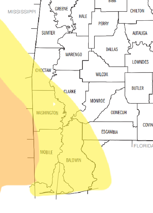
MISSISSIPPI COAST
Hancock County:
6a — 10a – As things get started, a few isolated storms are possible. A few may be severe. The main concerns are brief heavy rain, some lightning, gusty wind, small hail. Rainfall totals up to 1 inch possible.
10a — 6p – There is a chance for showers and storms. Some severe. the main concerns are heavy rain, wind gusts up to 75mph, and a few tornadoes (up to EF2 in strength). Rainfall totals are estimated to be around 4-7 inches.
6p — 10p – All Clear! Though, there is a chance for some lingering brief heavy rain, some lightning, gusty wind, small hail. Rainfall totals up to 1 inch possible.
How it will impact you:
– Roads may be briefly impassable due to short-term flash flooding
– Trees may be knocked down, and scattered power outages are likely
– A Tornado Watch is likely
Best to be where you want to be by 9a
Harrison County:
6a — 10a – As things get started, a few isolated storms are possible. A few may be severe. The main concerns are brief heavy rain, some lightning, gusty wind, small hail. Rainfall totals up to 1 inch possible.
10a — 6p – There is a chance for showers and storms. Some severe. the main concerns are heavy rain, wind gusts up to 75mph, and a few tornadoes (up to EF2 in strength). Rainfall totals are estimated to be around 4-7 inches.
6p — 10p – All Clear! Though, there is a chance for some lingering brief heavy rain, some lightning, gusty wind, small hail. Rainfall totals up to 1 inch possible.
How it will impact you:
– Roads may be briefly impassable due to short-term flash flooding
– Trees may be knocked down, and scattered power outages are likely
– A Tornado Watch is likely
Best to be where you want to be by 9a
Jackson County:
6a — 10a – As things get started, a few isolated storms are possible. A few may be severe. The main concerns are brief heavy rain, some lightning, gusty wind, small hail. Rainfall totals up to 1 inch possible.
10a — 6p – There is a chance for showers and storms. Some severe. the main concerns are heavy rain, wind gusts up to 75mph, and a few tornadoes (up to EF2 in strength). Rainfall totals are estimated to be around 4-7 inches.
6p — 10p – All Clear! Though, there is a chance for some lingering brief heavy rain, some lightning, gusty wind, small hail. Rainfall totals up to 1 inch possible.
How it will impact you:
– Roads may be briefly impassable due to short-term flash flooding
– Trees may be knocked down, and scattered power outages are likely
– A Tornado Watch is possible
Best to be where you want to be by 9a
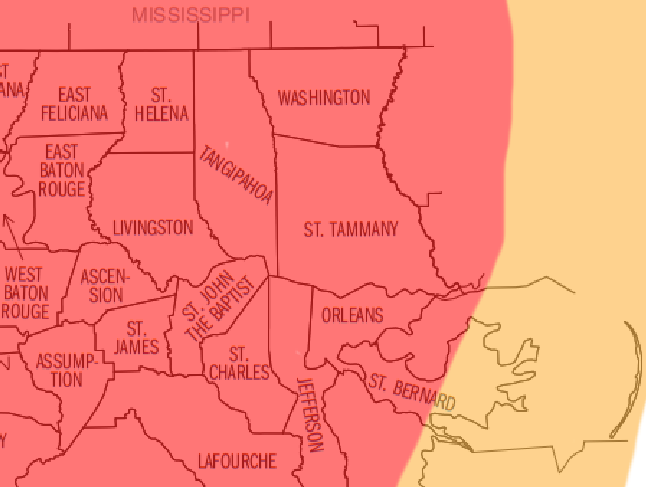
LOUISIANA PARISHES
Saint Helena Parish
5a — 9a – As things get started, a few isolated storms are possible. A few may be severe. The main concerns are brief heavy rain, some lightning, gusty wind, small hail. Rainfall totals up to 1 inch possible.
9a — 5p – There is a chance for showers and storms. Some severe. the main concerns are heavy rain, wind gusts up to 80mph, and a few tornadoes (up to EF2 in strength). Rainfall totals are estimated to be around 4-7 inches.
5p — 9p – All Clear! Though, there is a chance for some lingering brief heavy rain, some lightning, gusty wind, small hail. Rainfall totals up to 1 inch possible.
How it will impact you:
– Roads may be briefly impassable due to short-term flash flooding
– Trees may be knocked down, and scattered power outages are likely
– A Tornado Watch is likely
Best to be where you want to be by 8a
Livingston Parish
5a — 9a – As things get started, a few isolated storms are possible. A few may be severe. The main concerns are brief heavy rain, some lightning, gusty wind, small hail. Rainfall totals up to 1 inch possible.
9a — 5p – There is a chance for showers and storms. Some severe. the main concerns are heavy rain, wind gusts up to 80mph, and a few tornadoes (up to EF2 in strength). Rainfall totals are estimated to be around 4-7 inches.
5p — 9p – All Clear! Though, there is a chance for some lingering brief heavy rain, some lightning, gusty wind, small hail. Rainfall totals up to 1 inch possible.
How it will impact you:
– Roads may be briefly impassable due to short-term flash flooding
– Trees may be knocked down, and scattered power outages are likely
– A Tornado Watch is likely
Best to be where you want to be by 8a
Tangipahoa Parish
5a — 9a – As things get started, a few isolated storms are possible. A few may be severe. The main concerns are brief heavy rain, some lightning, gusty wind, small hail. Rainfall totals up to 1 inch possible.
9a — 5p – There is a chance for showers and storms. Some severe. the main concerns are heavy rain, wind gusts up to 80mph, and a few tornadoes (up to EF2 in strength). Rainfall totals are estimated to be around 4-7 inches.
5p — 9p – All Clear! Though, there is a chance for some lingering brief heavy rain, some lightning, gusty wind, small hail. Rainfall totals up to 1 inch possible.
How it will impact you:
– Roads may be briefly impassable due to short-term flash flooding
– Trees may be knocked down, and scattered power outages are likely
– A Tornado Watch is likely
Best to be where you want to be by 8a
Washington Parish
5a — 9a – As things get started, a few isolated storms are possible. A few may be severe. The main concerns are brief heavy rain, some lightning, gusty wind, small hail. Rainfall totals up to 1 inch possible.
9a — 5p – There is a chance for showers and storms. Some severe. the main concerns are heavy rain, wind gusts up to 80mph, and a few tornadoes (up to EF2 in strength). Rainfall totals are estimated to be around 4-7 inches.
5p — 9p – All Clear! Though, there is a chance for some lingering brief heavy rain, some lightning, gusty wind, small hail. Rainfall totals up to 1 inch possible.
How it will impact you:
– Roads may be briefly impassable due to short-term flash flooding
– Trees may be knocked down, and scattered power outages are likely
– A Tornado Watch is likely
Best to be where you want to be by 8a
Saint Tammany Parish
5a — 9a – As things get started, a few isolated storms are possible. A few may be severe. The main concerns are brief heavy rain, some lightning, gusty wind, small hail. Rainfall totals up to 1 inch possible.
9a — 5p – There is a chance for showers and storms. Some severe. the main concerns are heavy rain, wind gusts up to 80mph, and a few tornadoes (up to EF2 in strength). Rainfall totals are estimated to be around 4-7 inches.
5p — 9p – All Clear! Though, there is a chance for some lingering brief heavy rain, some lightning, gusty wind, small hail. Rainfall totals up to 1 inch possible.
How it will impact you:
– Roads may be briefly impassable due to short-term flash flooding
– Trees may be knocked down, and scattered power outages are likely
– A Tornado Watch is likely
Best to be where you want to be by 8a
Orleans Parish
5a — 9a – As things get started, a few isolated storms are possible. A few may be severe. The main concerns are brief heavy rain, some lightning, gusty wind, small hail. Rainfall totals up to 1 inch possible.
9a — 5p – There is a chance for showers and storms. Some severe. the main concerns are heavy rain, wind gusts up to 85mph, and a few tornadoes (up to EF2 in strength). Rainfall totals are estimated to be around 4-7 inches.
5p — 9p – All Clear! Though, there is a chance for some lingering brief heavy rain, some lightning, gusty wind, small hail. Rainfall totals up to 1 inch possible.
How it will impact you:
– Roads may be briefly impassable due to short-term flash flooding
– Trees may be knocked down, and scattered power outages are likely
– A Tornado Watch is likely
Best to be where you want to be by 8a
ALABAMA COUNTIES
Choctaw County:
6a — 11a – As things get started, a few isolated storms are possible. A few may be severe. The main concerns are brief heavy rain, some lightning, gusty wind, small hail. Rainfall totals up to 1 inch possible.
11a — 8p – There is a chance for showers and storms. Some severe. the main concerns are heavy rain, wind gusts up to 55mph, and a few tornadoes (up to EF2 in strength). Rainfall totals are estimated to be around 4-7 inches.
8p — 11p – All Clear! Though, there is a chance for some lingering brief heavy rain, some lightning, gusty wind, small hail. Rainfall totals up to 1 inch possible.
How it will impact you:
– Roads may be briefly impassable due to short-term flash flooding
– Trees may be knocked down, and scattered power outages are likely
– A Tornado Watch is possible
Best to be where you want to be by 10a
Washington County:
6a — 10a – As things get started, a few isolated storms are possible. A few may be severe. The main concerns are brief heavy rain, some lightning, gusty wind, small hail. Rainfall totals up to 1 inch possible.
10a — 7p – There is a chance for showers and storms. Some severe. the main concerns are heavy rain, wind gusts up to 60mph, and a few tornadoes (up to EF2 in strength). Rainfall totals are estimated to be around 4-7 inches.
7p — 11p – All Clear! Though, there is a chance for some lingering brief heavy rain, some lightning, gusty wind, small hail. Rainfall totals up to 1 inch possible.
How it will impact you:
– Roads may be briefly impassable due to short-term flash flooding
– Trees may be knocked down, and scattered power outages are likely
– A Tornado Watch is possible
Best to be where you want to be by 9a
Mobile County:
6a — 10a – As things get started, a few isolated storms are possible. A few may be severe. The main concerns are brief heavy rain, some lightning, gusty wind, small hail. Rainfall totals up to 1 inch possible.
10a — 7p – There is a chance for showers and storms. Some severe. the main concerns are heavy rain, wind gusts up to 65mph, and a few tornadoes (up to EF2 in strength). Rainfall totals are estimated to be around 4-7 inches.
7p — 11p – All Clear! Though, there is a chance for some lingering brief heavy rain, some lightning, gusty wind, small hail. Rainfall totals up to 1 inch possible.
How it will impact you:
– Roads may be briefly impassable due to short-term flash flooding
– Trees may be knocked down, and scattered power outages are likely
– A Tornado Watch is possible
Best to be where you want to be by 9a


One thought on “9/9/24 815p — County-by-County breakdown for Tropical Storm Francine for SE Louisiana, Southern Mississippi, and SW Alabama”
Comments are closed.