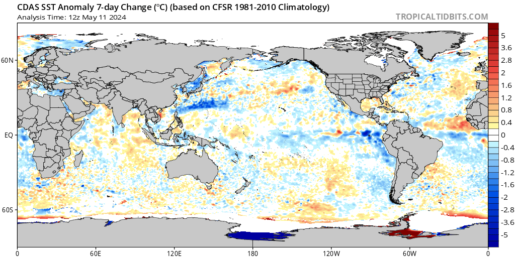
It is an interesting start to the week with tropical activity finally starting to start in the Atlantic while disturbances are continuing to bustle in the Eastern Pacific. We are currently looking at one disturbance in the Eastern Pacific expecting to develop further in the next couple days. Meanwhile, we are finally seeing a disturbance in the Central Atlantic. This is just the beginning of this disturbance so tune in for an extended outlook for this week.
The Eastern Pacific

Sitting off of the Eastern Coast of Mexico is one tropical disturbance (Invest 94E) with currently a 70% chance of formation over the next 48 hours with chances near 90% over the next week. Environmental conditions are favorable for this development with relatively low shear ahead of the storm. However, relative shear in the Eastern Pacific anomalously slightly higher than average which is why we are not seeing these strong cyclones form. Luckily, this collection of thunderstorms is headed almost directly west, possibly turning slightly north. Thus, this storm should not affect inland besides the current thunderstorms as of Monday night.

There is decent model agreement among the GFS Ensemble that this disturbance will strengthen to a category 1 hurricane as it follows a similar path to many of the storms we have seen in the Pacific last week.

Waters along the NA coast in the Eastern Pacific have also gotten slightly cooler over the past week. This will also hinder any strong development for hurricanes along this region while the Central Atlantic has been warming up a bit over the past week which has allowed for more organized convection to occur.
The Atlantic Basin

Meanwhile in the Central Atlantic, we are finally seeing the beginning developments of a possible tropical storm. It has been awhile since we have seen any activity in the Atlantic, this is pretty typical for the early hurricane season while the Atlantic is still warming up for the Summer. But we do have a disturbance (Invest 95W) in the Central Atlantic with currently a 40% chance of formation over the next 7 days. It is expected to travel east, dipping slightly south before most likely curving back north.

This disturbance will not likely develop very strongly as there will be strong influx of dry air along the backend of the storm from the north. This will limit much of the convection needed for any hurricane-strength winds.
Extended Outlook

A strong ridge will continue to reign over the Northern Atlantic as we look further into hurricane season for possible Atlantic development. However, some models within the ensemble that is also somewhat present in the map above is the slight anomalous trough along the Eastern Atlantic that could spark some tropical disturbances later this month.
Conclusions
Overall, these tropical storms are nothing to worry about in terms of danger to the mainland US or Mexico but it will interesting to see how far these storms will continue to develop over the next several days. While the rest of our areas of interest such the Gulf and Central Pacific remain calm for the time being, we will continue to look ahead for some possible disturbances as September gets closer.

