Introduction: Wind is a dynamic force that shapes our weather patterns and influences our daily lives. In Part 8 of our weather education series, we’ll explore the world of wind and air masses, uncovering how they are formed, their role in meteorology, and how they contribute to the movement of weather systems.
Understanding Wind: Wind is the movement of air in the atmosphere. It occurs as air flows from areas of high pressure to areas of low pressure. Wind can vary in speed, direction, and intensity, and it plays a pivotal role in determining weather conditions.

Factors Influencing Wind Patterns: Several factors influence wind patterns:
- Pressure Systems: Differences in atmospheric pressure drive the movement of air. Air flows from regions of high pressure to regions of low pressure, creating wind patterns.
- Coriolis Effect: The rotation of the Earth causes moving air masses to curve as they travel. In the Northern Hemisphere, air curves to the right, while in the Southern Hemisphere, it curves to the left. This phenomenon, known as the Coriolis effect, affects global wind patterns.
- Topography: Mountains, valleys, and bodies of water can influence local wind patterns. For example, mountains can block or redirect the flow of air, leading to variations in wind direction and intensity.
Air Masses: Air masses are large volumes of air that have similar temperature and humidity characteristics throughout. They can cover extensive geographic areas and play a crucial role in weather patterns. There are several types of air masses:
- Maritime Polar (mP): These air masses originate over cold ocean waters and bring cool, moist conditions.
- Continental Polar (cP): Originating over cold landmasses, these air masses bring cold and dry conditions.
- Maritime Tropical (mT): Forming over warm ocean waters, these air masses bring warm and humid conditions.
- Continental Tropical (cT): Originating over hot and dry land areas, these air masses bring hot and dry conditions.
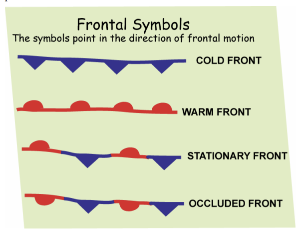
Fronts and Weather Systems: When different air masses collide, they create weather fronts, which are boundaries separating air masses with different temperature and humidity characteristics. There are four main types of fronts:
- Cold Front: Occurs when a cold air mass pushes under a warm air mass, leading to potentially severe weather, such as thunderstorms.
- Warm Front: Occurs when a warm air mass overtakes a cold air mass, bringing milder conditions and precipitation.
- Stationary Front: Forms when two air masses with different temperatures meet but neither one displaces the other. This can lead to prolonged periods of rain or drizzle.
- Occluded Front: Occurs when a fast-moving cold front overtakes a warm front, lifting the warm air mass above the cold air mass. This can result in a variety of weather conditions.

Take Home: Wind and air masses are fundamental components of meteorology. When the local TV meteorologist talks about an air mass change, it often comes with a drastic change in weather conditions. Air masses play a critical role in shaping weather patterns, influencing temperature and humidity, and creating the conditions for weather fronts and systems to form. By understanding these concepts, meteorologists can predict weather changes and provide valuable information for our daily lives.
In our next post, we’ll delve into weather forecasting methods and the tools used by meteorologists to predict future weather conditions. If you have any questions or topics you’d like us to cover in this series, please feel free to reach out. Stay curious, and stay tuned for more weather insights!


One thought on “Exploring Meteorology: Part 8 – Air Masses”
Comments are closed.