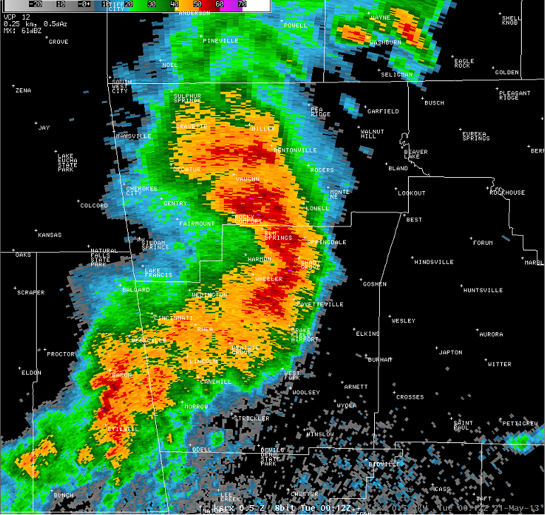
Introduction: Mesoscale Convective Systems (MCSs) are expansive, organized collections of thunderstorms that can dominate weather patterns across large areas, particularly noted for their impact in the central and southern United States.
Characteristics of Mesoscale Convective Systems: MCSs are distinguished by several key features that make them unique among atmospheric phenomena:
- Size and Duration: MCSs can span hundreds of miles in diameter and last for more than 12 hours, making them much larger and longer-lasting than typical thunderstorms.
- Structure: These systems can form various structures, including bow echoes, squall lines, and circular derechos, each contributing differently to weather patterns.
- Intense Weather: MCSs are known for producing severe weather conditions, including heavy rainfall, strong winds, hail, and occasionally tornadoes.
- Classification by Structure: MCSs are often described as either linear or nonlinear:
- Linear MCSs: These feature a convective line — a contiguous or nearly contiguous chain of convective echoes with a nearly common leading edge moving in tandem. These can be straight or moderately curved.
- Nonlinear MCSs: Characterized by large, eccentric precipitation patterns without convective lines, these MCSs exhibit more irregular shapes and behaviors.

Formation of Mesoscale Convective Systems: The development of MCSs is tied to specific atmospheric conditions:
- Instability and Moisture: Ample atmospheric moisture and significant instability are crucial for the formation of MCSs. These conditions often arise where warm, moist air meets cooler air, providing the energy needed for storms.
- Lifting Mechanisms: MCSs often form along weather fronts or where there are significant topographical features that encourage air to rise, initiating condensation and storm development.
- Forward Motion: The forward movement of an MCS is often driven by the cold pool, an area of cooled air at the surface that forms under the MCS due to the evaporation of rain. This cold pool can push the system forward, influencing its speed and direction of travel.
- Warm Sector vs. Non-Warm Sector MCSs:
- Warm Sector (WS) MCSs: These occur in the warm, moist, typically conditionally unstable air masses demarcated by synoptic fronts, known as warm sectors.
- Non-Warm Sector (non-WS) MCSs: These form on the cold side of a synoptic-scale warm or stationary front.

What is the Rear-Inflow Jet?
The rear-inflow jet is a current of relatively fast-moving air that flows into the rear part of an MCS. It usually originates aloft and descends towards the surface as it moves into the MCS. This jet is typically cooler and drier compared to the surrounding air.
Interaction with an MCS:
- Enhancement of Downdrafts: As the rear-inflow jet descends and encounters the warmer air near the surface at the back of the MCS, it can enhance the downdrafts. This process can lead to more intense and concentrated outflows at the surface, particularly at the leading edge of the system.
- Squall Line Formation and Maintenance: The interaction of the rear-inflow jet with the updrafts and downdrafts within the MCS helps maintain the structure of the squall line. By providing a continuous influx of momentum and cooler air, the rear-inflow jet contributes to the longevity and intensity of the squall line.
- Influence on Propagation: The rear-inflow jet can influence the forward speed and direction of the MCS. It often accelerates the system and can enhance the leading edge, making the system more efficient in its propagation.
Take Home: MCSs are vast, organized clusters of thunderstorms that can impact a large area over a short period of time. MCSs are characterized by a distinct structure with multiple individual thunderstorms organized into a cohesive system.
They often form in regions with favorable atmospheric conditions, such as abundant low-level moisture and instability, along with a triggering mechanism like a frontal boundary or upper-level disturbance.MCSs can persist for several hours, sometimes lasting overnight, and can produce a variety of severe weather phenomena, including heavy rainfall, flash flooding, damaging winds, large hail, and even tornadoes. Due to their large size and longevity, MCSs can affect large regions.


How do I download nickel block forecasting?
Just head to your app store and search for “nickelblock forecasting” or my name, Nick Lilja. Or you can follow this link: https://www.nickelblock.com/downloading-the-nickelblock-forecasting-app/ for instructions.