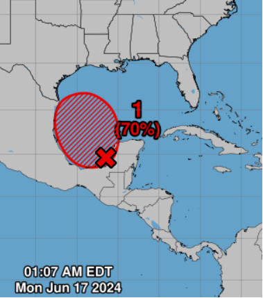
9AM CORRECTION: We now have “Invest 91L” in the Bay of Campeche. This replaces “90E” mentioned below as the area of interest.
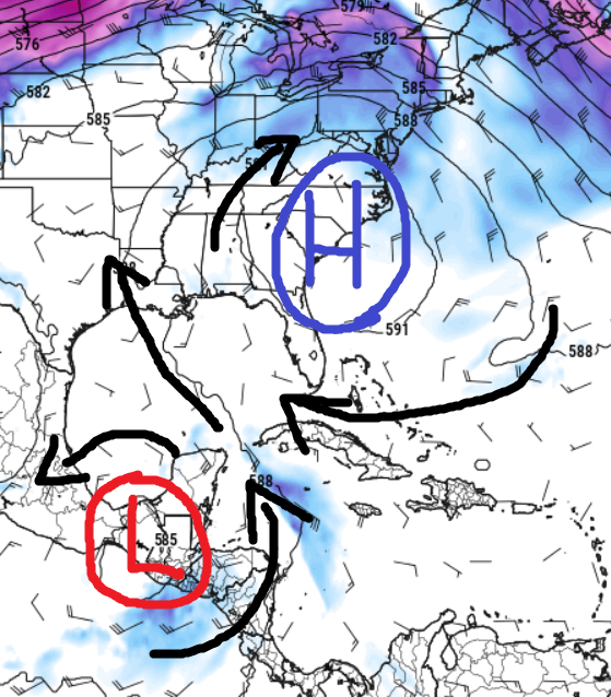
The Central American Gyre is hard at work this morning producing “areas of interest” near the Yucatan for us to monitor. One area of interest, Invest 90E, continues to churn. The reason it is “90E” and not “91L” is because the center of the area to watch actually started in the Pacific.
It won’t directly impact our area, but the Central American Gyre and Invest 90E will fling some tropical moisture our direction through the next 48 hours. This flinging will also be influenced by a ridge of high pressure to our east.
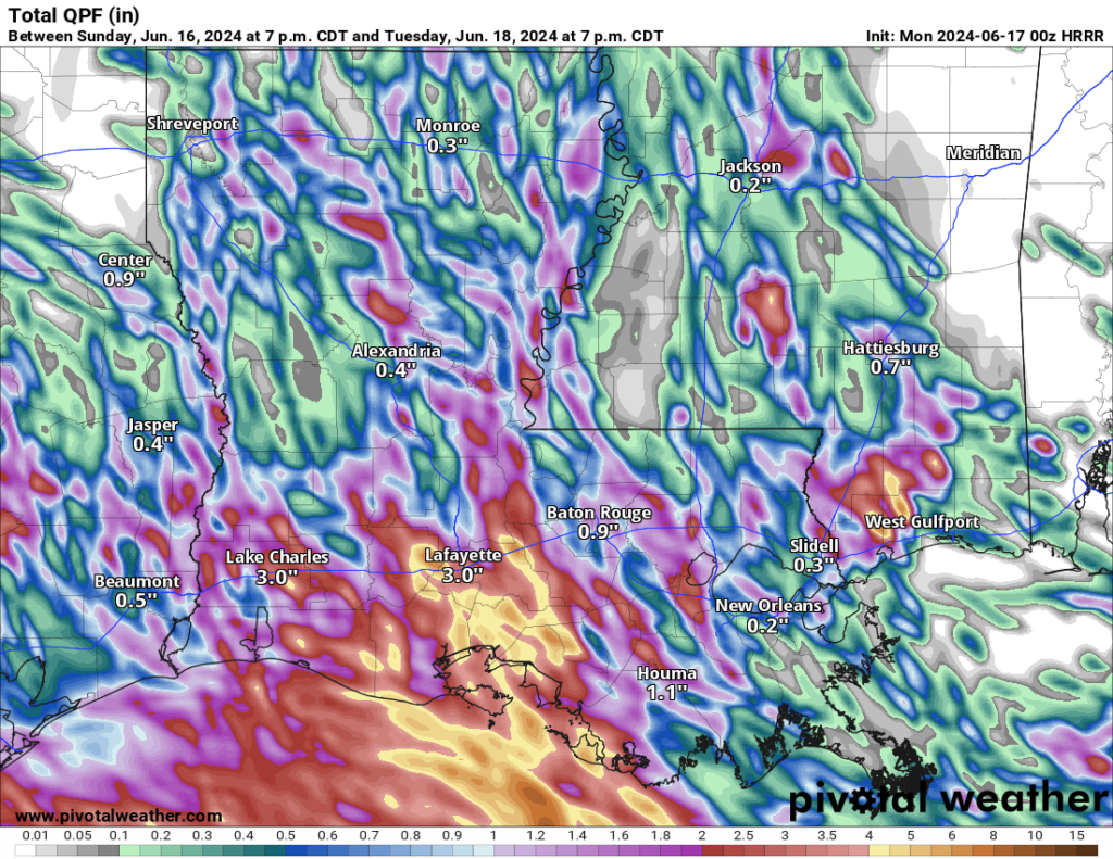
As the day heats up, combined with the CAG nearby and the ridge to the east, we expect widespread, off-and-on, showers and thunderstorms. While some areas might see heavy rain, it should move quickly enough to avoid major flooding. Some places might get a few inches of rain, but it shouldn’t cause significant problems. Tomorrow we will continue with the same pattern and forecast.
Rainfall totals shown above, on the right, have pockets of 2″ to 4″ of rain, but most of the widespread heavier rain is down along the Louisiana coastline.
Speaking of the area of low pressure down in the southern Gulf, the NHC now categorizes Invest 90E with a “high” chance for tropical development. Meaning that we should see this organize itself into a Tropical Depression during the next few days.
Regardless of the movement of the tropical riff-raff in the Bay of Campeche, we should start to dry out by Wednesday. This is partially due to the added organization down there and the ridge of high pressure shifting east, easing up on the funnel of moisture being pointed at our area. And even if the tropical ‘whatever’ tracks more to the north, we should be far enough away that we should see fewer storms in the area, regardless.
By this upcoming weekend, we may be monitoring another area in the caribbean for potential development as well as keeping our eyes to the north for a late-season cold front to try and push through next week.
REGIONAL DAY TO DAY FORECAST
Today: Partly sunny with a slight chance of showers and thunderstorms this morning, then mostly cloudy with showers with thunderstorms likely this afternoon. Highs in the upper 80s. East winds 5 to 10 mph. Chance of rain 60 percent.
Tonight: Mostly cloudy. Showers and thunderstorms likely in the evening. Lows in the lower 70s. East winds 5 to 10 mph. Chance of rain 50 percent.
Tuesday: Mostly cloudy. A slight chance of showers and thunderstorms in the morning, then a chance of showers and thunderstorms in the afternoon. Highs in the upper 80s. East winds 10 to 15 mph with gusts up to 25 mph. Chance of rain 40 percent.
Tuesday Night: Mostly cloudy. A slight chance of showers after midnight. Lows in the mid 70s. East winds 5 to 10 mph. Chance of rain 20 percent.
Juneteenth: Partly sunny. A slight chance of showers and thunderstorms in the morning, then a chance of showers and thunderstorms in the afternoon. Highs in the lower 90s. East winds 10 to 15 mph with gusts up to 25 mph. Chance of rain 30 percent.
Wednesday Night: Mostly cloudy in the evening, then becoming partly cloudy. Lows in the lower 70s.
Thursday: Mostly sunny. A slight chance of showers and thunderstorms in the afternoon. Highs in the lower 90s. Chance of rain 20 percent.
Thursday Night: Partly cloudy in the evening, then becoming mostly clear. Lows in the lower 70s.
Friday: Sunny. A slight chance of showers and thunderstorms in the morning, then a chance of showers and thunderstorms in the afternoon. Highs in the mid 90s. Chance of rain 30 percent.
Friday Night: Mostly clear. Lows in the lower 70s.
Saturday: Sunny. A chance of showers and thunderstorms in the afternoon. Highs in the mid 90s. Chance of rain 30 percent.
Saturday Night: Mostly clear. Lows in the lower 70s.
Sunday: Sunny. A slight chance of showers and thunderstorms in the morning, then a chance of showers and thunderstorms in the afternoon. Highs in the mid 90s. Chance of rain 40 percent.


