After a seasonably warm week and two rounds of storms, we are back to Winter again! The winter sky was out in full force with no clouds and cool temperatures today, and we’ll be fairly cool tonight and warmer tomorrow. Let’s take a look!
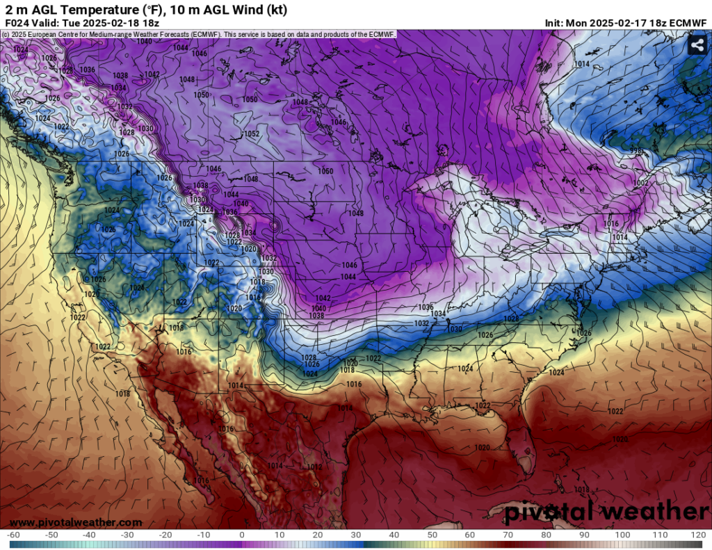
There’s a lot going on with the map above. You can see there’s a ton of extremely cold temperatures across the northern plains and even parts of Texas who are all under an extreme cold warning. This is due to a massive surface high pressure zone over Canada bringing in the Arctic air. Currently, we’re on the back side of another high pressure zone in the Atlantic, but this will soon move further out after a low pressure out of the southern Rockies moves in.
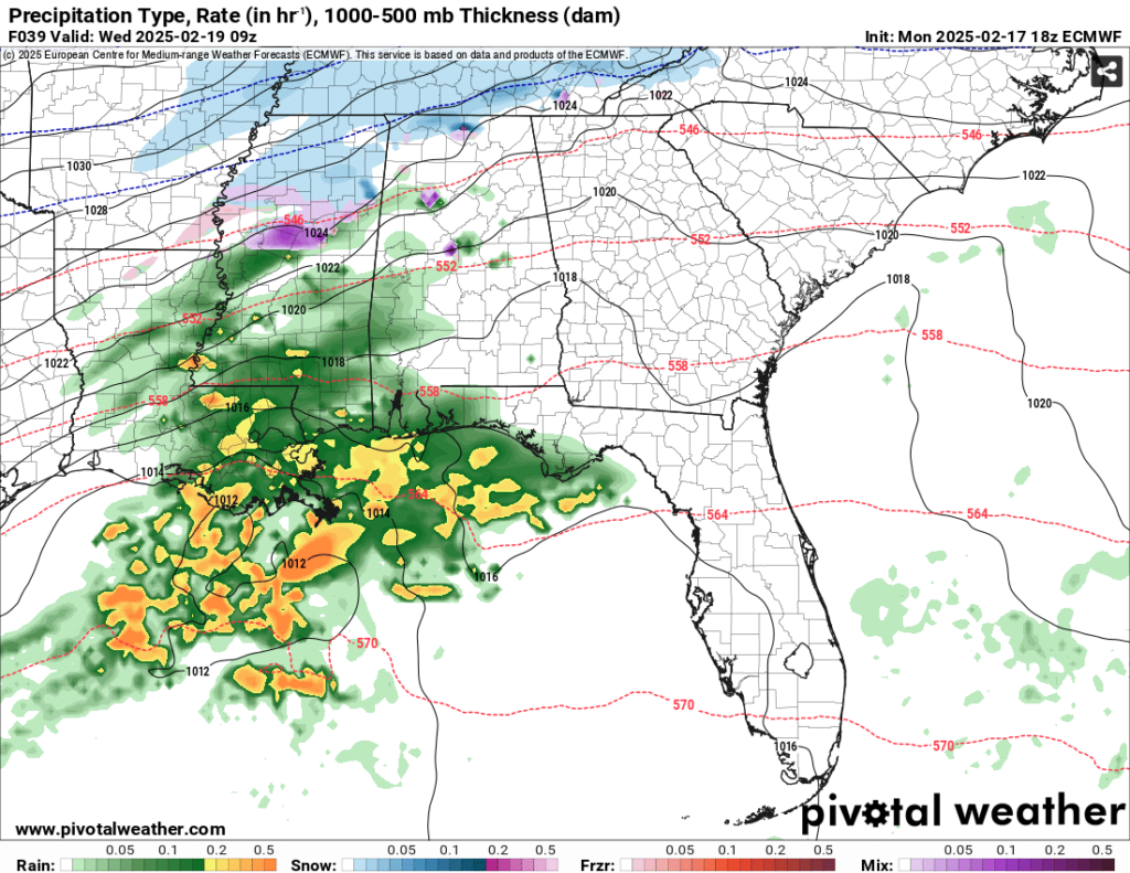
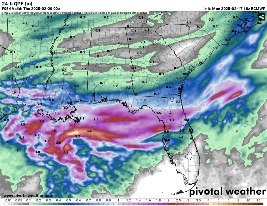
We’ll have a day of slightly warmer temperatures on Tuesday with highs in the 50s across the area before our next system moves in. The low will dip further south due to the Arctic air and bring much of the rain to the Gulf, Louisiana and the lower half of Mississippi and Alabama. The upper half may have some mixed precipitation to contend with due to the ground temperatures near the freezing mark. Our neighbors to the north in north Mississippi and Tennessee may see another round of snow! This looks to arrive in the later evening hours Tuesday evening for Louisiana and reach Mississippi by midnight. Most of this will be out by the mid-morning, but we’ll likely get a decent amount of rain from a quarter to three quarters of an inch in southern Mississippi.
Wednesday will be quite windy and reach the upper 40s, however it might not feel like it due to the wind gusts. The Arctic air will make its way down to us during the day and it’ll be bitterly cold overnight. Temperatures will fall into the low 20s and wind chills will reach the low teens. The three P’s: pets, plants, and pipes bring them in and cover them because I’m sure a hard freeze warning is coming for Thursday morning. Thursday will be a similar story with north winds blowing in and temperatures just reaching the upper 30s to low 40s. Overnight, we’ll reach the mid 20s with wind chills in the mid teens.
As the Arctic air moves towards the Hudson bay on Friday, we’ll begin to warm up a tad with the winds reducing to around 5mph from the north northeast. Temperatures will reach the upper 40s during the day and around the freezing mark overnight. Clouds will begin to roll in to begin the weekend.
Select Data Set:

Regional Day-to-Day Forecast
Tonight – Mostly clear, with a low in the mid 30s. Calm wind.
Tuesday – Increasing clouds, with a high in the low 60s. Calm wind becoming east around 5 mph in the morning.
Tuesday Night – Rain starting in the evening. Low in the low 40s. East wind 5 to 10 mph becoming north northeast after midnight. Chance of precipitation is 100%. New precipitation amounts between 1 and 2 inches possible.
Wednesday – Showers until the mid morning then lingering until noon. Cloudy, with a high near 50. North wind 10 to 15 mph, with gusts as high as 20 mph. Chance of precipitation is 40%.
Wednesday Night – Mostly cloudy, with a low in the low 20s. Wind chills near 10. North wind around 15 mph, with gusts as high as 25 mph.
Thursday – Sunny, with a high in the upper 30s to around 40. North wind around 15 mph, with gusts as high as 25 mph.
Thursday Night – Clear, with a low in the low 20s. North northeast wind 5 to 10 mph.
Friday – Mostly sunny, with a high near 50. North northeast wind around 5 mph.
Friday Night – Mostly cloudy, with a low in the low 30s. Calm wind.
Saturday – A 20 percent chance of showers. Mostly cloudy, with a high in the low to mid 50s.
Saturday Night – A 30 percent chance of showers. Mostly cloudy, with a low in the mid 30s.
Sunday – A 20 percent chance of showers. Mostly sunny, with a high in the low 60s.
Sunday Night – Partly cloudy, with a low in the upper 30s.
Monday – Sunny, with a high near 70.


