Good morning! The main story is, you guessed it, the heat! Not much else is going on at the moment, so that’s pretty much the main story for today.
Taking a look at the surface observations from last night, I sketched in a couple of features that are important to look at.

There is a low pressure centered over the TX/OK panhandle, with a stationary front extending out into the Carolinas.
The low pressure is responsible for setting up Southerly flow, keeping much of the Southeast hot and humid. Even though 7pm is well after the peak heating, Wichita Falls, TX recorded 103F, and Fort Smith, AR hit 102F. This is some serious heat! Heat Advisories and some Excessive Heat Warnings are in effect, as heat indices may reach up to 110F or 115F in some of the purple areas of NE OK.

The stationary front, interacting with southerly humid flow, resulted in horrible flash flooding in the Saint Louis metro area yesterday morning.

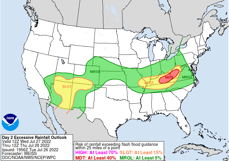
Today’s Flash Flooding Risk // Courtesy: WPC 
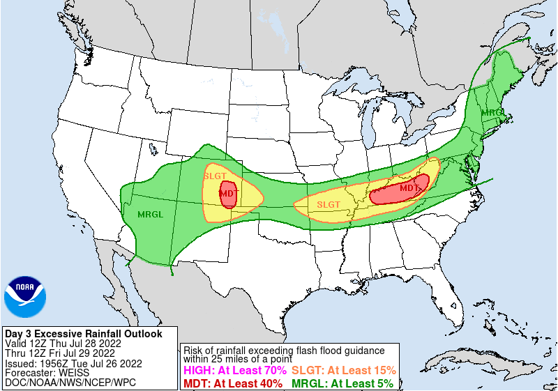
Tomorrow’s Flash Flooding Risk // Courtesy: WPC
The WPC does continue this flash flooding risk into the remainder of this week, with risks of flash flooding currently in place for portions of the Ohio/Tennessee Valleys, as well as the Northern Ozarks. Much of the “Southeast” proper isn’t included, however, as our weather will be influenced by the other major player. High pressure, marked in blue, is dominating across the Southern portion of the region.

Looking at the upper level flow across the country, it’s easy to see why a lot of the Southeast has lower rain chances-big upper level high pressures will be dominating the area and keeping most of the rain on the outside of the major ridge.
This hotter and drier pattern is set to persist over the coming days, as will the flooding risk in KY/TN/MO.
Check out the 5-day rainfall forecast from the WPC! It’s very clear which areas will be wet, and which areas will be dry.

Basically, our pattern is set to be in a kind of gridlock, with patterns sitting and persisting.
This is really not good for anyone, with wet areas seeing more and more rainfall, leading to enhanced flooding threats, and dry areas seeing more and more hot and dry weather, leading to enhanced drought.

The drought monitor from last week does show a stark picture for Texas, with 99% of the state in a drought, and Oklahoma, which is completely under a strong drought. Even beyond that, the entire state of Arkansas is also under some form of drought or abnormal dryness. The ‘South’ Region, pictured here, is 92.7% covered in drought. At this same time last year, just 5.4% of this region was in drought! What difference a year makes!
No matter what way you slice it, this pattern can be detrimental to agriculture, which will probably be proven in a couple of weeks. I wish there was a way to move some of the Missouri Valley rains further South, but this was the hand we were dealt.
3-day Southeast City Forecast
| Dallas, TX | ||
| Wednesday | Thursday | Friday |
| High: 102F | High: 102F | High: 102F |
| Low: 81F | Low: 82F | Low: 79F |
| Precip: None | Precip: None | Precip: None |
| Houston, TX | ||
| Wednesday | Thursday | Friday |
| High: 96F | High: 96F | High: 97F |
| Low: 80F | Low: 80F | Low: 79F |
| Precip: 40% | Precip: 30% | Precip: 40% |
| New Orleans, LA | ||
| Wednesday | Thursday | Friday |
| High: 90F | High: 89F | High: 90F |
| Low: 80F | Low: 79F | Low: 79F |
| Precip: 50% | Precip: 70% | Precip: 70% |
| Little Rock, AR | ||
| Wednesday | Thursday | Friday |
| High: 99F | High: 97F | High: 86F |
| Low: 80F | Low: 78F | Low: 72F |
| Precip: 20% | Precip: 40% | Precip: 80% |
| Memphis, TN | ||
| Wednesday | Thursday | Friday |
| High: 98F | High: 96F | High: 89F |
| Low: 80F | Low: 78F | Low: 73F |
| Precip: 30% | Precip: 40% | Precip: 80% |
| Birmingham, AL | ||
| Wednesday | Thursday | Friday |
| High: 94F | High: 94F | High: 92F |
| Low: 76F | Low: 75F | Low: 75F |
| Precip: 10% | Precip: 20% | Precip: 70% |
| Atlanta, GA | ||
| Wednesday | Thursday | Friday |
| High: 92F | High: 92F | High: 91F |
| Low: 76F | Low: 75F | Low: 74F |
| Precip: 20% | Precip: 20% | Precip: 50% |

