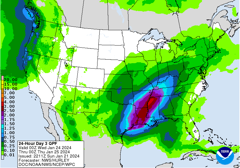
This will be a discussion on some observations I’ve made on the medium range models looking at the rainfall and the duration of the event.


First of all, let’s look at the two flagship models, the European and GFS, for tracking where the rainfall totals may fall. The Euro model places the stalled front further west towards the ArkLaTex region with the most rain near the far northeastern Texas to western Arkansas and Louisiana area. The GFS places a more general straight line of 5+ inch rain totals from the Houston area all the way to the MissAlTenn border. Areas further east towards the Pinebelt to Jackson area may see an average of at least 2+ inches regardless of the setup. Areas in Alabama will see at least 1.5 to 3.5 inches as the front moves slowly forward.

Going by the Weather Prediction Center’s observations, this stationary front looks to move enough day by day to bring heavy rain to a different region. However, most of the heaviest rain looks to hit around Arkansas, Texas, Louisiana, and parts of Mississippi. Several disturbances will help feed the rain and many long periods of heavy rain will be possible. Considering the WPC’s outlook, this looks to bring the heaviest rain a little further east compared to the Euro. The front’s final form begins around Wednesday into Thursday as it matures which will bring a much more structured line of storms as the upper levels will help guide it along.

All this to say that there is going to be a ton of rain over the next several days. Most areas around east Texas, Arkansas, Louisiana, and Mississippi should be on the lookout for possible flooding concerns as the front progresses.


Love your detailed forecasts! Can I subscribe to future ones somehow?