Today is the beginning of the warming trend through the weekend. Afternoon temperatures will be mostly in the low to mid-90s. no real shot for rain today or tomorrow, but I think we will start to see a few isolated storms start to pop up this weekend.

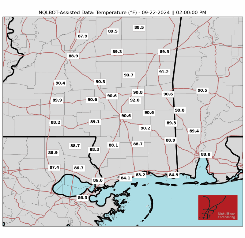
Speaking of this weekend, as the ridge of high pressure to the west shifts and slides by to the east, it will give us quite the boost in temperatures. Above are the actual air temperatures – not the Heat Index, Feels Like, or Experienced Temperatures – for the area. Hot stuff. We will also see a return flow from the Gulf. That means the humidity will be on the way up, as will the Heat Index Feels Like, and the Experienced Temperatures.
It looks like both days this weekend will top out between 95F and 100F, but Sunday – given the extra humidity – may feel quite a bit warmer.
Next week, scattered showers and storms will be the name of the game. Morning data isn’t as aggressive with the rainfall totals, nor the local impacts, as previous model runs. That would be good news for flooding, but bad news for the heat. We will continue to monitor trends.
There’s also a disturbance in the southern Gulf we’re watching that could develop over the next week. Right now, computer weather models show it sliding into Mexico. But there is a secondary wave that may add some “chaos” to the relatively straight-forward situation by late next week.
REGIONAL DAY TO DAY FORECAST
Today: Sunny. Highs in the mid 90s. Northeast winds around 5 mph.
Tonight: Mostly clear. Lows around 70. Southwest winds around 5 mph in the evening, becoming light and variable.
Friday: Sunny. Highs in the upper 90s. North winds around 5 mph, becoming east around 5 mph in the afternoon.
Friday Night: Mostly clear. Lows in the lower 70s. South winds around 5 mph in the evening, becoming light and variable.
Saturday: Sunny. Highs in the upper 90s. North winds around 5 mph, becoming southeast around 5 mph in the afternoon.
Saturday Night: Mostly clear. Lows in the lower 70s.
Sunday: Mostly sunny. A slight chance of showers and thunderstorms in the morning, then a chance of showers and thunderstorms in the afternoon. Highs in the mid 90s. Chance of rain 30 percent.
Sunday Night: Mostly cloudy in the evening, then becoming partly cloudy. A slight chance of showers and thunderstorms. Lows in the lower 70s. Chance of rain 20 percent.
Monday: Partly sunny. A chance of showers and thunderstorms in the morning, then showers and thunderstorms likely in the afternoon. Highs in the lower 90s. Chance of rain 60 percent.
Monday Night: Mostly cloudy with a chance of showers and thunderstorms. Lows in the mid 70s. Chance of rain 30 percent.
Tuesday: Mostly cloudy in the morning, then becoming partly sunny. A chance of showers and thunderstorms. Highs in the upper 80s. Chance of rain 30 percent.
Tuesday Night: Mostly cloudy. A chance of showers and thunderstorms, mainly in the evening. Lows in the lower 70s. Chance of rain 30 percent.
Juneteenth: Partly sunny with a chance of showers and thunderstorms. Highs in the lower 90s. Chance of rain 30 percent.


