Not much has changed with the severe weather threat for late Wednesday and into Thursday morning for the Gulf Coast. But the few pieces of the puzzle that have changed, do increase the potential for seeing severe weather a bit.
Not much. But it is something that is noteworthy.
The changes
Now that we are a bit closer in time to the potential for severe weather, we have access to a few extra computer weather models. These models are known as “Convective Allowing Models” or CAMs for short. There models are high-resolution enough to try to pick out where individual storms may develop.
A lot like the “Storm Trax” I use on TV, the idea is we want to let these models find where the strongest storms may be. They aren’t always perfect, but they are helpful. These models are the HRRR, the HRW suite of models, and the NAM-3km.
The change within the data is that these CAMs show the storms arriving a bit sooner than the earlier model guidance was suggesting. Instead of storms moving through Louisiana overnight and Mississippi in the morning. The CAMs show the storms developing in the early evening in Louisiana and pushing through Mississippi overnight and into Alabama by morning.
The shift in timing of the storms means that those storms will be moving through an atmosphere that is different.
Take a look at atmospheric data for western Mississippi at 9pm Wednesday night northwest of McComb:


The difference between the two Skew-Ts above isn’t, necessarily glaring at all. It is pretty slight. But the difference between the two is the difference between an actual tornado threat and one that just shows up in the “PSBL HAZ TYPE” box.
The data from Tuesday night on the NAM (left) shows a bit of a cap of warm air (around 700mb) and a smaller hodograph. So despite more CAPE (instability) within the atmosphere, it isn’t as accessible to any one particular storm. On top of that, because the hodograph isn’t as large, any storm would not have access to as much turning of wind with height.
Meanwhile, the HRRR data (right) shows no cap of warm air, lower CAPE values (instability) but a larger hodograph. This means that while the stretching within the storms updraft wouldn’t be as robust for any one particular storm, there is no cap to overcome and the turning of wind with height is more in-line with a historical tornado threat for the region.
And looking at the Updraft Helicity streaks, it shows there are three areas to watch.
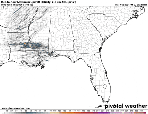
Those areas will be highlighted below.
The forecast
I want to stress, again, that this is some really subtle stuff. It leaves the region in. situation where things are pretty conditional, meaning the potential for something to happen is low but if that potential manifests the outcome could lead to a pretty significant thunderstorm capable of producing heavy rain, wind gusts greater than 60mph and a tornado.
I’m not going to post the SPC outlook here because the new outlook isn’t due out for another hour and change (as of me writing this). And I don’t want to post something old since many of you will be reading this on Wednesday morning after the SPC forecast is out.
For info on the SPC outlook, head here
Looking at the region south of I-20, the main timeline for concern across the region will be between 6pm Wednesday night and 6am Thursday morning. Underneath that region-wide concern for the potential for a few severe storms, it looks like there will be three areas to watch for different threats.
From west to ast, Area 1 in Louisiana and west-central Mississippi, Area 2 across south Mississippi, and Area 3 southern Alabama and the western Florida panhandle.

Each area outlined in orange will have different threats and a timeline that is different. Teh smaller ellipse in red indicates an area highlighted by the CAMs to have a higher risk for a stronger storm to pass through.
Area 1
Threats: Heavy rain, frequent lightning, wind gusts up to 60mph, hail up to the size of quarters, a tornado or two.
Timeline: 4pm – 10pm
Area 2
Threats: Heavy rain, frequent lightning, wind gusts up to 65mph, hail up to the size of pennies, a brief tornado
Timeline: 10pm – 4am
Area 3
Threats: Heavy rain, localized flash flooding, frequent lightning, wind gusts up to 50mph
Timeline: 4am – 10am
The Bottom Line
Showers and storms will move through the region Wednesday night and into Thursday morning. Some of these storms will be strong while others may be severe. Heavy rain, frequent lightning, wind gusts up to 65mph, hail up to the size of quarters, and tornadoes are possible.
The timeline is from 6pm in Louisiana all the way to 6am in Alabama and the Florida panhandle.
If you live in Louisiana, keep an eye to the sky in the evening. And have a NOAA Weather radio nearby or an app on your phone. Since these storms will be moving through in the evening, if you have any plans, make sure those plans include a way to get alerts from the NWS.
If you live in Mississippi, have your NOAA Weather radio nearby overnight while you sleep. Have an app on your phone that will ping you when a warning is issued. While the anticipation is not for tornadoes, a tornado cannot be ruled out. Plus, with wind gusts up to 65mph possible, that can easy knock down a tree. So you want to make sure you’re woken up by the alerts from the NWS so you can take cover.
If you live in Alabama or Florida, as you head out the door in the morning check the forecast and condition outside. Depending on how storms line up, there may be a chance that your normal commute to work may take a bit longer and you may encounter a lot of water on the roads


Thanks Nick. It looks like Marion county is in a bulls eye for bad weather. Can’t wait for an update.
Nick, you really pissed someone off. They’ve cut you out of the weather program. How are we supposed to stay safe if they don’t give us the kind of forecast you gave us? I don’t like this new version of the weather. I’ll have to find a new weather station. Geez I’m so upset we are losing you.
“KARMA” NICK FOR ALL THE BAD THINGS YOU’VE DONE TO OTHER PEOPLE IS NOW COMING BACK TO YOU. I ALWAYS KNEW KARMA WOULD FIND YOU SOMEDAY!!! LOL … NOW WHAT ARE YOU GOING TO DO? LOL