The heat felt today will stay well into tomorrow with highs in the 90s, but there is a chance for a quick cooldown thanks to some scattered showers entering into the central part of our area Wednesday afternoon.
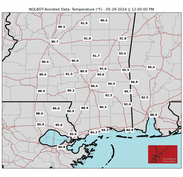

The heat experienced today was no joke, and with highs in the 90s mixed with factors like humidity and the sun, it felt even hotter. The chance for scattered showers in southern Louisiana will persist through the evening, with lows in the 60s.
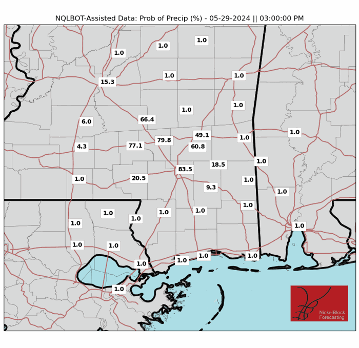
The same trend is expected for Wednesday, with experienced temperatures expected to range from high 90s and well into the 100s in some areas. The main difference is the chance for scattered storms Wednesday afternoon, which may help cool us down a little moving into the rest of the week. These storms are not expected to be severe and will move out of the area quickly. More scattered showers are expected for Thursday, with highs in the upper 80s
Looking towards the end of the week, isolated showers are expected for the western part of our area, with a chance for stronger storms over the weekend. These storms will allow for a little break from the heat with highs in the 80s, before warming back up at the start of next week.
REGIONAL DAY TO DAY FORECAST
Tonight: Mostly clear. Lows in the upper 60s. South winds around 5 mph in the evening.
Wednesday: Mostly sunny. A slight chance of showers and thunderstorms in the afternoon. Highs in the lower 90s. East winds around 5 mph, becoming south around 5 mph in the afternoon. 20 percent chance of rain.
Wednesday Night: Mostly cloudy. Lows in the upper 60s. Northeast winds around 5 mph in the evening.
Thursday: Partly sunny. A slight chance of showers and thunderstorms in the afternoon. Highs in the upper 80s. East winds around 5 mph, becoming south around 5 mph in the afternoon. 20 percent chance of rain.
Thursday Night: Mostly cloudy. Lows in the upper 60s.
Friday: Mostly sunny. A slight chance of showers and thunderstorms in the afternoon. Highs in the upper 80s. 20 percent chance of rain.
Friday Night: Partly cloudy. A slight chance of showers and thunderstorms. Lows in the upper 60s. 20 percent chance of rain.
Saturday: Partly sunny with a chance of showers and thunderstorms. Highs in the upper 80s. 50 percent chance or rain.
Saturday Night: Mostly cloudy in the evening, then becoming partly cloudy. A chance of showers and thunderstorms. Lows in the upper 60s. 50 percent chance of rain.
Sunday: Partly sunny with a chance of showers and thunderstorms. Highs in the mid 80s. 50 percent chance of rain.
Sunday Night: Partly cloudy with a slight chance of showers and thunderstorms. Lows in the upper 60s. 20 percent chance of rain.
Monday: Mostly sunny. A slight chance of showers and thunderstorms in the morning, then a chance of showers and thunderstorms in the afternoon. Highs in the upper 80s. 30 percent chance of rain.


