A wee bit ridgy out there! We have a bit of an Omega Ridge in the central US. This helps to keep our area pretty warm.
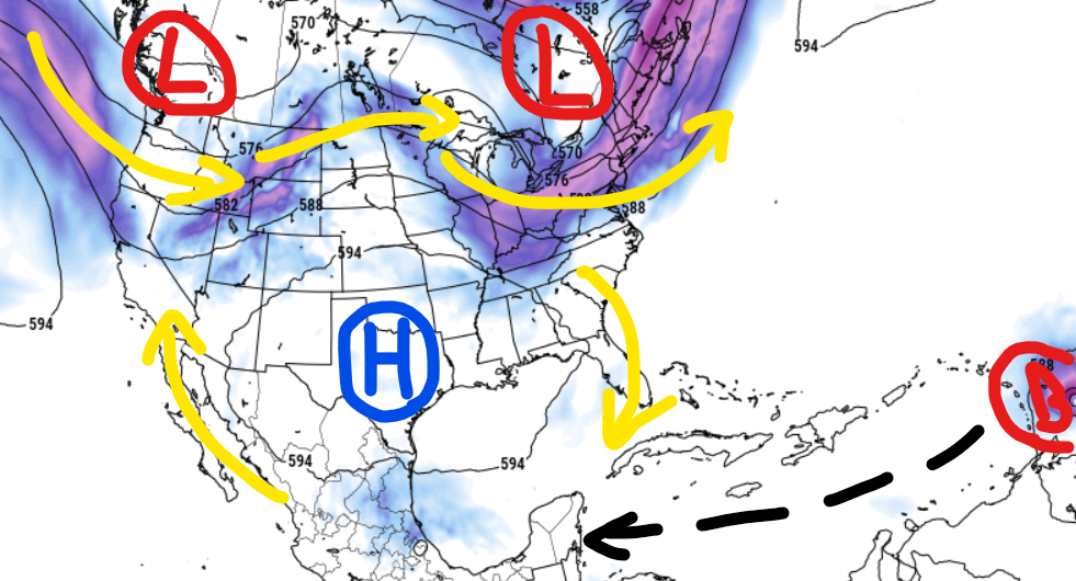
The toher things it is doing is help to keep everything in the tropics – include Beryl – away from our area.
But we are hot.
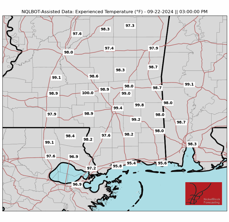
Today will be another hot one with Heat Advisories in effect across parts of the region. Heat Index values around 110F with Experienced Temperatures between 105F and 110F. We may catch another few storms this afternoon, but I wouldn’t bet the farm.

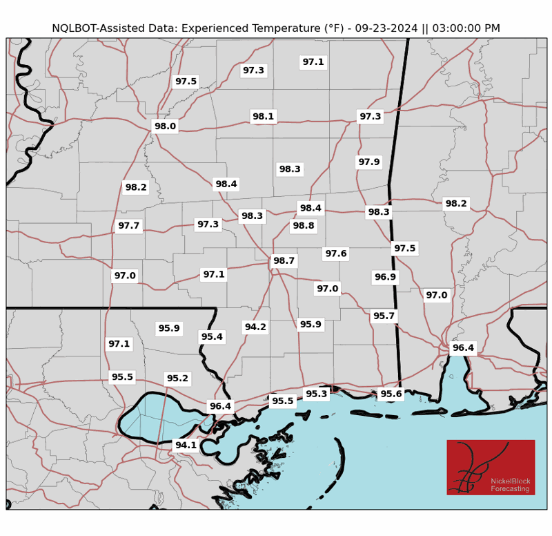
This pattern should hold through the next five days – with storms possible each day and temperatures around 95F with Heat Index & Experienced Temperatures around 105F to 110F. Looking at the temperatures on the 4th of July (and 5th of July), we are still looking at hot temperatures and a shot for some afternoon storms.
A frontal boundary expected to move into the region over the weekend could bring some relief from the heat. But, again, I wouldn’t bet the farm.
That same trough / cold front will split the ridge into two parts – one west and one east. That may open the door for Beryl to eek farther north than currently forecast. That is still TBD.
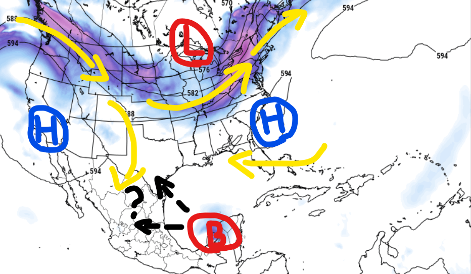
Still, it doesn’t look like a problem for southeast Louisiana, southern Mississippi or Lower Alabama.
REGIONAL DAY TO DAY FORECAST
Today: Sunny. A slight chance of showers and thunderstorms this afternoon. Highs in the upper 90s. North winds 5 to 10 mph. Chance of rain 20 percent. Heat index values up to 112.
Tonight: Mostly clear. A slight chance of showers and thunderstorms in the evening. Humid with lows in the mid 70s. North winds around 5 mph in the evening, becoming light and variable. Chance of rain 20 percent. Heat index values up to 105 early in the evening.
Tuesday: Mostly sunny. A slight chance of showers in the morning, then a chance of showers and thunderstorms in the afternoon. Humid with highs in the mid 90s. Northeast winds around 5 mph, becoming southeast in the afternoon. Chance of rain 40 percent. Heat index values up to 111.
Tuesday Night: Partly cloudy with a slight chance of showers and thunderstorms. Humid with lows in the mid 70s. Southeast winds around 5 mph. Chance of rain 20 percent. Heat index values up to 106 early in the evening.
Wednesday: Mostly sunny. A chance of showers and thunderstorms in the morning, then showers and thunderstorms likely in the afternoon. Humid with highs in the lower 90s. Southeast winds 5 to 10 mph. Chance of rain 40 percent. Heat index values up to 107.
Wednesday Night: Partly cloudy in the evening, then becoming mostly clear. Lows in the mid 70s. Heat index values up to 105 early in the evening.
Independence Day: Mostly sunny. A slight chance of showers and thunderstorms in the morning, then a chance of showers and thunderstorms in the afternoon. Highs in the mid 90s. Chance of rain 30 percent. Heat index values up to 110.
Thursday Night: Partly cloudy in the evening, then becoming mostly clear. Lows in the mid 70s. Heat index values up to 105 early in the evening.
Friday: Sunny. A chance of showers and thunderstorms in the afternoon. Highs in the upper 90s. Chance of rain 30 percent. Heat index values up to 110.
Friday Night: Partly cloudy in the evening, then becoming mostly clear. Lows in the mid 70s. Heat index values up to 105 early in the evening.
Saturday: Mostly sunny. A slight chance of showers and thunderstorms in the morning, then a chance of showers and thunderstorms in the afternoon. Highs in the mid 90s. Chance of rain 40 percent. Heat index values up to 110.
Saturday Night: Partly cloudy. A slight chance of showers and thunderstorms in the evening. Lows in the mid 70s. Chance of rain 20 percent. Heat index values up to 105 early in the evening.
Sunday: Mostly sunny. A slight chance of showers and thunderstorms in the morning, then a chance of showers and thunderstorms in the afternoon. Highs in the mid 90s. Chance of rain 40 percent. Heat index values up to 110.


