It looks like we will be affected by a hurricane here during the next few days. But we aren’t worried about heavy rains, damaging wind and storm surge. We will just see some high clouds.

Those clouds will start to drift over the area as we head through the day tomorrow and Wednesday. The storm will impact the west coast of Mexico with 100mph wind, up to 15 inches of rain and a dangerous storm surge up to 6ft (maybe higher).
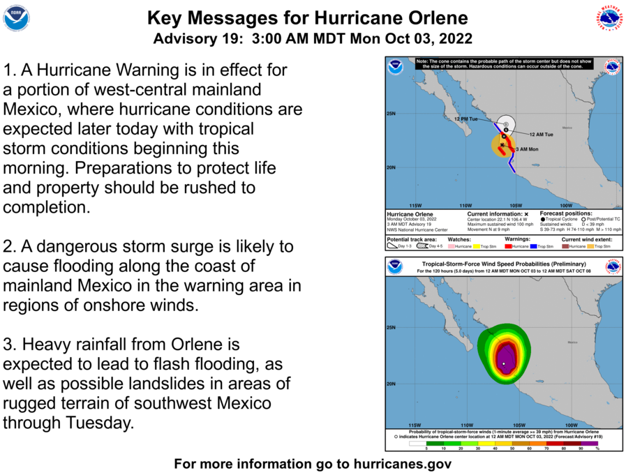
Once it moves inland though, it will be shredded by the mountains and all that will be left as if continues to move northeast will be some high cloud cover.
On our side of the tropics, there is also some activity. There are two waves worth monitoring, but only one has a chance to get ‘close to home’ during he next two weeks. The area shaded in orange on the map below is where Invest 91L is located. This wave will be moving through he same – general – area that Ian just passed through.

The main difference between this wave and Ian is that the puzzle pieces of the atmosphere have shifted and the likelihood that this wave follows the same exact path and strengthens in a similar way are much lower.
We may still see something develop, sure. But just because it is in the same area doesn’t mean a similar outcome. Thankfully.
Right now, model guidance is pretty unenthusiastic about robust development. And nothing is pointing this thing toward the mainland of the United States. And, as always, when model guidance is trying to give a forecast track for these things before they form, we need to take any one individual line on the spaghettis plots with a grain of salt.


For the moment it is a potential system worth monitoring in the coming days, but nothing more. It wouldn’t be close enough to the US to bother anyone until late next week.
DAY TO DAY FORECAST
Today
Sunny. Highs in the lower 80s. North winds 5 to 10 mph.
Monday Night
Mostly clear. Lows in the upper 50s.
Tuesday
High clouds and diffuse sunshine. Highs in the mid 80s.
Tuesday Night
Partly cloudy. Lows in the upper 50s.
Wednesday
More high clouds. Highs in the mid 80s.
Wednesday Night
Mostly clear. Lows in the upper 50s.
Thursday
Sunny. Highs in the upper 80s.
Thursday Night
Mostly clear. Lows in the upper 50s.
Friday
Mostly sunny. Highs in the upper 80s.
Friday Night
Partly cloudy. Lows in the upper 50s.
Saturday
Mostly sunny. Highs around 80.
Saturday Night
Partly cloudy in the evening, then becoming mostly clear. Lows in the lower 50s.
Sunday
Sunny. Highs around 80.


