The weather continues to be dry around here after – what probably feels like – another soggy Summer. Temperatures will climb back to around 90 today, as the humidity starts to return, too. No real chance for rain today, but I suppose a shower or storms can’t be completely ruled out.
Though, I wouldn’t bother with the umbrella when you head to a football game tonight.
Thankfully, the current pattern isn’t exactly one that produces a lot of thunderstorm activity for the area. With a ridge of high pressure building in to our west and a teeny-tiny area of low pressure brewing to our east, we are caught in a northerly flow, pulled well-away from the track of any major storm systems.
It should also keep the humidity at a reasonable level.

And that pattern looks to hold into next week. Which means we should stay dry. The plants will love this. Your allergies may not.
By next Wednesday, that ridge really gets anchored across Oklahoma and Arkansas. That should put a bit of a block up on most (keyword: most) tropical riff-raff that may try to enter the Gulf from swinging this direction. But if that ridge anchors farther east or isn’t as stout, that changes a lot of things.

For the moment, though, this is the data we are seeing and it should keep the area dry through the middle of next week. As that ridge shifts eastward, we will have to wait and see how it interacts with Fiona. There is a chance it stalls the tropical system or maybe even turns it back to the west.
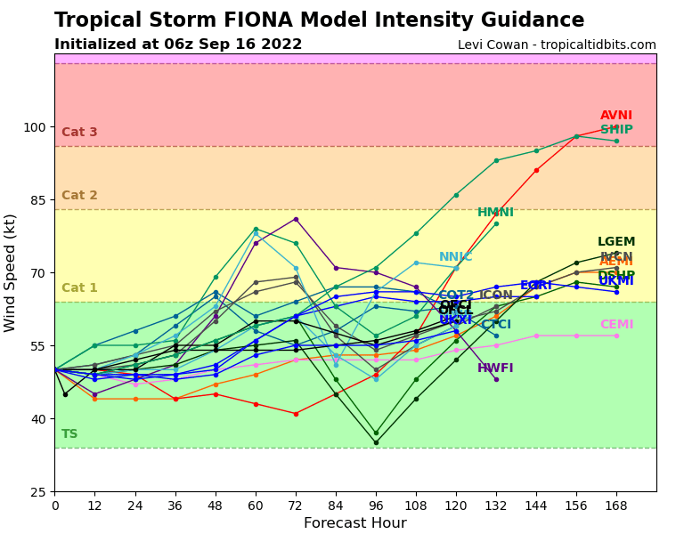
Speaking of Fiona, here is the latest as of this writing (the 4a update):

The model guidance continues to show a good bet that this thing turns north at some point, it just continues to shift that point to the west.


Most of that is related to how slowly model guidance is now showing Fiona will organize and strengthen. This was anticipated by the humans, but not picked up by the computers – and the computers continue to struggle with it.
This is something that Gulf Coast / East Coast folks should monitor, but not “worry” about for the next five (ish) days, at least, and then we can start chipping away at who needs to continue to watch Fiona and who can “stand down” so to speak.
DAY TO DAY FORECAST
Today
Sunny. Highs around 90.
Tonight
Mostly clear. Lows in the mid 60s.
Saturday
Sunny with a stray storm possible. Highs around 90. Chance of rain 10 percent.
Saturday Night
Mostly clear. Lows in the upper 60s.
Sunday
Passing clouds with a few storms possible. Highs in the upper 80s. Chance of rain 10 percent.
Sunday Night
Mostly clear. Lows in the upper 60s.
Monday
Sunny. Highs in the lower 90s
.Monday Night
Clear. Lows in the upper 60s.
Tuesday
Sunny. Highs in the lower 90s.
Tuesday Night
Clear. Lows in the upper 60s.
Wednesday
Sunny. Highs in the mid 90s.
Wednesday Night
Clear. Lows around 70.
Thursday
Sunny. Highs in the mid 90s.

