Looking at the maps this morning, expect scattered storms in the afternoon and early evening. This may impact some of the same spots that picked up a fair bit of rain last night, too. Aside from that, it will be hot and humid, with heat indices in the triple digits. Again.

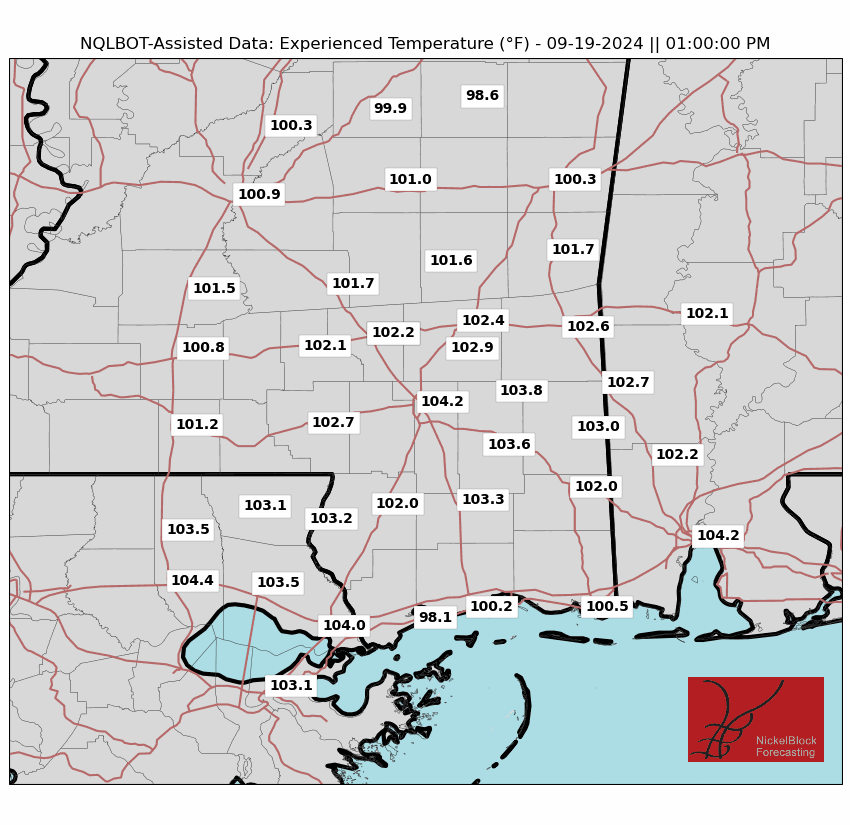
The Experienced Temperatures may not look quite as hot given the extra clouds here and there as well as a bit of a breeze. All that said, a Heat Advisory is in place for parts of the area.
Teh heat will be with us through most of the week with temperatures in the upper 90s and heat indices between 105-115 degrees. There will be isolated to scattered rain to help give us some relief in the afternoon.
By late this week and through the weekend, more showers and storms will bring cooler, more seasonable temperatures, with a chance of flash flooding along the coast.
Looking out a bit further in time, both the operational GFS and ECMWF are pointing toward an area of loosely organized disturbed weather near the Keys by later next week. The steering current at that time would be to plop it into the Gulf. So, this is worth monitoring for the next few days to get a better handle on what may shake out.
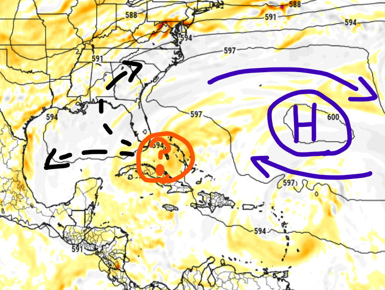
My current level of concern is near zero. But it is always good to keep tabs on things when they pop up on both models.
REGIONAL DAY TO DAY FORECAST
Today: Mostly sunny. A slight chance of showers and thunderstorms this morning, then showers and thunderstorms likely this afternoon. Highs in the lower 90s. Northwest winds around 5 mph, becoming southwest this afternoon. Chance of rain 60 percent. Heat index values up to 111.
Tonight: Partly cloudy with a slight chance of showers and thunderstorms in the evening, then mostly clear after midnight. Humid with lows in the mid 70s. Southwest winds around 5 mph. Chance of rain 20 percent.
Tuesday: Mostly sunny. A slight chance of showers and thunderstorms in the morning, then showers and thunderstorms likely in the afternoon. Humid with highs in the lower 90s. Southwest winds around 5 mph. Chance of rain 40 percent. Heat index values up to 110.
Tuesday Night: Mostly clear. Humid with lows in the mid 70s. South winds around 5 mph in the evening, becoming light and variable.
Wednesday: Sunny. A slight chance of showers and thunderstorms in the morning, then showers and thunderstorms likely in the afternoon. Humid with highs in the mid 90s. Southwest winds around 5 mph. Chance of rain 40 percent. Heat index values up to 110.
Wednesday Night: Partly cloudy with a chance of showers and thunderstorms in the evening, then mostly clear with a slight chance of showers and thunderstorms after midnight. Lows in the mid 70s. Chance of rain 30 percent.
Thursday: Mostly sunny. A chance of showers and thunderstorms in the morning, then showers and thunderstorms in the afternoon. Highs in the lower 90s. Chance of rain 70 percent. Heat index values up to 110.
Thursday Night: Showers and thunderstorms likely, mainly in the evening. Lows in the lower 70s. Chance of rain 50 percent.
Friday: Partly sunny. A chance of showers and thunderstorms in the morning, then showers and thunderstorms in the afternoon. Highs in the upper 80s. Chance of rain 60 percent.
Friday Night: Mostly cloudy with a chance of showers and thunderstorms. Lows in the lower 70s. Chance of rain 30 percent.
Saturday: Partly sunny with a chance of showers and thunderstorms in the morning, then mostly cloudy with showers and thunderstorms likely in the afternoon. Highs in the upper 80s. Chance of rain 30 percent.
Saturday Night: Mostly cloudy with a chance of showers and thunderstorms in the evening, then partly cloudy with a slight chance of showers and thunderstorms after midnight. Lows in the lower 70s. Chance of rain 20 percent.
Sunday: Partly sunny. A chance of showers and thunderstorms in the morning, then showers and thunderstorms likely in the afternoon. Highs in the upper 80s. Chance of rain 30 percent.


