First things first: It’ll be rather warm and windy today. Again. Yesterday most spots broke a record. Today we will likely do it again. And it won’t be hard! As of this writing (around 4am) the temperatures are in the mid 70s and the dewpoint values are in the low 70s with a 5-15mph wind.
That would count as “normal” for our high temperature – not what you would be waking up to.
Winds will remain breezy this afternoon thanks to a tight pressure gradient, with sustained winds of 20–25 mph and gusts up to 40 mph. Alongside the wind, heat and humidity will continue to surge, with high temperatures reaching the upper 80s to low 90s under partly cloudy skies—potentially tying or breaking daily records. Tonight will be another warm and muggy one, with lows only dipping into the low to mid 70s.
It’ll feel more like after the Fourth of July than before Easter.
As we head into the weekend, we will have another shot for storms across the region. And another shot for severe weather. It looks like the peak time for storms will be overnight Saturday and into Sunday morning.
But I think there is still some wiggle room on the timeline.
Right now, the Storm Prediction Center has highlighted our are with a Slight Risk for severe weather for Saturday and through Sunday, but it doesn’t mean both days are a washout or that storms will be all day, both days. Instead, it looks like a very specific six-hour window for storms across out area, but nailing down specifically when that will be has been a tougher egg to crack this time.
Recall that this Slight Risk is a “2” on the 1-to-5 scale where a “5” is the highest risk for the most significant severe weather.
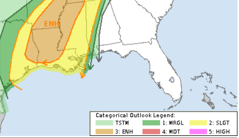
The Enhanced Risk, a “3” on the same scale, is just to our west.
The main concern with storms will be for brief heavy rain, lightning, wind gusts up to 65mph, hail up to the size of golf balls, and the potential for a few tornadoes (up to EF3 in strength).

I know reading that may cause the hair on your neck to stand up a bit given recent events locally and regionally – but this event, for us, I think will be less of a tornado event and more of a wind and hail event. As the storms kick out of Louisiana, I think they may start to lose a bit of steam as the “cold air” behind the storms will be modified and the mid- and upper-level winds may not be quite as favorable for storm organization in our area
But that is still a bit of TBD because the “favorableness” (is that even a word?) of the environment also has a temporal ingredient to it. So if storms arrive at a different time than currently projected relative to the environment we could be in a more favorable or less favorable situation for storms – and severe weather.
This morning, the HRRR & HRW model guidance is still juuuuuust a bit too far out. The higher resolution guidance like that only looks out about 48 hours. But as we move through the day today, we will start to get a better idea about how things may shake out with potency and timing-wise.
REGIONAL DAY TO DAY FORECAST
Friday: Mostly cloudy. A slight chance of showers and thunderstorms in the afternoon. Highs in the upper 80s. Southeast winds 10 to 15 mph with gusts up to 30 mph. Chance of rain 10 percent.
Friday Night: Cloudy. Lows around 70. Southeast winds 10 to 15 mph with gusts up to 25 mph.
Saturday: Mostly cloudy with a slight chance of showers and thunderstorms – mainly in the evening and overnight. Highs in the mid 80s. South winds 15 to 20 mph with gusts up to 35 mph. Chance of rain 40 percent.
Saturday Night: Mostly cloudy. Storms likely. Lows in the mid 60s. Chance of rain 70 percent.
Sunday: Storms early, then clearing. Cooler with highs in the mid 70s. Chance of rain 70 percent.
Sunday Night: Mostly cloudy. Can’t rule out a shower or rumble of thunder. Much cooler with lows in the lower 50s. Chance for rain around 20 percent.
Monday: Mostly cloudy in the morning, then becoming partly sunny. Highs in the mid 60s. Chance for rain around 20 percent.
Monday Night: Mostly clear. Lows in the mid 40s.
Tuesday: Sunny. Highs in the lower 70s.
Tuesday Night: Clear. Lows in the mid 40s.
Wednesday: Sunny. Highs in the mid 70s.
FORECAST MAPS
Select Data Set:


