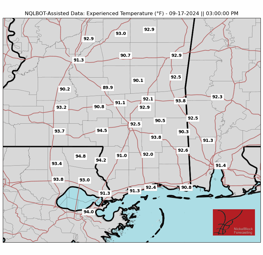
Today, we expect continued hot and dry conditions due to high pressure in the area. We are still on the east side of the ridge, so we will hold onto a “drier” northerly wind today. Temperatures this afternoon will climb to the mid-90s.
That changes as we move through the weekend.

This weekend is looking to be very hot. The high pressure system is sticking around and will be shifting o the east. That means we can expect the warmer temperatures to stick around, too. But add to that the increasing humidity on both Saturday and Sunday.
We get into a unique situation this weekend where the Experienced Temperatures end up being warmer on Saturday than Sunday while the Heat Index values will be warmer Sunday than Saturday. Specifically, this is based on how each is calculated. But generally, it is a good sign that both days will be quite hot.
But Sunday, as the ridge rolls east, we will start to get a return flow from the Gulf. This will introduce chances of rain and storms. However, it will still be very hot with temperatures in the upper 90s to around 100 degrees. The added moisture will bump Heat Index values up to around 110 for some folks.
For fun, I asked ChatGPT to show me a cartoon image of people staying cool in the heat:

As we move into early next week, the high pressure will continue to shift, bringing more moisture into the area. We will likely set up a bit of a unique scenario where we have a tropical disturbance in the southern Gulf, a ridge to our east and a potential conveyor belt of tropical moisture into the region. This may mean the potential for some flooding, but where and how much is still TBD.
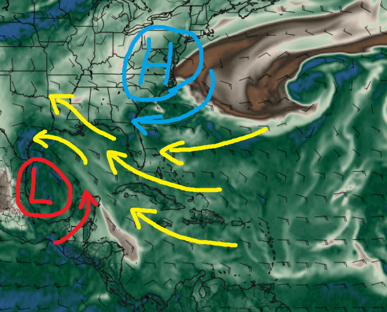
The latest from the ECMWF computer weather mode shows the bulk of the moisture pointed toward Texas, but in recent runs it has also shown it pointed toward Louisiana and Mississippi. Int he map above, the red “L” and blue “H” indicate the two areas of low and high pressure. The same-colored arrows indicate how those two areas direct the winds in the lower levels of the atmosphere. The yellow arrows are the direction the air – with all of the tropical moisture – will be traveling given that influence.
It will be a bit of a battle between where the area of low pressure to the south develops and travels as well as how strong the ridging is to the east.
REGIONAL DAY TO DAY FORECAST
Today: Sunny. Highs in the upper 90s. Northeast winds around 5 mph, becoming east around 5 mph this afternoon.
Tonight: Clear. Lows in the lower 70s. South winds around 5 mph in the evening, becoming light and variable.
Saturday: Sunny. Highs in the upper 90s. North winds around 5 mph, becoming southeast around 5 mph in the afternoon.
Saturday Night: Mostly clear. Lows in the lower 70s. South winds around 5 mph.
Sunday: Sunny. A slight chance of showers and thunderstorms in the morning, then a chance of showers and thunderstorms in the afternoon. Highs in the mid 90s. Southeast winds 5 to 10 mph. Chance of rain 40 percent.
Sunday Night: Partly cloudy in the evening, then becoming mostly cloudy. A chance of showers and thunderstorms. Lows in the mid 70s. Chance of rain 40 percent.
Monday: Partly sunny. A chance of showers and thunderstorms in the morning, then showers and thunderstorms likely in the afternoon. Highs around 90. Chance of rain 70 percent.
Monday Night: Mostly cloudy. A chance of showers and thunderstorms, mainly in the evening. Lows in the lower 70s. Chance of rain 30 percent.
Tuesday: Mostly cloudy with a chance of showers and thunderstorms. Highs around 90. Chance of rain 50 percent.
Tuesday Night: Mostly cloudy. A chance of showers and thunderstorms, mainly in the evening. Lows in the mid 70s. Chance of rain 50 percent.
Juneteenth: Partly sunny with a chance of showers and thunderstorms. Highs in the upper 80s. Chance of rain 40 percent.
Wednesday Night: Mostly cloudy in the evening, then becoming partly cloudy. A slight chance of showers and thunderstorms. Lows in the lower 70s. Chance of rain 20 percent.
Thursday: Mostly sunny. A slight chance of showers and thunderstorms in the morning, then a chance of showers and thunderstorms in the afternoon. Highs in the lower 90s. Chance of rain 40 percent.


